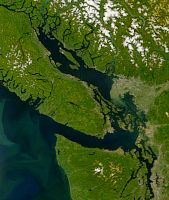
Have a look at this satellite image. It depicts an area that is now semi-officially known as the Salish Sea. (The name has been recognised by Canada and the State of Washington, but still needs to be adopted by the U.S. Board of Geographic Names.)
The east-west waterway on the south is the Strait of Juan de Fuca. The northerly-running one is the Strait of Georgia. Between them are the San Juan Archipelago.
To which strait does the archipelago belong? Just eyeballing it, it looks like they are in the Strait of Georgia. But the Strait of Georgia officially ends to the north of Orcas Island (the large northern claw-shaped island in the middle of the archipelago). So does that mean that the Jan Juan Islands (the American part of the archipelago) are in the Strait of Juan de Fuca?