Someone posted this link on facebook and while I found it interesting the comments on the actual website where less than enlightening … So I turn to the dope, what are these structures, paterns in China?
The third one (the 18-mile grid of lines) could be a solar farm or wind farm in the early stages of construction. China has plans for multi-gigawatt solar PV farms in Inner Mongolia.
OK, so what the hell is this one? Not featured in any blog yet as far as I can tell.
Chain-link fence design, with little square blocks of dots running diagonally through the center of the chain links. I have a theory but I’d love to know someone else’s thoughts.
(It’s somewhat different to the ones at the link above because runs right across a major highway.)
Unlike the folks at Nazca and the ones making the Crop Circles, Chinese artists can’t draw.
Either that, or it’s that freakin’ Modern Art that doesn’t look like nothin’
You watch and see – this is gonna attract those artsy-fartsy hippie beatnik aliens, instead of the ordinary ones.
The ‘bright cyan’ ones are probably that way as a result of colour tweaking applied to the images to render them more usable/realistic in some other aspect.
Looks like some kind of surveying/prospecting grid pattern - perhaps arranged this way so as to make it easy to create a bypass to an adjacent track if one part becomes blocked or impassable?
You can see ground-level photos of that area using the Street View man (drag onto the blue dots), but they don’t give much of a clue. There does seem to be a big radio mast with solar panels.
BTW I started a similar thread about the weird grid pattern in the OP a couple of years ago.
It’s that damn Christo.
He puts crapall over the place.
I don’t get it. It’s got to be some kind of joke I’m not getting. The first picture is obviously sunlight reflecting off ice or water in the erosion ditches.
Is it just a coincidence that the ditches are limited to a rectangular area?
Ditches of curiously uniform width, also.
The round one scares me the most. It seems to have variously sized structures sprinkled throughout. It would be an excellent test site for dispersal patterns of any released substance.
And 13-14 of the lines are ruler-straight too.
Maybe the Chinese have a sense of humor after all?
Maybe it would help if you saw three of the structures in context: they’re all in a line on the same valley wall. Also there’s another, blank square to the left of the grid square that hasn’t been featured in the articles so far. Presumably because it’s boring.
The crashed planes at th ecenter are even more disconcerting.
OK, here’s even more freaky: pop the coordinates 40.488966,93.50004 into Google Earth where the resolution is higher:
The square at the northern edge of the cyan ‘runway’ is covered in pock marks or craters.
Around both runways are what appear to be a few wadis. Running up and down the wadis are clusters of… things. They’re like horseshoe crabs buried under sand (unless my perspective is off and they’re actually craters). Many of them have tire tracks leading up to them. There are hundreds, possibly thousands of them. There’s also a cluster of them on the southern cross-piece of the cyan runway.
I thought they might just be a geological feature, but they only occur in the wadis around the ‘runways’.
ETA: the cyan shapes are made up of long panels. I suspect the color is due to them reflecting the sky.
I dunno. There are actual bright cyan ponds due to potash mining evaporation ponds around Moab, Utah as can be seen in this photo:
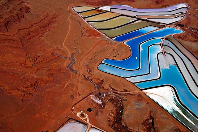
I’ve seen them and they really are that color.
Somebody annotated the region on Wikimapiaas a bomb range. Makes sense to me, especially given a few nearby features like this concentric cluster of planes and vehicles.
OK, never mind the weird Chinese structures. Why do several (not all) of those Gizmoido links take me to what appears to be the German version of Google maps?![]() :eek:
:eek: