Near the ring road around Cairo. I am puzzled.
Those were the ramps the slaves carried the large blocks up on to build the pyramids. You found them the mystery is solved.
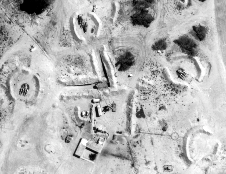
But really it does look like some type of facility where things are trucked to the top and then dumped inside the structure from above. Perhaps something like grain storage.
WAG: Some sort of military installation? Maybe an anti-aircraft site? The big ramp looks like a concrete bunker (note the tunnels underneath the peak) would be an appropriate place to put an anti-aircraft missile battery.
Supporting that, to the NE there’s an airstrip that looks like a military base. It’s got similar concrete ramp/bunker things, including a few with radar domes. It also has a few dozen hardened hangers.
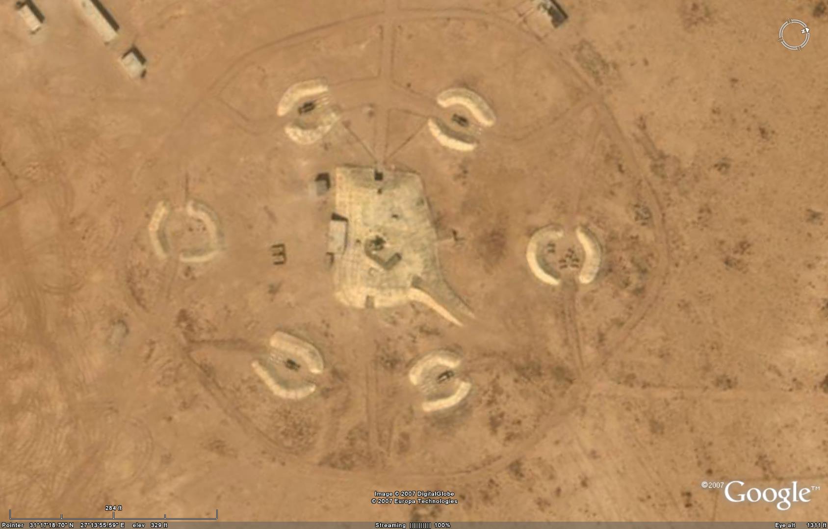
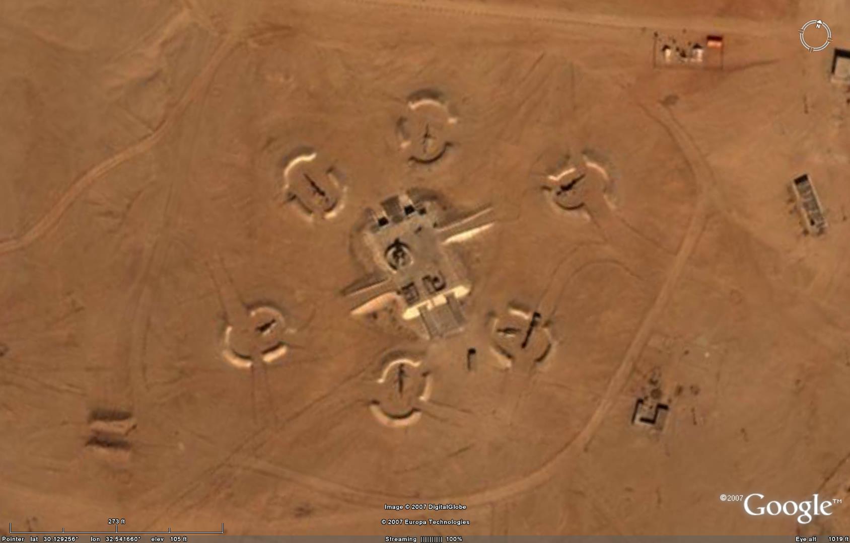
My guess is that it’s a missile site. Here are some similar looking Egyptian sites, also featuring ramps: 1, 2.
The sites linked to are for S-75/SA-2 surface-to-air missiles as part of an air defense system.
One thing I noticed if it is some kind of missile/military complex: there sure doesn’t seem to be much security.
I can’t spot a single gate or fence or anything. It seems like you can pull off the interstate and drive right up to it.
That’s a SAM site. The central structure is the control and RADAR facility while the six circular berms around the perimeter are the launcher sites. Looks like it’s been mothballed. Probably leftover from the wars with Israel. The ramps may be so that a truck can drive up on top to install/remove heavy gear. The additional site to the north is probably a supplementary RADAR.
Here’s a closeup of that airfield to the east. Another of the ramp structures but with what appears to be a doppler radar dome on top.
Military facility? Sounds like the perfect way to cover up pyramid building projects.
I agree it’s a SAM site. Extra missiles would probably be stored under the central raised bunker. When the battery deploys, the radar antenna goes up the ramp and sits on top of the bunker & the missile launchers go into the 6 circular revetments.
The other formation just north is a similar bunker & platform. No way to know if that’s for a longer-range search radar or a redundant targeting / fire control radar.
The airfield nearby to the east is a fighter base. We see hardened hangars & revetments for a dozen-plus aircraft at each end.
I’m not thinking the SAM installation is mothballed as much as it’s simply not on alert at this moment. It could probably be fully configured for battle within a few hours.
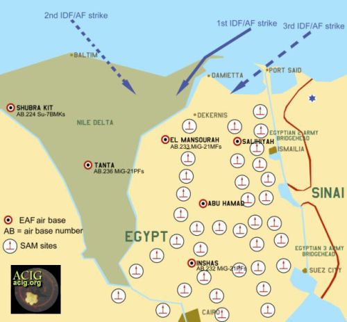
Here’s a rough diagram of Egyptian SAM sites during the Battle of el-Mansourah and the site in the OP would be one of the ones at the bottom of the diagram, east of Cairo.
That second image is an SA-3 installation.
Yeah, best overhead image of an installation I could find in a short search.
Here’s a web pageon Soviet SAM sites. On that page they show this image of an Egyption S-75/SA-2 site. Interesting similarity to the OP. Here’s another.
Brilliant cite. Thanks.
And a darn good pic it is. I wasn’t trying to take a dig at your cite. I was just adding the fresh info that it was an example of an SA-3. Sorry if my intent was unclear.
We won’t know what sorts of missiles are deployed to the OP’s location until they are deployed and somebody takes a pic.
In general, SAM sites used to have very iconic layouts driven by the rigid cabling between battery units & the limited range of traverse of the TELs. With more modern systems the sites are a lot less stereotypical and it’s difficult for anyone to know what’ll be deployed there just by looking at overhead imagery of the earthworks.
Interesting. None of those examples have the long ramp-looking bunkers that are in the OP’s example and the other nearby Egyptian sites (though there are a couple with smaller ramps). What would be the point of those huge concrete ramps?
I think people are misunderstanding. These are ramps DOWN, it seems to me. They lead to buried installations, therefore harder to take out.
I believe to enable a vehicle to drive up on top for quickly placing or removing radar gear without cranes or other special gear. Just tow or truck it right there in a few seconds.
And after reexamining the imagery, I conclude that they are definitely raised structures. This is due to a) the positions of shadows on the doors/entrances on the sides of the structures and their relation to the access roads, and b) a raised structure is more logical as it provides a much better vantage point for the radar.
They’re raised structures. The radar antenna(s) are mounted on trucks. The trucks drive up the ramp onto the raised platform, extend their outriggers, erect their antennas, and begin scanning for targets.
In otherwise flat terrain, that extra 30-50 feet of elevation can materially extend the reaction time to attack low flying aircraft.