In 1965, a bulldozer operator carved the initials of the company he worked for into the tundra. The letters were apparently 20 feet thick and 300 feet tall. I guess they were to direct bush pilots to the camp.
Reports of the size vary wildly, ranging from “360 square feet” to something like “3000” feet long. The letters were carved “near the western bank of the Canning River” said to be about 50 miles east of Prudhoe Bay Alaska.
Reports about the incident, as well as the aerial photo, are easy enough to find online. What I’m curious about, though, is where those letters are today. Because the activity disturbed the tundra vegetation and the permafrost, the bulldozed letters apparently turned into 10 foot deep ponds. Many of the sources indicate that they would be visible for “generations to come.”
I just spent about an hour on google earth looking for them, and haven’t been able to find them. Does anyone know where they are, or have a better idea of where they might be located along the Canning River?
It’s probably at Point Thompson, which is an area that Exxon acquired oil leases for. It’s possible that the graded area was built over by camp or drilling facilities.
That makes sense. I’m wondering if it’s the rectangular lake and disturbed area at 70 deg. 08’ 09’ N, 146 15’ 07’ W. (Just south of Thompson Point) It looks like the line from the arrow might still be visible.
I found a version of the photo that shows more too:
If I had to guess, based on the snow banks, I’d say the photo’s taken looking south. It’s hard to discern the topography though - tough to match it to google earth.
No, the Canning River is about 15 miles east of that spot (per google earth’s marker for the mouth). I dug up an aerial photo from the USGS from 1955 (that i don’t know how to link to) where that rectangle is clearly NOT visible and one from 1979 that isn’t clear. I can’t find free historical aerial photos online, the ones I found cost money to order full resolution.
What about this funny looking series of ponds: Google Maps
The photo data mentions its near the Smith Mountains. I can’t figure out where those are exactly (there appears to be some Phillip Smith Mountains somewhere in the Brooks Range). If they were doing exploration in those mountains (which they were for hardrock), the spot by that funny little body of water looks like about the nearest flat spot you could get an airplane into.
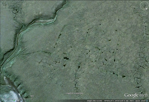
Ok, I see the river now. The only interesting feature I could find near the west bank were some perpendicular lines that appear to be man made roads or other scars on the tundra at 69°49’41.75 N, 146°28’31.05" W. Unfortunately, they lead into some low-res areas that don’t show much detail.
If you type “gsi” and “canning river” (or other variations) into google books, some information is visible, but none of the full text. A caption for a [not visible] picture says that the river in the foreground is the Canning River, the letters are also described as 80 feet tall, and the site is described as 50 miles from Prudhoe Bay and 15 miles inland from the Beaufort Sea. It looks like the incident was mentioned in some Congressional hearings, but I can’t get text for those, unless I get into some microfiche at school, which I’m not about to do.
If someone could find a hard copy of the book Fear Itself linked, there is a citation for that paragraph (the citations aren’t in the preview, though). Maybe it says something.
I wonder though if it was so controversial, maybe they sent another bulldozer out to fix it, at least to the point that it ceased to be an eyesore from the air. Or maybe make a rectangular lake out of it?