# 2021 US West drought and wildfire thread
**URL:** https://boards.straightdope.com/t/2021-us-west-drought-and-wildfire-thread/943991
**Category:** Miscellaneous and Personal Stuff I Must Share
**Created:** [June 10, 2021, 6:17pm UTC](https://boards.straightdope.com/t/2021-us-west-drought-and-wildfire-thread/943991 "2021-06-10T18:17:30Z")
**Posts on this page:** 20
**Page:** 8
### Author:  [@squeegee](https://boards.straightdope.com/u/squeegee)
#### Post date: [July 16, 2021, 3:56pm UTC](https://boards.straightdope.com/t/2021-us-west-drought-and-wildfire-thread/943991/141 "2021-07-16T15:56:37Z")
> [@wguy123](#):
>
> The US Wildfire map is very depressing:
> [https://www.arcgis.com/apps/webappviewer/index.html?id=2ff1677111ae4018ac705fcce7c3312f](https://www.arcgis.com/apps/webappviewer/index.html?id=2ff1677111ae4018ac705fcce7c3312f)
What a frustrating map. In California it shows dozens of fires that are “Acres burned” .1 or less, no containment information, fires that obviously don’t exist any more (I found ones from mid June, .1 acres, no containment info).
This map seems more useful. It’s on the same arcgis site, so I don’t know why this one is more accurate than the other (if it is). [linky](https://mediaprogram.maps.arcgis.com/apps/webappviewer/index.html?id=cc2890cca7c240e585d5bfb017ab8563)
---
### Author:  [@wguy123](https://boards.straightdope.com/u/wguy123)
#### Post date: [July 16, 2021, 5:09pm UTC](https://boards.straightdope.com/t/2021-us-west-drought-and-wildfire-thread/943991/142 "2021-07-16T17:09:37Z")
You are right! I took a closer look and found some old, small fires that I would think are out (one discovered 4/17 and only .2 acres). I wonder why it is including that data? It appears they are pulling the data from the same source since the large active fires seem to have the same details.
---
### Author:  [@squeegee](https://boards.straightdope.com/u/squeegee)
#### Post date: [July 16, 2021, 7:22pm UTC](https://boards.straightdope.com/t/2021-us-west-drought-and-wildfire-thread/943991/143 "2021-07-16T19:22:49Z")
[This map](https://firemap.sdsc.edu/) is also useful in it’s way. You have to click on the Layers icon at top right and choose everything under ‘fires’ except “historical fires”, then you get the active perimeter of the big fires that you can zoom into. “Historical fires” will give you what areas have been burned in recent years, to what time frame I have no idea.
---
### Author:  [@JaneDoe42](https://boards.straightdope.com/u/JaneDoe42)
#### Post date: [July 16, 2021, 7:59pm UTC](https://boards.straightdope.com/t/2021-us-west-drought-and-wildfire-thread/943991/144 "2021-07-16T19:59:09Z")
We’ve had several nice rains which helped the fire situation. Of course, the flash floods aren’t a lot of fun either, but at least they are fast.
**O’Connell Fire**
- **Start date:** July 12
- **Size:** 180 acres
- **Containment:** Unknown
- **Fuels involved:** Ponderosa pine, Juniper, Pinyon-Pine
- **Cause:** Lightning
- **Personnel:** 22
**Lime Fire**
- **Start date:** July 12
- **Size:** 2,063 acres
- **Containment:** 80%
- **Fuels involved:** Grass, brush
- **Cause:** Under investigation
**Elements Fire**
The fire was burning north of Kingman in the Cerbat Mountains, 6 miles northeast of Chloride.
- **Start date:** July 11
- **Size:** 1,343 acres
- **Containment:** 45%
- **Fuels involved:** Desert grass and brush
- **Cause:** Lightning
- **Total personnel:** 50
**Tiger Fire**
The fire was burning approximately 11 miles east of Crown King.
- **Start date:** June 30
- **Size:** 16,278 acres
- **Containment:** 59%
- **Fuels involved:** Tall grass, brush
- **Cause:** Lightning
- **Total personnel:** 13
**Middle Fire**
The fire is burning 3 miles west of the Verde River and 3 miles northeast of Red Creek Ranch. On July 11, the fire was active in the head of Squaw Creek and above the Verde River.
- **Start date:** June 29
- **Size:** 2,792 acres
- **Containment:** Unknown
- **Fuels involved:** Brush, grass
- **Cause:** Lightning
- **Total personnel:** 114
**Bottom Fire**
The fire was burning approximately 7 miles west of Bylas. A containment date of July 12 was given on July 10.
- **Start date:** June 28
- **Size:** 6,004 acres
- **Containment:** 95%
- **Fuels involved:** Timber, brush
- **Cause:** Lightning
- **Total personnel:** 56
**Snake Fire**
The fire was burning 7 miles west of Clints Well on the northern edge of West Clear Creek in Coconino National Forest.
- **Start date:** June 21
- **Size:** 130 acres
- **Containment:** 60%
- **Fuels involved:** Brush, grass, Ponderosa pine
- **Cause:** Unknown
- **Total personnel:** 5
**Alamo Fire**
The fire was burning 10 miles west of Nogales between Mexico, the Coronado National Forest and the Nogales Ranger District.
- **Start date:** June 20
- **Size:** 4,953 acres
- **Containment:** 90%
- **Fuels involved:** Short grass, brush
- **Cause:** Unknown
- **Total personnel:** 7
**Rafael Fire**
The fire was 4 miles north of Perkinsville, east of Highway 89. The fire was burning in Prescott National Forest, east of the Rock Butte Fires.
- **Start date:** June 18
- **Size:** 78,065 acres
- **Containment:** 95%
- **Fuels involved:** Grass, juniper, chaparral, ponderosa pine
- **Cause:** Lightning
- **Total personnel:** 12
**Rock Butte Fires**
A thunderstorm ignited five fires north of Paulden and west of Highway 89, including Red Hat Fire, Limestone Fire, Spring Fire, Rock Butte Fire and Silent Fire. Red Hat Fire, Limestone Fire and Silent Fire have been 100% contained.
- **Start date:** June 17
- **Size:** 802 acres
- **Containment:** 80%
- **Fuels involved:** Juniper, grass understory
- **Cause:** Lightning
- **Total personnel:** 12
**Backbone Fire**
The Backbone fire was burning 2 miles west of Pine, south of Highway 260.
- **Start date:** June 16
- **Size:** 40,855 acres
- **Containment:** 98%
- **Fuels involved:** Pinyon juniper, chaparral, brush, grass, cactus
- **Cause:** Lightning
- **Total personnel:** 5
**Bear Fire**
The Bear Fire was burning 25 miles north of Clifton in the Apache-Sitgreaves National Forests, near U.S. Highway 191.
- **Start date:** June 16
- **Size:** 23,868 acres
- **Containment:** 20%
- **Fuels involved:** Ponderosa pine, grass, brush
- **Cause:** Lightning
- **Total personnel:** 34
**Pinnacle Fire**
The Pinnacle Fire was burning in Coronado National Forest, approximately 13 miles south of Bylas.
- **Start date:** June 10
- **Size:** 34,417 acres
- **Containment:** 90%
- **Fuels involved:** Short grass, brush, timber
- **Cause:** Under investigation
- **Total personnel:** 49
**Previous fires with full containment**
- **Walnut Fire:** 10,667 acres. Contained as of June 29.
- **Telegraph Fire:** 180,757 acres. Contained as of July 4.
- **Slate Fire:** 11,435 acres. Contained as of July 5.
- **Painted Fire:** 936 acres. Contained as of July 5.
- **Snap Point Fire:** 9,843 acres. Contained as of July 13.
- **West Chev Fire:** 1,170 acres. Contained as of July 14.
- **Wyrick Fire:** 7,592 acres. Contained as of July 14.
- **Horton Fire:** 12,263 acres. Contained as of July 15.
- **Cedar Basin Fire:** 734 acres. Contained as of July 15.
- **Snake Fire:** 130 acres. Contained as of July 15.
---
### Author:  [@Snowboarder\_Bo](https://boards.straightdope.com/u/Snowboarder_Bo)
#### Post date: [July 16, 2021, 9:57pm UTC](https://boards.straightdope.com/t/2021-us-west-drought-and-wildfire-thread/943991/145 "2021-07-16T21:57:35Z")
Oregon’s Bootleg Fire is now too dangerous to fight; crews were pulled yesterday. Also, it is producing “fire clouds” and “fire tornados”.
> **[Oregon wildfire forms 'fire clouds' that pose danger below](https://apnews.com/article/science-fires-environment-and-nature-oregon-wildfires-3255d07c698462a9221c090f212ac98e)**
>
> PORTLAND, Ore. (AP) — Smoke and heat from a massive wildfire in southeastern Oregon are creating giant “fire clouds” over the blaze — dangerous columns of smoke and ash that can reach up to 6 miles (10 kilometers) in the sky and are visible from more...
---
### Author:  [@PastTense](https://boards.straightdope.com/u/PastTense)
#### Post date: [July 16, 2021, 11:33pm UTC](https://boards.straightdope.com/t/2021-us-west-drought-and-wildfire-thread/943991/146 "2021-07-16T23:33:22Z")
So what will stop it? Natural barriers? Which ones? Or rain? Forecast as to coming…?
---
### Author:  [@Snowboarder\_Bo](https://boards.straightdope.com/u/Snowboarder_Bo)
#### Post date: [July 16, 2021, 11:39pm UTC](https://boards.straightdope.com/t/2021-us-west-drought-and-wildfire-thread/943991/147 "2021-07-16T23:39:11Z")
Gotta remove the heat source underneath all that air is the only way to get rid of 'em.
[ETA:](https://en.wikipedia.org/wiki/Flammagenitus_cloud)
> [@](#):
>
> A flammagenitus cloud can help or hinder a fire. Sometimes, the moisture from the air condenses in the cloud and then falls as rain, often extinguishing the fire. There have been numerous examples where a large firestorm has been extinguished by the flammagenitus that it created.[[4]](https://en.wikipedia.org/wiki/Flammagenitus_cloud#cite_note-firecloud-4) However, if the fire is large enough, then the cloud may continue to grow and become a type of [cumulonimbus cloud](https://en.wikipedia.org/wiki/Cumulonimbus_cloud) known as a [cumulonimbus flammagenitus](https://en.wikipedia.org/wiki/Pyrocumulonimbus_cloud), which may produce lightning and start another fire.[[5]](https://en.wikipedia.org/wiki/Flammagenitus_cloud#cite_note-5) Even if there is no lightning, a cloud of this type can suddenly increase winds, which can dramatically worsen the wildfire that created the cloud.
---
### Author:  [@JaneDoe42](https://boards.straightdope.com/u/JaneDoe42)
#### Post date: [July 17, 2021, 3:07am UTC](https://boards.straightdope.com/t/2021-us-west-drought-and-wildfire-thread/943991/148 "2021-07-17T03:07:54Z")
Sad and terrifying. I haven’t spent a lot of time in Oregon, but always thought it was beautiful.
---
### Author:  [@Snowboarder\_Bo](https://boards.straightdope.com/u/Snowboarder_Bo)
#### Post date: [July 17, 2021, 3:16am UTC](https://boards.straightdope.com/t/2021-us-west-drought-and-wildfire-thread/943991/149 "2021-07-17T03:16:46Z")
It’s prolly still beautiful but in a fire-themed way now. You can sit and watch the light play as the flames on the ground and the heat distortion paint the flame cloud while fire tornados dance underneath.
---
### Author:  [@JaneDoe42](https://boards.straightdope.com/u/JaneDoe42)
#### Post date: [July 17, 2021, 4:55am UTC](https://boards.straightdope.com/t/2021-us-west-drought-and-wildfire-thread/943991/150 "2021-07-17T04:55:11Z")
Morbid\* but true. I’ve sat on our porch at night watching the glowing embers of the fire a couple of miles away. Its mesmerizing.
\*probably not the right word, but my mental thesaurus is tired.
---
### Author:  [@Snowboarder\_Bo](https://boards.straightdope.com/u/Snowboarder_Bo)
#### Post date: [July 17, 2021, 1:08pm UTC](https://boards.straightdope.com/t/2021-us-west-drought-and-wildfire-thread/943991/151 "2021-07-17T13:08:35Z")
This headline says a lot: [Unstable weather will continue to fuel huge Oregon blaze](https://apnews.com/article/science-environment-and-nature-oregon-weather-4730654e68e0f29d029cb9db8f709b87).
---
### Author:  [@TroutMan](https://boards.straightdope.com/u/TroutMan)
#### Post date: [July 17, 2021, 9:48pm UTC](https://boards.straightdope.com/t/2021-us-west-drought-and-wildfire-thread/943991/152 "2021-07-17T21:48:44Z")
Check out the NOAA satellite view as the Bootleg fire in Oregon blew up a few days ago.
>
---
### Author:  [@Snowboarder\_Bo](https://boards.straightdope.com/u/Snowboarder_Bo)
#### Post date: [July 17, 2021, 9:57pm UTC](https://boards.straightdope.com/t/2021-us-west-drought-and-wildfire-thread/943991/153 "2021-07-17T21:57:05Z")
There’s a new fire just south of Lake Tahoe:
> **[California fire prompts evacuations; Oregon blaze balloons](https://apnews.com/article/science-environment-and-nature-oregon-weather-4730654e68e0f29d029cb9db8f709b87)**
>
> SAN FRANCISCO (AP) — A rapidly growing wildfire south of Lake Tahoe jumped a highway, prompting more evacuation orders and the cancellation of an extreme bike ride through the Sierra Nevada on Saturday as critically dangerous wildfire weather loomed...
———
**TroutMan** , that satellite footage is incredible! Unreal how huge that fire is and how clearly you can see the fire in the fire cloud!
---
### Author:  [@Tamerlane](https://boards.straightdope.com/u/Tamerlane)
#### Post date: [July 17, 2021, 11:28pm UTC](https://boards.straightdope.com/t/2021-us-west-drought-and-wildfire-thread/943991/154 "2021-07-17T23:28:48Z")
Real threat of dry lightning over much of CA Sunday and Monday. It’s apparently a very hard phenomenon to accurately predict, so with luck it will be a dud event most everywhere. But definitely something to watch for in most of the state except the far northwest this weekend.
---
### Author:  [@Snowboarder\_Bo](https://boards.straightdope.com/u/Snowboarder_Bo)
#### Post date: [July 18, 2021, 1:56am UTC](https://boards.straightdope.com/t/2021-us-west-drought-and-wildfire-thread/943991/155 "2021-07-18T01:56:06Z")
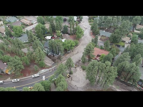
Flagstaff had flooding yesterday (90 second video):
[ ](https://www.youtube.com/watch?v=shE-e7PsaXA)
---
### Author:  [@Snowboarder\_Bo](https://boards.straightdope.com/u/Snowboarder_Bo)
#### Post date: [July 18, 2021, 9:22am UTC](https://boards.straightdope.com/t/2021-us-west-drought-and-wildfire-thread/943991/156 "2021-07-18T09:22:38Z")
> There were 70 active large fires and complexes of multiple fires that have burned nearly 1,659 square miles (4,297 square kilometers) in the U.S., the National Interagency Fire Center said. The U.S. Forest Service said at least 16 major fires were burning in the Pacific Northwest alone.
> **[California fire prompts evacuations; Oregon blaze balloons](https://apnews.com/article/science-environment-and-nature-oregon-weather-4730654e68e0f29d029cb9db8f709b87)**
>
> A rapidly growing wildfire south of California's Lake Tahoe jumped a highway, prompted more evacuation orders and canceled an extreme bike ride through the Sierra Nevada on Saturday as critically dangerous wildfire weather loomed.
---
### Author:  [@Snowboarder\_Bo](https://boards.straightdope.com/u/Snowboarder_Bo)
#### Post date: [July 19, 2021, 5:17am UTC](https://boards.straightdope.com/t/2021-us-west-drought-and-wildfire-thread/943991/157 "2021-07-19T05:17:46Z")
[Here’s some news:](https://apnews.com/article/lifestyle-science-health-fires-environment-and-nature-98130ca2eda415754bbb085b2dd0a23d)
> [@](#):
>
> The largest wildfire in the U.S. torched more dry forest landscape in Oregon on Sunday, one of dozens of major blazes burning across the West as critically dangerous fire weather loomed in the coming days.
>
> The destructive Bootleg Fire just north of the California border grew to more than 476 square miles (1,210 square kilometers), an area about the size of Los Angeles.
>
> Erratic winds fed the blaze, creating dangerous conditions for firefighters, said John Flannigan, an operations section chief on the 2,000-person force battling the flames.
---
### Author:  [@Snowboarder\_Bo](https://boards.straightdope.com/u/Snowboarder_Bo)
#### Post date: [July 19, 2021, 7:50pm UTC](https://boards.straightdope.com/t/2021-us-west-drought-and-wildfire-thread/943991/158 "2021-07-19T19:50:10Z")
[Well this is sure to surprise few and please fewer](https://apnews.com/article/science-fires-environment-and-nature-wildfires-3f102582aa78c2400a95374a2fb07529):
> [@](#):
>
> Northern California’s Dixie Fire roared to new life Sunday, prompting new evacuation orders in rural communities near the Feather River Canyon. The wildfire, near the 2018 site of the deadliest U.S. blaze in recent memory, was 15% contained and covered 39 square miles. The fire is northeast of the town of Paradise, California, and survivors of that horrific fire that killed 85 people watched warily as the new blaze burned.
>
> **Pacific Gas & Electric equipment may have been involved in the start of the Dixie Fire, the nation’s largest utility reported to California regulators.**
---
### Author:  [@Jasmine](https://boards.straightdope.com/u/Jasmine)
#### Post date: [July 19, 2021, 7:57pm UTC](https://boards.straightdope.com/t/2021-us-west-drought-and-wildfire-thread/943991/159 "2021-07-19T19:57:47Z")
Well, if we could find a way to transfer the fabulous amount of flood waters in western Europe to Lake Mead, we’d be all set. 😳
---
### Author:  [@Seanette](https://boards.straightdope.com/u/Seanette)
#### Post date: [July 19, 2021, 8:50pm UTC](https://boards.straightdope.com/t/2021-us-west-drought-and-wildfire-thread/943991/160 "2021-07-19T20:50:02Z")
I agree, @Jasmine. There are parts of the eastern US with flooding problems along with Europe. Meanwhile, here in the western US, we very much need their excess water. There has GOT to be some way to redistribute it.
[Previous page](https://boards.straightdope.com/t/2021-us-west-drought-and-wildfire-thread/943991.md?page=7)
[Next page](https://boards.straightdope.com/t/2021-us-west-drought-and-wildfire-thread/943991.md?page=9)