Hmm. I wonder: Is it possible to answer the GQ by analyzing actual, detailed GIS/digital topography data?
Some of that ought to be publicly available from the gov, right? Instead of saying “this state looks the flattest”, could we mathematically define “flatness” and then crunch the numbers on all surveyed elevation points?
If "flat"means either lowest difference between highest and lowest elevations (0’ and 345’ for FL), or lowest average elevation, or lowest “highest” elevation, I can’t see any other state than Florida being named flattest. An eyeball guesstimate of elevations shown in the second map on this page say better than 80% of the state is below 150’ in elevation.
No, they run parallel to the seaboard and don’t divide the north and south at all. I hike in the Appalachian mountains in NH nearly every weekend. I’ve never heard of the Appalachians as a divider of the north and south.
Numerous attempts having been made to answer your question, chowder, I am instead going to delve into your opening statement:
Why might this be? I can think of a few reasons.
Hilly, wooded terrain is more visually interesting to filmmakers, and makes for better shots and landscapes.
Hilly, wooded terrain is more familiar and easier to conceptualize for filmmakers, perhaps because the film industry is concentrated on the east and west coasts, where mountain sports and vacationing are very popular.
Filmmakers consciously or unconsciously disregard the flatter regions of the country known as “flyover country,” and are less likely to use these areas as locations or, indeed, set stories in such areas at all.
chowder personally exhibits confirmation bias, and is less likely to recall scenes shot in desert, prairie, scrubland, etc., than to remember those shot in mountainous, wooded, or valley locations.
chowder uses a more limited definition of the countryside than is commonly accepted.
There are a few forest coverage maps here, from Global Forest Watch, though the images seem to be in TIFF format which could be inconvenient to view on some platforms. Right now I’m looking at the one from the “Forest Cover of North America” section.
Judging only from this map and my own eyes, I’d say that Alaska has the most forest by absolute area — but that’s just because Alaska brings a honkin’ load of total area to the contest. Going instead by percentage of area and intensity of coverage, there are several states in the north-east that are almost entirely heavy woods (“heavy” meaning >60% tree cover), among them West Virginia, New Hampshire, and Vermont. For what it’s worth, that jibes with my own impressions when I’ve visited these states. They are mighty woodsy places.
Interesting contrast, by the way, between the Upper and Lower peninsulas of Michigan.
I realize all this doesn’t quite answer your question — which state is the most wooded, by some sort of objective metric — but I hope it’s useful.
The reference I used to dig up the mean elevation of Alaska says that Florida’s mean elevation is 100 feet:
We might also note that Britton Hill, Florida’s 345 ft high point, is in the panhandle. Most of the peninsula is as flat as stale beer.
Difference between highest and lowest elevations wouldn’t be good. Kansas has a high point of 4039 feet and a low of 679, making for a 3360 foot difference, about the same as Pennsylvania. With all due respect to people who have pointed out where there are some hills in the state, Kansas is in the Great Plains, and mostly quite flat. Pennsylvania is mostly hilly. We have to compensate for the general uphill tilt to KS from east to west. CA and AK would really stick out by this measure, of course.
If we had the data, I would suggest fitting each state to a plane, then using the average deviation from the fitted plane per unit area.
I’d still guess that Florida would win the prize. I would also guess that the lumpiest would turn out to be one of the states in the Appalachians or on the west coast. Mountain states like CO, WY and MT have large expanses of flat land in addition to “real” mountains. States like VT and WV are lumpy over most of their area, although the peaks aren’t as high. I’m not sure the existence of the Sierras and Death Valley (280 feet below sea level) in CA can compensate for the Central Valley.
“Stand in the place that you are… Now face North.. think about about direction and why you haven’t before.” -REM
Holy Schnikees! What don’t you people get about vague, general, and “J”? I am not making some all encompassing pronouncement, it’s just something that might help a foreigner visualize our mountainous regions in a general way.
I guarantee from an earlier, historical, explorer’s perspective when the New World was founded and included tracts from present day Canada down to Florida that the Mountainous regions (Appalachia) in the middle were as big a demarcation and barrier to the North and South as the Rockies were to Lewis and Clark as regards the East and West.
Also, as a Flatland Ohioan in Flatland Florida my perspective is that there are these Mountains in the middle (Appalachia) that I have to traverse to get from Flatlands to Flatlands.
No, no they did not. They were never a North/South barrier. At all. They were primarily an east/west barrier blocking off Ohio and the rest of the Old Northwest. You can go easily along rhe coast north south, and you can easily go past the Appalachians and go North/South that way.
I am sorry to say, but you are wrong. Period. Deal with it.
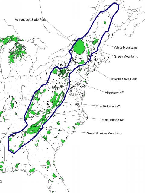
Except the Appalachians run due northeast at about a 45-degree angle (see the map I linked to earlier), which means they run north-south as much as they run east-west. Convention isn’t always correct; deal with it.
And there’s no need to take my word for it. I’ve taken the earlier map and drawn in lines to show North-South, East-West and the best-fit line showing the direction of the Appalachians.
Which would be correct if it was anything like a 45 degree angle, which it isn’t.
The only place where it approximates 45 degrees is at the very southern end. The only states that are cut off from doing directly south from flat to flat by the mountains are Michigan-Ohio-Indiana. And, with rare exception in our country’s history, there hasn’t been much economic or migratory movement from the Deep South to/from those states, partly because the Mississippi River made for an easy route, and partly because there really isn’t much reason for it.
Deal with it.
ETA: your line of fit doesn’t fit them at all, for most of their distance.
KLook at your own map. Note the state lines. They tend to be broken off at the east/west corridors along the Appalachians mountains. Moreover, I was speaking of historical pathways and movements. It’s easy to go north/south - if you can get across the Appalachians east/west.
The fact that they are technically a notrh/south barrier as well is utterly meaningless. I could just as meaninglessly claim they were an up/down barrier, which would arguably have more validty with respect to human travel.
Mmmmmmmmm I’ve measured the geology using Google Earth. They are about 900 miles from the western end to the eastern end (Alabama to Maine) measured directly West to East, and about 900 miles from the northern end to the southern end (same states), measured directly North to South. Geometry tells me that’s a 45 degree angle. So I was wrong, and I apologize. They are about 45 degrees. Q.E.D. was correct in that.
They still weren’t a barrier to North - South movement, however.
No, no they did not. They were never a North/South barrier. At all. They were primarily an east/west barrier blocking off Ohio and the rest of the Old Northwest. You can go easily along rhe coast north south, and you can easily go past the Appalachians and go North/South that way.
I am sorry to say, but you are wrong. Period. Deal with it.
[/QUOTE]
While, in general terms, I would say that you are more correct than Devilsknew, you take your assertion a bit too far. There is a reason why Fort Ticonderoga was built and used in two separate wars and why the French and British kept marching up and down the Hudson River/Lake Champlain/Richelieu River valley in their various attempts to attack each other or the rebel colonists during the War of Independence. From Boston to Quebec, there is no easy path across the Appalachian Mountains, effectively separating North (Canada) from South (13 Colonies/United States). Benedict Arnold’s attack on Quebec up the Kennebec valley and down the Chaudière valley was notable for its surprise value using an unexpected passage through the “mountains” of what became Maine.
There is no place in the U.S. where the Appalachians divide “North” from “South” and I do not recall ever reading where anyone identified the Appalachian range as a “North/South boundary,” but it is too strong a statement to claim that they were never a North South barrier.
My contention is that the Appalachians are a North/South Boundary Culturally and Linguistically. Are those not also geographical considerations? Even the OP has his Highlanders and Lowlanders
My contention is that the symbology of that ├▬ also represents the major NSEW cultural boundaries as well as the mountains that divide us.
Why an Appalachian Trail if it were so easy to go from The North to the South? Or vicey versey…