There’s a different situation where “nag” is appropriate, or maybe even not strong enough. If I leave Google’s planned route for whatever reason, (like on the rare occasions that I suspect I have a better route in mind than Google does) it tries to get me back to that route, when in actuality it ought to just recalculate a new route from the current location. For example:
The ETA is 2:15, and I should turn right at the next corner.
I ignore that turn, and Google says, “Ok, turn right at the next corner. ETA is 2:17.”
I ignore that turn too, and Google says, “Ok, turn right at the next corner. ETA is 2:18.”
I ignore that turn too, and Google says, “Ok, turn right at the NEXT corner. ETA is 2:19.”
I ignore that turn too, and Google says, “Ok, turn right at the NEXT corner. ETA is 2:20.”
I ignore that turn TOO, and Google says, “Ok, fine, have it your way. There’s a highway one mile ahead. ETA is 2:16.”
Why couldn’t it tell me about the highway several steps earlier?
I’ll suggest that behavior is about stability of the route.
I don’t use any of that nav software stuff except to get a general ETA and some clairvoyance about jams 10-30 minutes ahead.
But I recently rode in a car with somebody who could not find their own home’s garage from a block away without a nav app. We were driving about 20 miles on surface streets around 4:30pm on a weekday. Broadly speaking the street geometry here is pure grid on 1 mile spacing. We had to go 20 miles south and 4 miles west. From the start point we could have gone straight south on one artery then straight west on another. Or west first then south. IMO they were interchangeable indistinguishable functionally.
The app started us S on the first artery then occasianlly would decide to zig over one half or one full mile to the west then continue south. Most times the driver followed, but twice they did not due to too-short notice to turn as told.
The ETA kept shifting by a minute at most, and sometimes no discernable change. It was positively exhausting to listen to this computer redirecting this poor schlub over what I assume was a rounding error of 30 seconds or so in a 40 minute drive.
I think it is standard for all GPS to base times on speed limits unless construction or accidents affect travel time. I always gain time on my GPS going to work because traffic is so sparse on the interstate, and I’m traveling well over the speed limit.
“Sparse” is not zero. How is your speed compared to the others? If you are going the same speed as them, then your logic is sound. But if you tend to pass most of the others, then it could well be that the times are based not on the speed limits, but on the speeders who aren’t quite as fast as you are.
I’ve noticed this a lot too the last couple of years. If I’m navigating to a store at an intersection, it will often throw in three useless turns at the very end to approach from another direction. I could see this if there was only one entrance, but it hasn’t been the case.
One example, I could drive 100 yards and turn into the CVS that I am currently looking at. Or I could turn right, left, left, and right to get there.
I’ve also noticed, as others have mentioned, it’s gotten really aggressive about routing off the highway. Driving from Chicago to Champaign you can take I57 complete with streetlights, shoulders, and gas stations. Or you could take a corn maze of rural roads where each intersection is a blindspot. That was at least a fun ride other than the two houses with Confederate flags.
Almost this exact thing happened to me just yesterday, except that tit was NOT at an intersection. If it was at an intersection, your conjecture about one intersection would have made sense. (The place might have several entrances, but Google might only know about the main one.)
In my case, the place I was going was in the middle of a long block, and Google had me circle around so that I could make a right turn from the main road directly into their parking lot. My suspicion is that Google didn’t offer the simpler drive, because it mistakenly considered the road to be a divided highway, which would have made turning left into the lot a Bad Idea.
Here’s one of the ones I was thinking of from a month or two ago:
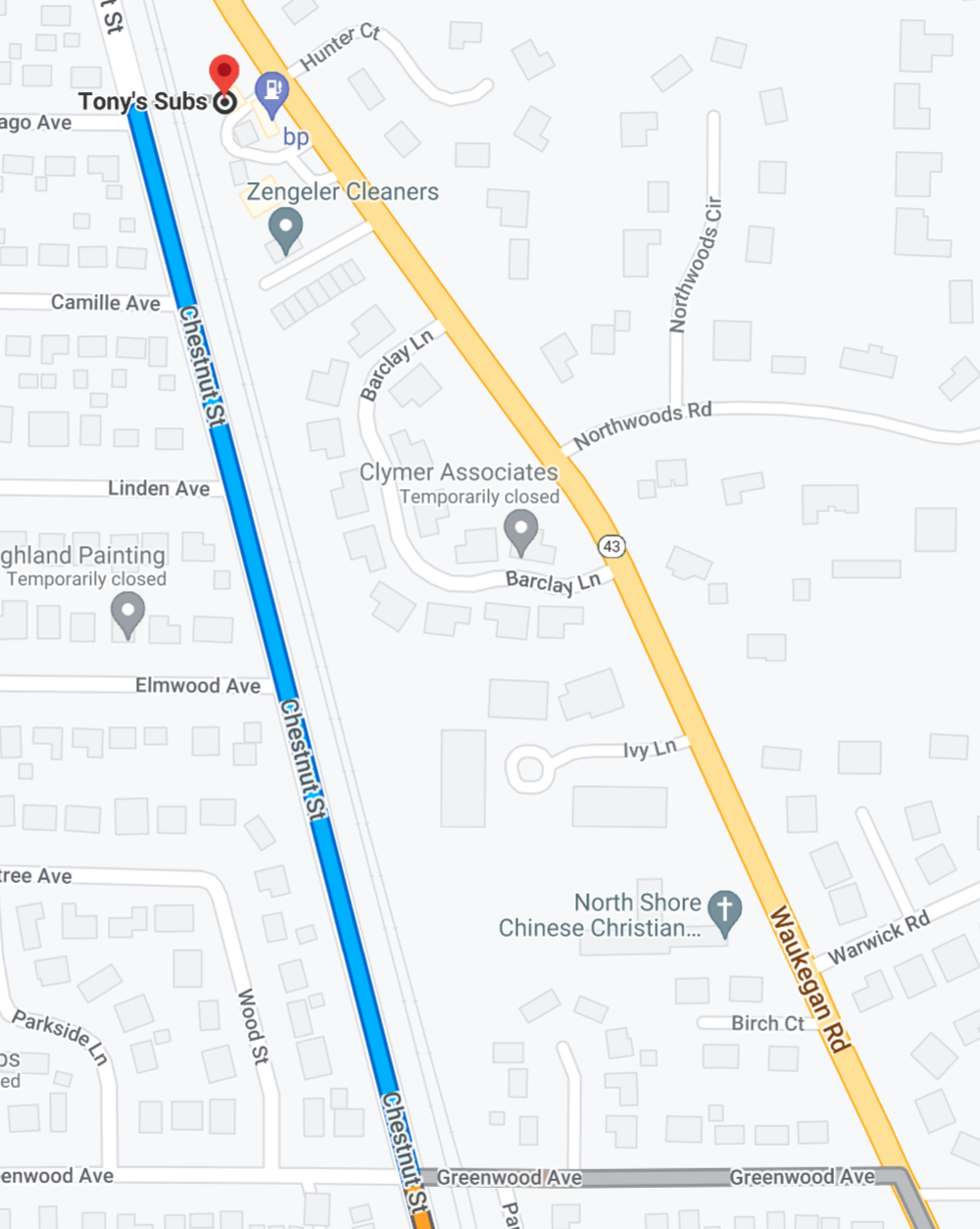
The address of the place I’m going to is on Waukegan Road. It is entered as such into Google Maps. Yet, for some reason, it takes me off Waukegan Road (see the gray alternate route, as well as the main route which avoids Waukegan Road) and takes me up Chestnut for no discernible reason. When I got to the destination, it said I had arrived. I was still on Chestnut! There’s a friggin blocked off area to the east with train tracks running that I can’t get over. I had to pull up Apple Maps, which routed me back down to Greenwood, and up Waukegan. Why in the heck did it take me off Waukegan in the first place?
This is SOOO similar to where I work! My company in an industrial park. Google should send people to our street address, which is right at the beginning of the driveway to the area. But - unfortunately - Google tries to send people to our exact building, which is at the very far end. So instead, Google sends people to the residential street which is closest to our actual building. And then I get phone calls, “Where are you? I can’t see your building?”
The weird thing for me is clearly all the data is there for Google Maps to route me properly. The address is not on Chestnut. There are clearly train tracks in the way. There is a clear road and parking lot accessible from Waukegan on the map. Apple Maps figured it out.
The scenery of the frontage road is exactly the scenery of the freeway.
On my first Rt 66 trip I was on 66 where is is about 5 feet from I55. I took a picture out the window “Get off the freeway - enjoy the scenery!”
On my last cross coutry road trip I used Apple iPhone mapping. I found a couple destinations didn’t work where the maps wanted me to go, so I reported them. They actually fixed the route (I checked later and it guided me the right way.) That’s cool.
In my example, yes, there is a dashed line telling our customers (and their trucks) to park on the residential street, and cross through the front lawn, back lawn, and fence, to get to our office.
(I’d love to show you, but security would get upset.)
If you just type “Chicago” to “Tony’s Subs Deerfield”, it’ll show you the same route, and it will stop you on Chestnut and merely say “destination is on the right.” Which, technically, is correct. Except there’s no way of getting there. Here’s where it plops you when it says “you have arrived”:
IME it’s not impossible, but it is an “aspirational goal”.
It’s like the developer’s personal best…on very rare occasions I can just about hit it, but usually I’m coming in 5-10% over.
And that’s with “popular” speeding, by which I mean staying with traffic, which means slightly speeding in many situations. No way could you stay inside the speed limit the whole way and make its estimate.
Definitely bugged. I assume the dotted line from Chestnut to Tony’s that goes over the fence and train tracks indicates you should travel by cannon a la Tennessee Tuxedo?
One time recently I was trying to get to an indoor car park, and only as I was arriving did I notice that the final part involved me walking the last 100 metres across a pedestrianized area…
Sorry google…I am a feeble human who is unable to pick up my car and carry it into the car park.
And since this was the center of a city with an elaborate one-way system, it was not easy at all for me to manually figure out the actual way to get in.
That’s happened to me in Syracuse which has a few blocks of upper and lower streets. And one has a lower level that is currently under construction and I got an instruction to continue straight for a mile which would have taken me right through the barriers since it thought I was on the upper level when I was really on the lower.
This happens to me when I drive on I-95. I like to take the Cuomo Bridge (nee Tappan Zee Bridge) around New York City rather than the George Washington Bridge through it. Google will insist on routing me to the George Washington Bridge for far longer than it ought.