For sure, look to your health first. Especially in an unforgiving environment. I can’t recall which route we took, but I nearly ran out of water in Death Valley once.
Technically, Saline Valley is not in the National Park/Monument…unless that’s changed.
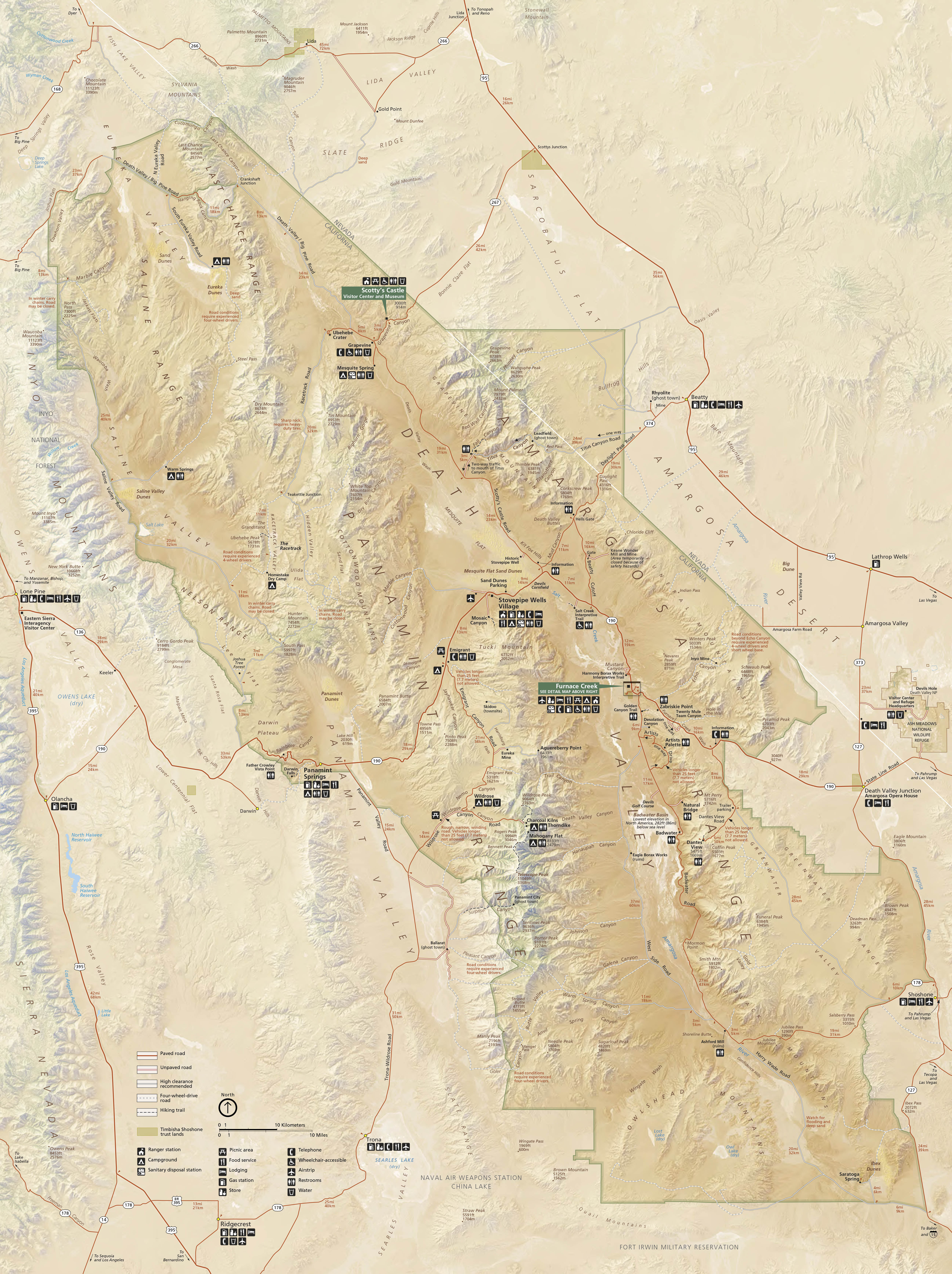
Here’s a 2019 document from the NPS that mentions warm springs “located in a remote northwest corner of Death Valley National Park, 35 miles from the closest paved road.”
Apparently, plans are underway to make these more available to park visitors.
I checked GoogleEarth and found a couple of warm springs at these coordinates:
- Palm Springs: 36.8128 / -117.7661
- Lower Warm Springs: 36.8057 / -117.7730
Note some “artwork” (rather crude stone arrangements) southwest of Palm Springs, and what is apparently a crude airstrip south of Lower Warm Springs.
These locations do seem to be within DVNP - park boundary is ~10km west.
@carrps Isn’t it? Seems to be inside it on this map. I know the borders of the park have expanded since it was first founded.
Those spots look lovely!
Reading the reviews for the springs, it seems folks either love 'em or hate 'em.
Must be. Like I said, it’s been decades for me!
Wow, it looks a lot more “developed” than back in my day. The one comment about the “regulars” did jibe with my memories, though.
Not mentioned yet of how fantastic the wildflowers are in the valley in a wet year. In a really wet year you can kayak Lake Manly like Huell Howser did in the Springtime in Death Valley episode.
Badwater, February 2016

I need to plan a visit for when the desert is blooming . . .
We do DV quite a bit. My daughter just got engaged at Mesquite Dunes, and afterwards we camped for a couple days at Mahogany Flats. Some years we go and do some heat hiking (not advisable, but we go prepared). Hottest was 122F*.
We like to do Darwin Falls whenever we go. Seeing a waterfall within the desert is just amazing.
Aguereberry Point is absolutely stunning. It’s a few miles down a very bumpy road, and looks towards Dante’s View. Every time we’ve gone we were the only ones there (The Harrisburg ghost town is on the way). I would advise a high clearance vehicle, but we have taken a car (slowly).
Titus Canyon Road is an amazing drive. Again, you would want a high clearance vehicle, but we sometimes see cars on it.
Mosaic Canyon is a nice hike, and close to Stovepipe Wells.
We always stop at the Father Crowley Overlook to watch for jets flying through the canyon, but have yet to actually see any.
For those that have never been, just driving around the park is like driving through a postcard. Pictures don’t do it justice. The lodging prices in the park can be prohibitive, but just outside the park in Nevada is a place called Longstreet Casino. It’s in the middle of nowhere and has cheap rates and good rooms. It’s also a 24 hour bar and casino, so there is that : )
*If you ever go to DV during the hot season, do not take the heat warnings lightly. This is the hottest place on earth and the heat is often fatal. I have seen people start to hike and have to turn around within 25 feet. If there is any breeze, it feels like a blow dryer in your face. People have died within sight of their vehicles. We look like we’re going on safari with lots of extra everything, and with very short goals.
Although you may still see jets at the viewpoint, I don’t think below-the-rim flights have been allowed since the crash in 2019.
Hell, we get that in Phoenix at 10 or 15 degrees cooler. When people ask what it’s like, I tell them, “Imagine you’re baking a batch of cookies or something and you open the oven door for a peek. You know how the heat rolls out and hits you in the face? It’s like that only it doesn’t stop.”
It’s pretty cool that the lowest point in the contiguous US (Badwater Basin) is only 90 miles from the highest point (Mt. Whitney). There is actually an ultra-marathon that goes between the two that’s held in the middle of summer.
Yeah, I love that the two points are so close (I thought it was 80 miles though).
That ultra-marathon only goes to Whitney Portal. All the way to the summit would be extra brutal!
I think it’s 84 statute miles, point to point.
Indeed: an additional 6100 net vertical feet, on top of the 8600 already done.
We were on a spring break road trip and had a day to kill before a concert in Las Vegas. We went up to Death Valley and took a little hike up Echo Canyon. There was an incredible view across the valley to Telescope Peak. It got dark as we took the dirt road back to 190. As we got closer to 190 we could suddenly feel our skin drinking in moisture. Turns out there was a little concrete ditch running along the road that they ran water down in the evenings. The place left a big impression on us.
I have a special fondness for Dante’s View and Echo Canyon. Years ago my dad and I rode dirt bikes into these two places. It was in winter, and had snowed in the mountains surrounding the valley. In Echo Canyon we rode on fresh powder.
We stopped near Stovepipe Wells on our drive to Mt. Whitney from Las Vegas in August 2016. I remember thinking how desolate it was for a National Park in the summer, and the heat warnings certainly made an impression. It was HOT, of course, but beyond that, I was surprised at how extraordinarily dry everything was. I’d just never seen an environment quite SO arid. Just, twigs that seemingly had not a single molecule of moisture within them. And it makes the ground and everything look so weird. It was a mysterious place, but I liked the feeling I had there, and I’d love to go back and actually do some hiking there.
Thanks for this thread!