Just to check things out, I went here to get a look at the current day/night map of the world. I saved that map, clicked on +12 to get a half day later map and saved that.
Flipping back and forth between them gave two congruences for the civil twilight curve. (No sunrise/sunset curve.)
One was in the central Pacific S. of Hawaii and the other was in the Congo. (The 12hr choice fixed things near the equator.)
So it would work today, sort of. Large margin of error. Possibly really large at high latitudes, which seems to ruled out. And really terrible, as noted, around the equinoxes which again might be ruled out.
I think part of the solution is to use the Sat phone’s ability to get the current time. So, wait until the Sun starts to rise (just the top). Turn on phone, get time. Turn off phone. Wait until the Sun just about finishes setting. Turn on phone, get time, make call.
If you on an island in the SW pacific in one of more numerous archipelagos, you’re still going to be stuck.
I could tell if I wasn’t in the northern hemisphere, and then nothing else from the stars if that was the case. Even in the northern hemisphere at best I could tell whether or not I was in the tropic. The sun would be much more help to me than the stars, and not that much anyway.
Not phoning before daylight is either a red herring or very significant, but I don’t know why the kidnappers would care. Maybe the position of the satellite or multiple satellites that pick up the call would reveal the location in the time before daybreak. The more calls you make the more the satellite positions should help.
If the phone can text, you could send a lot of info at different times of the day with one minute of battery.
I think if allowed two phone calls, you are great.
If limited to one call, I would first determine and set up W-E line and thus N-S line. This would tell you N or S hemisphere. Then I would wait for an international space station flyover and call during that and say exactly when it crosses the north-south line.
The ISS is bright as hell, and covers all temperate areas over the course of a few nights. I think this one call could get you a smaller search window than sunrise and sunset even.
I take it to mean that any knowledge about individual stars (or constellations) is unusable, but general astronomical principles are OK.
So, using The Dipper to find Polaris is out. But it’s OK to pick some stars, mark their directions, then re-check their locations every half hour or so during the night, determine what point they’re rotating around, and call the direction of that point Axis (we don’t know if it’s North or South yet)
Now draw a circle with Axis marked and divide it as accurately as you can. When you can see first light, you can mark East (perpendicular to Axis towards the light). If it’s winter in the northern hemisphere, the sun will rise south of east, and vice versa for winter, so assuming I remember the date I was kidnapped, as soon as the sun gets localized, I can mark North and South on the Axis line (and if I can’t remember the date, if I can remember where I was kidnapped, there’s a very good chance that the snowy night will let me make a guess about which hemisphere is currently winter).
Now (assuming the sun isn’t due East*) make the call, telling them “I’ve been kidnapped and need to be rescued. I’m on a roughly tropical island about a mile across with no other land in sight. The sun is just rising and it’s at an angle of X degrees south/north of East. Please hurry I hate liverwurst”
If it’s near the equinox, well, you may have to get latitude by waiting until noon and measuring the length of your shadow, since ‘sun rising due east’ won’t help locate you. Then wait to sunset so they get the moment of sunset and your length of shadow latitude
Stick a water bottle in the sand, call when it has zero shadow, which establishes exact local noon. Remember whether or not you saw the big dipper last night -so you can communicate north or south hemisphere, too. Given that it is winter in your home-hemisphere ( it was snowing), whether or not your un-shod feet are cold will shorten the line of local noon which matches yours, if you are in your home hemisphere. Mention the color of the wake luminescence, it could help narrow it down further.
Curious that you are instructed to wait for daylight to make the call. I cannot think of a Satphone that only works at daylight.
At daybreak I’d examine the sat phone for any identifying numbers or marks. Then I’d dial 1 (703) 482-0623 or 1 (202)456-1414, identify myself and issue very direct threats against the President and Vice-President. I’d throw in any id on the phone I was using and tell them it was a sat phone and that I had more information about the threat. Then I’d sit back and see just how efficient the NSA is.
That will only work if you’re in the tropics, and even then only on two days of the year.
The more I think about it, the more I think that the only valid solution is “The kidnappers have left me on some deserted beach somewhere. Track the location of this phone”. I’m pretty sure that (given law enforcement authority) that’s possible to do for any satellite phone, and it’s the only solution that doesn’t require any astronomical knowledge.
The thing is, calling at sunrise/set isn’t hard to determine, and doesn’t require any calculations (or even knowing the time) on your part – the people at the other end of the call are responsible for that.
Now knowing that the time of sunrise/set will determine your location does require some knowledge, but IMHO is allowed in the puzzle.
As mentioned in the OP 9and in the solution I sent in), I assumed the phone was’t trackable or else the problem is too easy (I’m not sure how trackable GEO phones are – certainly less so than LEO phones)
The main issue I have is the fact that it is salt water isn’t important (though makes you more finable than if you were in the middle of a rain forest) You could be in Lake Superior and my solution works.
Unless that is a red herring (salt water – herring)
Even simpler you could do this with one call in the morning.
When the person calls at sunrise it is h hours before local noon so you’ll need the equation of time also. This means they are h * pi / 12 radians away from the from the sun. There’s your longitude BUT since we know sunrise is located on a cosine curve (counting the Sun as 0 radians) we simply need to calculate cos(-h * pi / 12) and multiply by the appropriate amplitude, take into account the Sun’s declination and there you go.
To visualize this, look at a map of the curve of sunlight. It doesn’t look like a cosine curve but that is because of the scaling on a Mercator map at extreme latitudes. For now just fool yourself that it is a cosine curve. The curve represents everywhere the sun is on the horizon. You claim that from that first phone call you know the longitude right? You also know the longitude of the sun-solar spot. On our graph it is an offset so if in reality the sub-solar point is at 140 deg W and the person is at 170 deg E on our graph that means we made the mark on your at -50 deg. Ok back to the curve of sunlight map. You know your friend is at 170 deg E right? So make a vertical line and where it intersects the curve, that’s where your friend is at.
But Saint Cad, you don’t know what h is, especially since you don’t have any chronometer other than the phone itself. I suppose you could turn it on at sunrise just long enough to read the time and then turn it off, and then turn it back on at sunset, but that’s not really a big improvement over calling at both times.
(and yes, you can use the time of noon in place of either of those times, but it’s much easier to determine the precise moment of sunrise/set than of noon)
How would we be able to figure out what the local time is? Seems to me like at sunrise you could be anywhere along the edge of the sunlight curve, right? I don’t think you actually know what the longitude is just from the call, unless I’m missing something.
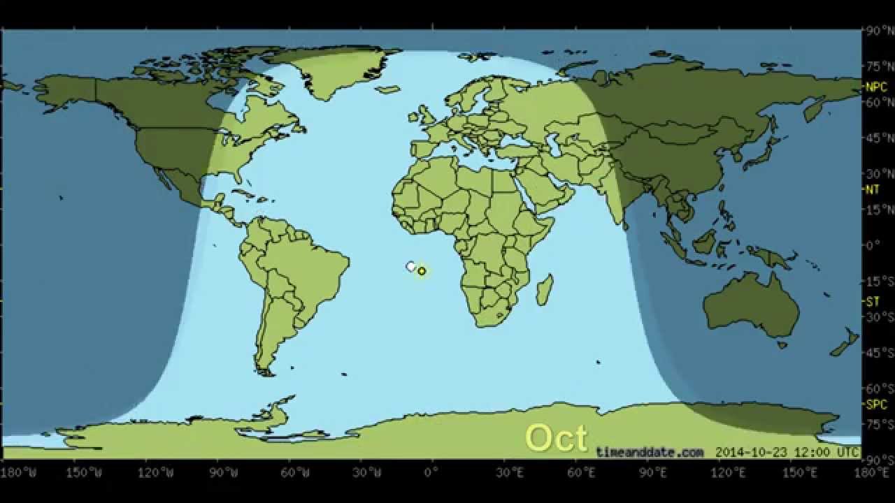
The receiver will know THIER local time. Lets say it is exactly as pictured. Since it is dawn they know you are somewhere south of Sri Lanka (or in the Barents Sea)
But I don’t see how that gets you latitude
Stick a water bottle in the sand, and as it gets to noon, trace the top end of the shadow with your finger in the sand. Measure how tall the shadow is, compared to the bottle.
Then at dusk, make your call.
“Help! I’ve been stranded on a tiny island. The sun has just kissed the horizon this very second. At noon, shadows were (some fraction) of the object casting the shadow. As I measured the shadow, the line curved clockwise/anticlockwise. Come get me!”
How precisely can you time noon/measure fractions of a shadow (uh, between 2/3 and 5/8)
Granted I don’t know how precise the length of day gets you (as mentioned, depends on location and time of year)
But someone already knows where you are, you just got to get them to give that information to your people.
Call you’re people(who are also not stupid) at day break and have them record the time and roughly describe your location so they have something to work with if the kidnappers fall through. Since they’re intelligent they could probably negotiate a deal with the kidnappers that involves your rescue.