There’s a sign in Darwin that says “Alice Springs 1500km”
Here’s one I’ve seen, from the other end of the road (near Barstow CA). I think I’ve seen other similar end-to-end distance signs but haven’t found any other pictures online.
At the eastern end of US 50 in Ocean City, MD, there’s a sign that says “Sacramento, CA 3073.”
Does the US have bracketed destinations for big places not on that road (but which you are likely to be travelling to)?
In Sydney, you might see something like:
GOULBURN 212
(CANBERRA 356)
ALBURY 590
MELBOURNE 876
Having worked a couple summers for the Indiana DOT (which has nothing to do with my current job), I can tell you that at least in this state, technically they are not “mile markers”, they are “reference posts”. In general they put one about every mile and they mark off about every mile, but they can’t always place them at exactly one mile each time (buidlings, other signs, etc, get in the way), so this is the reason that technically speaking, they are reference posts and not mile markers.
They serve a purpose, too, other than just being a useful way for people to know how far they are from a certain city. They use them to keep track of highway signs and cracks, potholes, etc. in the road. AGain in Indiana, at least, there is a huge list of thousands of points along a road and where they are in reference to the reference posts. For example, a line such as 187 + 0.52 - road sign would reference a certain sign at 0.52 miles from the reference post marked 187. They reference buildings, businesses, and many other things along the road in this manner.
Reference posts are always number from south to north and west to east (or “left to right”, “bottom to top” as you would think about it on most maps). They begin with zero at either the south/west state line or the beginning of the road.
I don't know where the point is referred to on road signs that give distances to cities. A few years back, my college roommate and I were traveling out west. To make it slightly more interesting, when we passed a sign to a major city being so many miles away we'd each simultaneously guess the time we thought we would get to that city. We'd try to see who was closer. We ran into this problem....when are you in the city? Across the city line? Downtown? I think we settled on just figuring the mileage on the odometer and using it. Hey, it was a long trip. Give us a break. Something had to break up the 20 hours of Tetris.There are a few signs I’ve seen here that list other highways as if they were cities. (Normally you’d see distances to highways only on exit signs.) An example is the Thousand Islands Parkway, which is written in yellow rather than white, either because it’s federal or because it’s a scenic route. Several distance signs also include ‘Bridge to U.S.A.’ in the same way they usually have cities.
Two other general questions about highway markers:
First, does anyone understand those emergency markers that are often placed along Interstates? They have a lot more numbers that a simple mileage sign (which you’d think would work just as well) and the numbers don’t seem to be related to the mileage.
Second, though I guess it’s slightly OT, are highway exits in your area numbered sequentially or by distance? I know most places are numbered by distance (as they are in Ontario and most US states I’ve seen), but I’ve seen some highway systems with sequentially numbered exits (such as Nova Scotia). This can get interesting when the highway is developed because they don’t re-number the whole highway every time an exit is added. So Highway 102 from Halifax, NS to the Trans-Canada Highway north of Truro has some examples of exits like ‘7S’ and ‘14K’ where a single exit on the original road now has five or six exits nearby.
If you’re really geeked up about signs, read the MUTCD (Manual of Uniform Traffic Control Devices). Most if not all state DOTs have their own, this is the FHWA version. The relevant section is 2E.36 concerning distance signs.
And MapQuest says you can do it in 2852 miles.
On a sumwhat related tangent:
My girlfriend used to live in Indianapolis, and I in St. Louis, so over the past few years I’ve driven on I-70 quite a bit. I’ve noticed that the distance to cities signs usually list three or four cities. On surprisingly many of the signs on I-70 West, you’ll see the distances to both St. Louis and East St. Louis, as in:
East St. Louis 92
St. Louis 93
The U.S. state of Virginia used to number their exits sequentially, at least on the federal interstate highways (e.g. I-64). I don’t know if they were unique among the other states in this policy.
About a decade ago they switched to the more conventional “by the mile” numbering system. For a couple years, exits were labelled with both the new number and the old — as in “Exit 118” on the main sign, with a smaller separate sign saying “Old Exit 23”.
They also renumbered their Washington beltway exit numbers a couple years ago, for the same sort of reason I believe. However, down around the south I-95 exit, there are some peculiar exits with three digits, stuck in the middle of the normal sequence. I don’t know what that’s about.
It’s 12 miles to Exit 118, Old Exit 23, 3rd offramp from where I am, and from there I take 41st Avenue to Third St, address 181 Third St. (Brain bursts.)
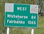
There’s a sign on I-25 in Albuquerque that has the distance to Denver. I don’t remember exactly what the distance posted is, but it’s definitely over 400 miles. I haven’t driven around 25 and 40 looking for signs, but I’d also be willing to bet that there are signs that would give you the distance to Flagstaff, Las Cruces (and maybe even El Paso), and probably places on 40 in Texas or Oklahoma.
Living about 30 miles from Barstow, CA, there is a sign with the mileage from the beginning of I-40 to the terminus in Wilmington, NC which is ~2735 miles, and it gets stolen on a regular basis.
Also, in Barstow, there is an intermediary mileage sign for Salt Lake City, Utah which is 576 miles.
My bad…2554 miles
It’s a brand-new sign (well, in the last six months or so). When you get on the QEW from the 405 there’s a mirror sign saying “Toronto 106 km.” After you pass the 403 interchange past Hamilton there’s a sign saying “Toronto ?? km.” (OK, by that time I’m paying more attention to the traffic.)
Actually, I have no idea why that sign you mention was put up. Less than 500m before it stands a sign which reads in part “Niagara Falls 115 km.”
OK, I’m only posting this because I can’t get to sleep.
According to the misc.transport.road FAQ, the longest “conventional” mileage marked on a BGS (that’s “big green sign” in roadgeek-speak) in the US is 1007 miles, the distance to Los Angeles from a sign on I-40 in New Mexico. In second place is a sign in east Texas marking 857 miles to El Paso on I-10. Third place goes to this sign, marked in kilometers here.
Just for fun, here’s a “non-conventional” sign from the Upper Peninsula of Michigan which gives the distance to Florida. (It’s the second picture from the bottom.)
I could have sworn I saw a documentary on Boston’s big dig that showed, as they opened part of (I think) the I-90 westbound (or maybe leaving Logan airport), they had a sign giving distance to Seattle, since you could now drive non-stop interstate highway Boston <-> Seattle.
Awesome URLs, Duke. Thanks!
Driving south on I-55 in Illinois you’ll see this, too. About 10-15 miles south of Springfield there’s a sign that says something like:
East St. Louis 88
St. Louis 90
My WAG is that they include E St. Louis because it’s the last exit in Illinois and St. Louis because it’s the first exit in Missouri. That they’re only two miles apart is a matter of geography (there’s that river, ya know…).
I suppose other highways at state border crossings list the town with the last exit in the current state and the town with the first exit in the next state, only they don’t seem as weird because there are miles and miles of empty space in between them. IOW, going from Illinois into Indiana you’ll see signs like this:
Easternmost Illinois town with an exit: 25
Westernmost Indiana town with an exit: 44
… because there are 19 miles of open road with no exits between those two towns. Of course IANAHighway engineer.
I don’t know about most cities but in Lexington, KY there is a zero mile marker at City Hall that says something like “distance to Lexington to be measured from this point in every direction.”