In Hamden CT there are 1st through 4th streets, each all of two blocks long, and no higher numbered streets.
The start of the numbered street grid on the West Side is an oddity in itself: West 3rd, West 4th, Washington, Waverly, West 8th.
In Brooklyn, the streets numbered “West [number] Street” are all located in the Gravesend/ Bensonhurst/ Coney Island area - except for one stretch of West 9th Street running through Red Hook, several miles away.
The Middle East was mentioned, and I believe it is Tel Aviv, Israel, of all places, that is known for that sort of thing. The streets have normal names like George Washington Boulevard, Zamenhof Street, Rabindranath Tagore Street, etc., and then out of nowhere there will be the odd 668th Street or 1184th Street.
China: some cities are (mostly) on a grid system, but they do not use numbered roads IME.
Ring roads however may be numbered: 1st ring road being the smallest / most central
Another odd one from Australia.
In Adelaide a very few suburbs have streets with number names. But spelt out. Sometimes called avenues. They run First Avenue through to Tenth in St Peter’s, First St through Eleventh in Bowden. These suburbs were some of the earliest laid out in the city. Bowden was a working class suburb with tiny worker’s cottages on minuscule lots. St Peter’s, professional class with some serious sized homes on large lots. These suburbs would have been designed with intent for their expected residents. So there just might have been a certain amount of class snobbery about the distinction between avenues and streets. The avenues are at least tree lined.
Hilariously an adjacent suburb to St Peters is called College Park. Streets with names like Eton, Harrow, Rugby.
Did they stop before they got to Barber or Clown? [Simpsons joke - but sadly no GIF]
MK was a new town laid out on a grid, hence all the roundabouts which it is famous for. All of the main routes have a H or V designation as well as a name. H for horizontal for East-West routes and V for vertical for North South routes.
Another new town with numbered avenues on a grid is Harlow. But they all have alternative names too, which sometimes get changed.
Not numbered streets, but same basic idea: The German city of Mannheim has a grid plan that assigns coordinates (such as K4 etc) to blocks rather than names or numbers to streets:
I appreciate all the examples of cities and localities that have “a little bit” of numbered street naming amid a wider scheme of named-street naming. It’s counter to my experience and interesting to learn about.
I’m especially amused by the article you shared, surveying the practice of calling a central avenue “main street” in various places — because I myself live on Main Street.
My house address is on “rue Principale,” which is literally “main street” in French. ![]()
In Israel, Arab towns traditionally don’t name their streets, so the government issues them all random 4-digit codes for administrative purposes. There were quite a few nameless street in Jaffa when it was consolidated with Tel Aviv in 1950, but over the years most of them were given names, and now there are only a handful of numbered streets left.
As an aside, there is a fairly major street in Tel Aviv called “The Four” (“Ha’arba’a”), but that’s not a numbered street - it was named in honor of four militiamen who were killed there fighting the British in 1946.
Tang Hall, in York, England, has numbered avenues; First Avenue up to Ninth Avenue.
However, they are distributed almost at random around this suburb, not in a grid pattern at all.
Heh. Toronto has a Main Street too, only it’s not Yonge Street, which really is Toronto’s main street. It’s a nondescript north-south street, that people only remember because it has a subway station, named, unsurprisingly, “Main Street.”
In my experience, in the case of the most famous numbered grid of all - Manhattan - it is not that unusual to spell out the numbers. It’s more commonly done for the avenues (I think “Fifth Avenue” is more frequently used than “5th Avenue”), but I’ve also seen it for streets, in particular the more important ones, such as Thirty-Fourth Street.
This goes back to antiquity. When the Romans founded a new town in a province, they’d typically lay out a grid pattern, with the north-south streets called cardo and the east-west ones decumanus. The most important of these were designated cardo maximus and decumanus maximus (and very often, the town’s main forum would be located at their intersection).
Lots of interesting examples in the comments. Has anyone ever run across a ‘fractional’ numbered street - something like 2-1/2 Street? As my home town Providence, RI, USA grew rapidly in the 1800s, a lot of new houses got 1/2 numbers between the existing buildings, most of which got renumbered in what must have been a confusing period in the early 1900s…
My area has some of that, but it started the other way around - the streets were originally numbered, but developers and sometimes town councils slap names on them, probably out of a sense that feels more “upscale” (and for developers try to up prices on property).
Detroit has its “mile” streets - 6 mile, 7 mile, 8 mile, etc. They are (surprise) 1 mile apart. But some of them aren’t referred to by their numbers - 1 mile, for example, is Warren Avenue.
I think U2 dedicated a song to that place…
The Detroit area has some “1/2 mile roads” Rather than boring everyone here’s a [link] (Mile Road System (Michigan) - Wikipedia
Oh, and for maximal numbered street confusions - Chicago not only has numbered streets, it also have very similar named numbered streets right next to each other. One is called “street” and the next “place”. So you can have 66th Street and the next one over if 66th Place (as completely random examples). Hilarity occasionally ensues.
Indeed. I mentioned elsewhere I recently explored Ostia Antica accompanied by an archeologist, and this was one of the things he talked about.
You can see the layout on reconstructed maps:
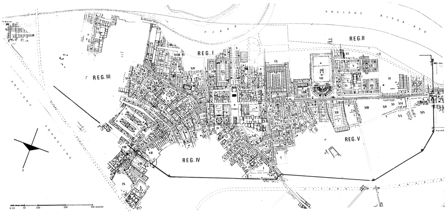
But there’s a wrinkle in this specific case. It wasn’t simply founded as a new colony; it was a pre-existing settlement, with probably a thousand years of occupation before the Romans formalized control. So they had to tear down a bunch of stuff and try to reorganize the city infrastructure in order to impose their preferred layout, and even then geography and resident habits and behaviors conspired to create continuous drift away from the preferred model.
It’s great fun, walking around an ancient city, looking at the traces and shadows that illustrate people just bein’ people.
That is the norm in the 3-county Greater Miami metroblob.
Numbered “Streets” run east-west. All of them. With roughly 1/5 mile between numbers. But in a residential area, that’s not a dense enough road network; the lots would be too large. So between each “street” they insert a numbered “court”. So 1st street, 1st court, 2nd street, 2nd court, 3rd street … If they still need more density, a “place” is wedged in there after the court. 1st street, 1st court, 1st place, 2nd street, 2nd court, 2nd place, …
Meanwhile numbered “Avenues” run north-south, with numbered “terraces” in between and if extra density is needed, numbered "way"s. So 1st avenue, 1st terrace, 1st way, 2nd avenue, 2nd terrace, 2nd way.
As I’ve written about before, the logic also extends in 4 different quadrants from the origin. So you have an east and a west 1st ave that runs north-south, and a north and a south 1st street that runs east-west. So 4 intersections of 1st and 1st.
In the few places that got the full density treatment there will be 36 intersections of 1st and 1st. Surrounded by 36 more intersections of 2nd and 2nd. Pretty quickly you learn that a valid road name is “[north/south] [east/west] [number] [type]” and nothing less. Leave off any part and you’re lost. “South east 10th street” or “north west 13th terrace” is valid. “North 12th” is not.
Oh yeah, don’t forget to include the town name, because each town has their own origin and the numbers radiate from that point and therefore reset at each (often invisible) town boundary.
Of course modern (e.g. post ~1970s) construction of enclosed subdivisions does away with all that. So you’ll drive on major numbered streets and aves to get to the entrance to e.g. “Happy Acres”, then once inside that subdivision all the streets are curvy and have cutesy names on some common theme.