A friend of mine made a short film set in WWII, and I did the visual effects for it. We had a scene where a plane flies from England to France and I had it going from right to left. It was pointed out that this was round the wrong way, but by then it was too late, so I kept it in.
I had no idea that there was this convention of left-to-right for west-to-east, and I’m not convinced even now that this is true, and no such convention exists. It depends on too many factors and as long as it’s internally consistent, it doesn’t matter.
I think the other similar convention of good guys on the left and bad guys on the right, because of the convention of how we read makes it “feel” correct, is also nonsense if you actually look into it.
This whole notion in the OP about this supposed “convention” just seems ridiculous to me. What is the convention for a southbound flight? Should it be depicted flying vertically down the screen?
The convention applies to what’s at the top of a map. A movie screen is a depiction of real life, not a map. In real life navigation, you rotate your map so that N on the map points to actual N. You rotate your map to align with reality, you don’t rotate reality to align with your map.
The camera could always just be on the other side of the plane. Unless the sun is setting in the wrong direction, or there are identifiable landmarks below which are in the wrong place, I don’t care from which side to which side of the screen the plane is shown to be flying.
I’ve never heard of or noticed this supposed “convention,” and unless there was some obvious landmark or astronomical error (like leaving on a westbound trip in the morning and flying into the sun) it would never occur to me that a plane was flying the “wrong way.” But…
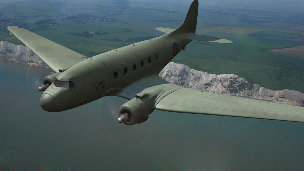
Exactly. In GuanoLad’s example (assuming the plane is flying more-or-less east), right-to-left would only be wrong if (say) the white cliffs of Dover were in the background.
Right, so the people who questioned the shot were probably not basing it on the alleged “convention”.
Was the final destination actually Calais? If not, a southerly course (which looks like what you depicted) still takes you to France. Unless it’s a small single-engined plane flying low, an aircraft is more likely to take a direct track to the destination to save time and fuel, rather than trying to minimize the distance over water.
I’ve never really got to grips with asking people who do this how they model the relationship between the map and reality. Suppose you’re driving, heading SE and you see a major landmark on your left. The track on your map shows you moving diagonally toward the lower right, and on the map the landmark is diagonally up and to the right of your track. How do you relate what you’re seeing in reality to what you’re seeing on the map? Do you do any kind of mental rotation, or is it just automatic and unconscious that left of the road you’re driving on corresponds to diagonally up and right on the map?
He did say that it was due to the convention, but maybe it was more than just that. I don’t know, I just stuck the camera that side because it had to be one side, why not that one? It’s not like it’s wrong, it just isn’t facing northwards from the equator. I still don’t see why that should be the way. It seems ridiculous to me. Nobody does this with cars, do they?
They had to work with what they had, and there’s not a lot of footage available. So they did the best they could, figuring only the most anal retentive viewers would care.
I mentally rotate the map. I don’t find it difficult. It doesn’t matter to me which way the map is oriented in relation to the way I am facing. In fact, it doesn’t matter to me whether north is at the top of the map or not.
The plane flying from right to left in the movie wouldn’t bother me at all.