As is emerging from the many responses, by the late 1950’s you could drive limited-access through most of the Midwest/Northeast corridor, roughly from Chicago to the Northeast. Roads were either under construction or on the drawing board in the farm states.
Beyond that, in the deep South or the intermountain west, good luck. The problem, of course, is that states with the wide open spaces had more miles to cover and less of a tax base to cover them with. And of course, the deep South was still poor at this time.
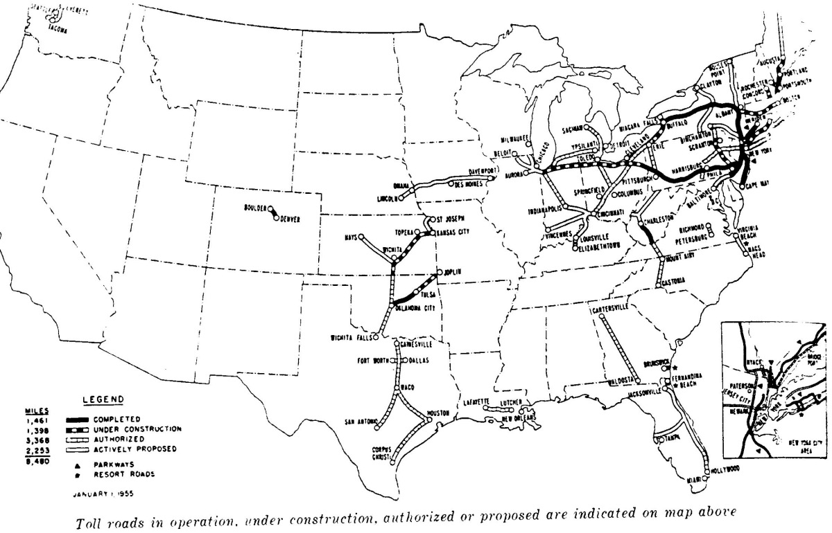
This was a rerun of the situation with respect to paved highways circa 1920, as chronicled in the book American Road–decent roads as far west as Chicago, and crap after that.
I can’t perfectly agree there. The very fact that it was needed was because of the lack of national-scale transportation infrastructure. I wouldn’t exactly say parochialism, myself, but the absense of long-distance high-speed trnsit corridors to move people acorss the nation was certainly viewed as a weakness.
This is sort of an urban legend. It’s true that when Eisenhower was young he participated in a famous military exercise, the Transcontinental Motor Convoy in 1919 that showed how bad the roads were in America. And he did appreciate the autobahn system in Germany.
But he came late to the party, as so many of the posts in this thread have shown. By the mid-1950s it was obvious to most Americans, and an article of faith to traffic designers, that the way to transport cars was to avoid the need to have them slow down and pass through city streets, whether in big cities or small towns. This was believed true not just for interstate travel but for the increasing suburban commuter traffic that funneled people into city centers. City streets were clogged past capacity almost everywhere.
However, the politics of the system were such that cities got a much smaller proportional share of Interstate funds than were their due. Most of the early funding allocations went to rural areas, where traffic needs were less but those in Congress were powerful. The intricate city beltways and loops were more a product of the 60s and after.
None of this was intended in any way to support military travel. It may have sounded good as a reason to spend money in the beginning, but it was no more than a sound bite for public consumption. The system was put into place for cars and trucks, not military vehicles, and nobody, including those in the military, ever seriously professed otherwise.
A couple of years ago I read an interesting book, American Road, about this trip. I recommend it if you are interested in this subject. On a personal note, I was fascinated with the speed at which automobile travel improved - just 20 years after the military convoy that took months (and travelled with their own tow trucks), two of my widowed great-aunts did it on their own in a 1937 Chevy.
The Overseas Highway (U.S. Highway 1) that goes out to the Florida keys was built in the 1930’s. One of the longest bridges when it was built, the Seven Mile Bridge connects Knight’s Key (part of the city of Marathon in the Middle Keys) to Little Duck Key in the Lower Keys.
Incredible engineering feat that cost 200 Veterans their lives.
I would beg to differ. One of the principal initial reasons given for the Interstate Highway network was its value in transporting convoys and miliary materiel rapidly from place to place across the country. This also helped justify it to the strict constitutionalists of the time, as being valuable to the national defense. By law, military convoys have, or at least once had (not sure if it’s still in effect), the right-of-way over all other traffic save emergency vehicles on any highway funded by the Interstate system.
The lyrics to the famous song mention (wiki) "The lyrics read as a mini-travelogue about the major stops along the route, listing several cities and towns that Route 66 passes through, viz. St. Louis, Missouri; Joplin, Missouri; Oklahoma City, Oklahoma; Amarillo, Texas; Gallup, New Mexico; Flagstaff, Arizona; Winona, Arizona; Kingman, Arizona; Barstow, California; and San Bernardino, California. Winona is the only town out of sequence: it was a very small settlement east of Flagstaff, and might indeed have been forgotten if not for the lyric “Don’t forget Winona,” written to rhyme with “Flagstaff, Arizona.”
None of those (we’ll exclude Winona as it was just there to rhyme) " towns sprung up because of the highway". Gallup, Barstow, Flagstaff, Kingman, all were railroad towns.
Oatman AZ might count, except it was a mining town too. Grants NM is close, but it started as a RR town. Glenario NM/TX was a tiny burg that pretty much rose and fell with Rte 66.
I don’t see how this differs from what I wrote. The key is your word “initial”. I would need cites that said that once the network started being built traffic engineers cared about military convoys. Or that even the military cared about military convoys. The Interstate had its own logic and once people got a taste of it they didn’t need more justification.
By the way, thanks to all who provided responses here – they’ve been very interesting.
I do know that during the Cold War, convoys headed for Fort Drum (which was the major East Coast reserve-training facility, AFAIK) were said to have priority in the use of I-81. And that the original bill made reference to National Defense in the title and intent. Beyod that, I’ve got nothing.
The Bronx River parkway was limited to passenger cars only and had cross traffic eliminated in 1924 (Wixom, Charles W., ARBQ Pictorial History of Roadbuilding, 1975)
Planning for the controlled-access Merritt Parkway in CT began in the 1920s (ibid). The Pasadena (Arroyo Seco) Freeway was started in 1940. (ibid).
The Pennsylvania Tpke opened in 1940, partially on the route of an abandonded railway line that was never built. (ibid)
The U.S. Interstate System, now officially named the Dwight D. Eisenhower System of Interstate and DEFENSE Highways, (my CAPS) was conceived by President F. D. Roosevelt in 1944 and became a reality in 1956. Its design standards to this day allow for the transportation of missiles by trucks, under bridges that must have at least one route through a city with at least 16 feet of vertical clearance. Its originally planned routing was to connect cities of 50,000 or more population and major military bases/establishments.
The Vanderbilt Parkway (or as Wiki calls it, the Long Island Motor Parkway) opened in 1908 and claims to be the first roadway designed exclusively for automobiles as well as the first to use overpasses to eliminate intersections.
However, as the article explains, you could turn left across oncoming traffic, so while it was limited access it wasn’t entirely what we think of as a superhighway.
And to be fair, it was closed in 1938, prior to the date in the OP.