OP username/topic alert.
Somebody had to say it.
OP username/topic alert.
Somebody had to say it.
I actually live in Bloomington, (but on a full avenue, not a half street).
The Twin Cities is built with rectangular blocks, 16 short blocks and 8 long blocks to the mile. So what do you do if you want to put a street in the middle what would normally be a long block?
The other option is to name the extra street something random.
In Calgary, we mostly have numbered streets and avenues in the original areas, that continue outwards with direct lengthening of those roads. Streets north south, avenues, east west.
In the older portions of town, a road added in between is often given a letter extension. My workplace is on 8A Street. Between 8th and 9th Street.
You can go a step farther than that. There are no numbered streets on the north side in the city proper, as far as I know. (While double-checking that info, in case there was a numbered avenue or something, I did find an oddity that may be of no interest to anyone but Chicago geography-philes. Apparently there is a 63rd Parkway here, which runs between 61st Place and 62nd Street (!?) )
Maybe it was a compromise between the people who wanted to name it 98th Street and the people who wanted to name it 99th Street.
Springfield, Illinois has a 10 1/2 Street. Not surprisingly, it runs between 9th Street and 11th Street, kinda diagonally through an industrial area, although there were a few houses there at one time (there may or may not be now, I haven’t looked).
A lot of County Roads here in Colorado are 1/2 (aka .5)
Lots of places have addresses that include 1/2 or even 1/4, though I can’t remember ever seeing a 3/4. For about six months back in 1996 I lived in a “1/2”, which was the guesthouse to the house that didn’t have the fraction. in the address. Curiously, the main houses on these properties are often not much bigger than the guesthouses. In the L.A. area you find a lot of these places around downtown Culver City and Glendale.
Most places in the U.S. (I assume all but local variants may exist) have the properties in their jurisdiction laid out on plat maps, collected in a plat book. The plat map shows every individual parcel of land, whether or not they are collected together to build on.
Street fronts are assigned numbers. For most purposes, these numbers determine what the address on the building is. If the parcel is numbered 2237 North St., then you can’t give a new structure on the back of the property the number 2239. That’s why they get the 2237 1/2 designation.
It’s seldom as simple as this in practice. A building that covers several parcels with several numbers can take on any of those numbers. Corner parcels can have two numbers, one for each street, and either may be used. Major buildings can get their own address, like One Dominance Square. I assume that’s a legal fiction and 2237 North St. may be the real address but I never did figure out how that worked. The USPS cares about this a lot and will stomp on people who don’t follow the rules.
Plat books are absolutely fascinating to look at. They’re like an archaeological x-ray of what’s under buildings. If you can find one in a local library, say, take the time to look carefully at a couple of pages.
My grandparents owned and lived in 2130 XXX St. and owned and rented out 2130 1/2 XXX street.
Los Angeles has a lot of numbered streets that run something like 129th St, 129th Ave., 130th St. 130th Ave. …
When going north through Los Molinos, California on California Highway 99, the street names are 6th Ave, 7th Ave, 8th Ave, 9th Ave, 61st Ave. I have no idea why the big jump in numbering.
The avenues in Galveston Tx were originally platted as Avenue A, B, C… up to Avenue M. The next avenue is Avenue M 1/2, then Avenue N, N 1/2, O …and so on until the last one, Avenue U. I’ve heard a claim that this was done because the lots were originally twice as deep as they are now, but looking at a map it’s pretty clear that they had to do this or else they would have run out of letters before reaching the beach side of the island.
I was on 13 1/2 Mile Road a few weeks ago. Yes, it struck me that Macomb County street namers must be some lazy SOBs ![]()
For two inglorious months, I delivered pizzas in Gainesville, Florida. Being a college town (the University of Florida is located there), there are lots of rental properties. Sometimes, a delivery address would have a 1/2 designation, and that meant it was a little cottage behind somebody’s main house.
Also, in Gainesville, I learned that APRL (i.e. Avenue, Places, Roads, and Lanes) meant North/South, and STD (i.e. Streets, Terraces, and Drives) meant East/West. It’s been about 17 years, and I may have the directions mixed up, but those acronyms have stayed with me.
In Washington DC there’s 9 1/2 St NW near Howard University that dead ends at the rear of the African American Civil War Museum, then downtown there’s 13 1/2 St NW off Pennsylvania Ave which ends at an L-intersection with D St NW.
There’s also Half St SE next to Nationals Park. It’s between South Capitol and 1st St SE so it really is 1/2 St.
For years my address was 608 1/2 9th St. It was a very small house (about the size of a studio apartment) behind 608 9th St. People used to call it a “mother-in-law” house. I assume it was common practice at some point in history to build a tiny house behind your own to satisfy your wife’s mother but not have to live under the same roof.
It was a whole, separate house but the plumbing between the two houses was somehow connected together, enough that there could only be one water meter for both houses. I paid my landlord a flat fee for water each month with rent.
Would be known as a “granny flat” here, and it would be given an orthoganal number: 608/1, 608/2 If a larger block was subdivided, there would be 608/3 608/4 etc
In a book about telephones, Gary Owens gave a Yellow Pages address as “0 W. Las Tunas Drive, San Gabriel [California].” 
If you’re really lucky, the assessor’s office of the county you’re interested in will make all this information freely available online, as does the County of L.A.
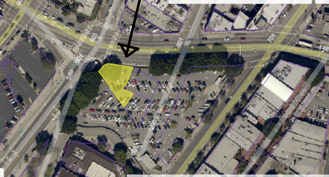
Here’s an overhead view, from their website, of what today is mostly a vast parking lot used by those wanting to visit Olvera Street, area museums, or the old Plaza Church. Although it’s been many decades since there was a building there, the Assessor’s database still marks it as its own parcel (highlighted in yellow).
From a link on the same page, here’s the plat map, showing a couple of adjacent parcels as well.
And if you’re still luckier, you can find an early 20th Century Baist or Sanborn map of he locale you’re researching. This screencap is from the online Rumsey Historical Map Collection Here’s our parcel in 1921, when it was marked on the map as a hotel.
We notice immediately that just about every second building seems to be a hotel, though given the nature of the neighborhood at the time these were fairly threadbare if not run down. Mostly they provided shelter to the working class residents of the neighborhood, which was very pedestrian/transit oriented and mixed use. I’d say the “hotel” part really applied only to the upper stories, while the ground levels were mainly rented out as stores and other businesses.
In the early 1950s the neighborhood was almost completely depopulated with the coming of the freeways, urban renewal, and overall repurposing to be car-friendly and everything-else-unfriendly.
In the first two maps, the parcel shape betrays the old street alignment even though this was changed some time around the early 1950s as well.
Here in Reading PA., we have a bunch of them. They are much shorter streets, some are only 3 or 4 blocks long.
38 1/2 St in Austin is a fairly significant road (it has its own interstate exit.)