And 100,000 lightyears wide. Which means it’s basically flat. If you’re traveling 10,000 light years thataway and 200 light years up, your vertical angle is going to be quite small.
When you’re talking about the Milky Way, remember that everything is in constant motion, the disk varies in thickness and gradually thins out at the edges, and the whole thing is surrounded by a halo of star clusters. There is no distinct boundary to it (the existence of “energy barriers” notwithstanding).
Almost any measurement you make of the Galaxy can only be expressed as “average.”
Assuming that the vast majority of solar systems lie in the Galactic plane, yes. On the other hand, here at Zero–Zero … Zero (?) we don’t know how many are clustered around our zenith and nadir.
Assuming you’re looking down on the Galaxy in a polar projection and you’ve set an arbitrary firm radius of 100,000 light years, Sol’s position in terms of “latitude” would be … what, 30 degrees?
You’d also need to establish an arbitrary plane running through the average thickness of the disk to mark the zero point of declination above or below it.
And it’s highly unlikely that Sol would lie in this plane, so this coordinate would not be zero.
God, I love trying to figure out stuff like this! :o
Sorry; diameter, not radius. Mea culpa! :smack:
The Federation standard galactic prime meridian is a plane (perpendicular to the galactic disc) which intersects the center of the galaxy and Sol. Headings are measured relative to that.
I suppose there would also need to be a defined plane to measure vertical angles against. I don’t know if the Star Trek writers ever put any thought into it. I suppose you could pick a star out near the edge which is close to the midway point through the disc and declare another meridian which is the galactic standard plane. All your headings are then ABC mark XYZ where ABC is the angle from Sol and XYZ is the angle from the plane.
None of the deliberate straight-line courses of Star Trek vessels seen on screen–anything “set” at the helm–were anything like this distance, nor even a significant fraction of the 1,000 LY galactic thickness. Earth to Vulcan was about 16 LY, for example. The most distant place Picard’s Enterprise visited, IIRC, was about 2,000 LY from Earth, presumably one stop of many on an irregular course.
Basically it is two circles perpendicular to each other and you are giving the degrees on each circle separated by the word “Mark” which allow you to create a heading in any direction.
That’s correct, if you’re viewing the Galaxy as a sphere. In two dimensions, the line of that plane runs through the plane of the disk and passes through Sol.
The problem in thinking of the system as a sphere is that it has no naturally defined radius (or diameter), and you’re traveling inside it, rather than along its surface (as is the case when navigating on Earth). The mathematics of this escape me, though I assume it’s a matter of employing trigonometric functions (none of which I remember from high school).
I disagree.
It would have to be defined relative to some base coordinate reference. (Waaay oversimplifying) Let’s say the galaxy is a sphere of unit one radius. Earth is at 1,0,0 coordinates, and is considered zero degrees on the coordinate map, with the circle counting anti-clockwise. Vulcan is at 0,1,1, (and the galactic coordinate is 90 degrees). To go between them, you would set a true course (galaxy-wise) of 135. The up and down difference in the galactic plane would be the “mark” angle; in this case, Mark 45. If you were at the galaxy center, your true course would be 90 degrees mark 45. To go back home from Vulcan, your course would be 315 degrees (or -45) mark 315.
The navigation coordinates given in the show have to be relative to the galaxy in order to make sense. If it was by direction of ship travel, it would be way too complicated. You’d still need to know where you are in the galaxy, and then add the constantly changing attitude of the ship. (In orbit around a planet - “Checkov, plot a course to Starbase 12”. "Aye Aye, 123 mark 15, no wait, 122 mark…no, 121…dammit!)
How anyone keeps it straight is the big mystery. If you don’t know where you are, you don’t know how to get where you want to be. On earth, you can use the compass or GPS to know where you are. Does Starfleet have fixed navigation buoys floating all over? Some sort of galactic positioning system?
That can’t possibly be correct. The Federation alone spans a large chunk of the Alpha Quadrant, not to mention all of the non-federation places that the Enterprise visited. If you were right in the middle of the galactic disc, halfway between God and the rim, traveling across half the alpha quadrant (1/8 of a circle) would be around 20,000 lightyears.
I suspect that the “number mark number” system is probably a normal space system used when under impulse power. In that context (within a planetary system or at least not at warp), a relative to the current heading system makes sense, especially if the ships are powerful enough to just power around the system without having to worry about transfer orbits or anything like that.
If going between planets, I really doubt the captain or navigator would be giving angles in the first place. It would be more like “Navigator, plot a course to Starbase 383.”, and he’d fire up the nav computer to figure out where that is in relation to the ship and point the ship in that direction, as well as make sure they’re not going to get anywhere close to anything while at warp. So it might be a slight dog-leg course to avoid a star-system or nebula or something.
I would think that in space, “straight up” has precisely as much or as little meaning as “elevation angle”? ![]() Any spaceship has a front, back, top, bottom, left and right. “Straight up” seems perfectly clear to me. It may only be relative to the spaceship’s orientation, but that doesn’t make it meaningless.
Any spaceship has a front, back, top, bottom, left and right. “Straight up” seems perfectly clear to me. It may only be relative to the spaceship’s orientation, but that doesn’t make it meaningless.
And if you flip your spaceship upside-down, straight up is now in a different direction. That’s why you need some kind of navigational system with fixed points from which you can reckon things.
If your spaceship doesn’t have artificial gravity, “straight up” is completely meaningless.
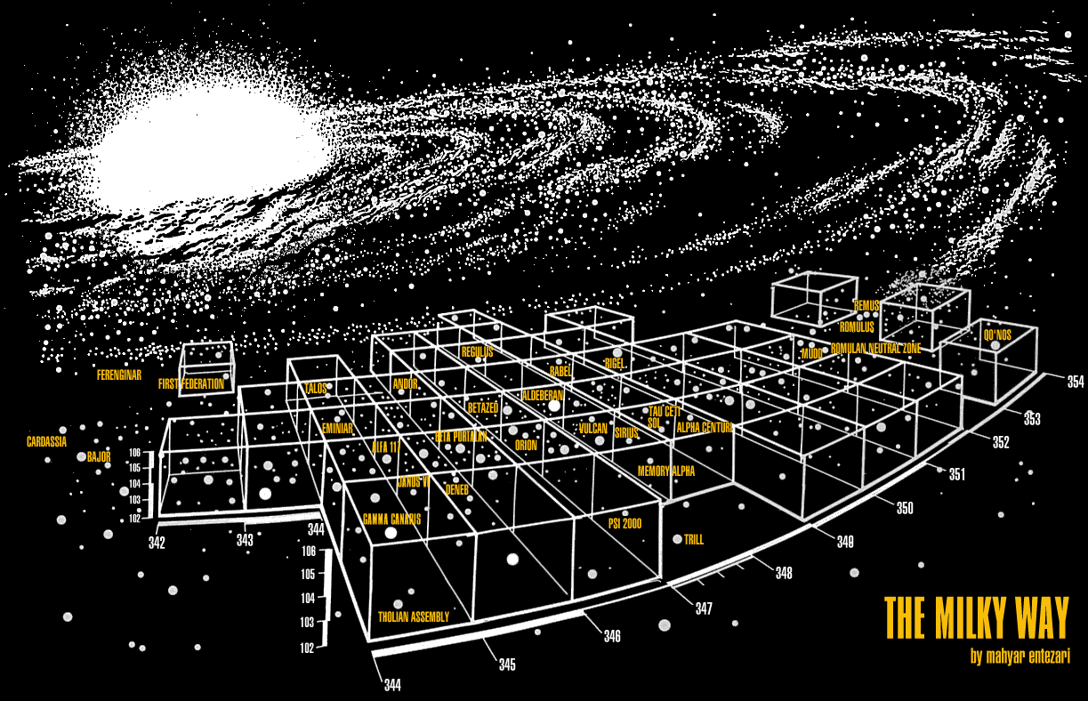
The Federation straddles the Alpha/Beta line, but there has to be a very considerable chunk of each that is outside Fed space. Geekier Trek fans than I have written down every mention of real stars and relative fictional locations and point-to-point distances from the shows, trying to work out the astrography (Cardassia is 5.25 LY from Bajor, which is 65.5 LY from Ferenginar, so on).
Here’s one interpretation. Quite a bit less than a quadrant, there.
I thought “mark” was a mere oral cue to separate two different numbers in a coordinate system.
I’m almost certain that I recall a scene from TNG where Wesley explains it this way.
I was watching Encounter at Farpoint just last night and that’s exactly what the Enterprise did to try esacpe Q’s net.
On Earth, headings and bearings are given from the perspective of your vehicle’s three-axis control system, whether you’re on the surface, below it, or above it.
Your geographic location is given in terms of latitude and longitude (and depth if you’re below the surface, or altitude if you’re above it, mean or otherwise).
When Kirk says “New heading, 111 mark 14” or “Bearing, 20 mark 10,” he means relative to the ship’s current position and orientation.
If the ship has a bow, a stern, a port side, a starboard side, a keel, and a dorsal spine, you do have a sense of “up and down, sideways, backward and forward,” regardless of your external frame of reference.