The route I take home, Friday evening, about 5ish.
>> They chopped temporary routes through the Darien gap, winching the vehicles across bad spots, and rafted across the Atrato Swamp in Colombia.
I think we can safely classify that as a discontinuity _
What about the ancient Silk Route, all the way from China to Europe?
This map indicates there are continuous road connections from Spain/Portugal across Europe through Russia, and on into China, reaching the East China Sea. At least from this map, it would appear that there is no direct road connection to Vladivostock. However, if there were it would seem to be possible to drive as far east as Magadan on the Sea of Okhotsk.
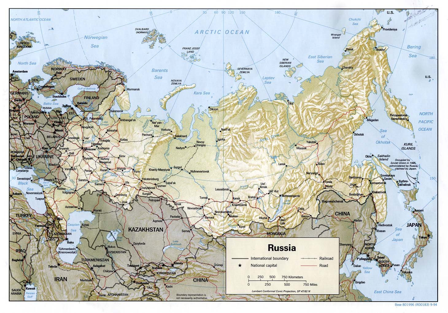
That route looks to be at least 7,000 miles/11,000 km, probably much more.
It would theoretically be possible to drive from South Africa to either Manchuria or possibly Siberia. If one is looking for the longest connected system of roads, that’s got to be it.
I seem to recall that shortly after World War II a highway was completed through Pakistan, Iran, Iraq and into Turkey. For a brief period of time it was apparently possible to drive from Spain to India, and from there through the Ledo Road to central China. Political instability has since made such a journey theoretical at best, even if that connecting highway has been maintained.
Probably not a single road, but a very impressive road network nevertheless. I’ll see if I can dig up some more details.
High five, Colibri!
Before the political turmoil in Iran and Afghanistan, at least the Europe-India leg used to be a big hippie bus-trek route. I met a guy in 1975 who had bussed with a group all the way from the U.K. to India.
(Thanks, Sofa King. It wasn’t easy to find that map on the net.)
The Silk Route (or Silk Road) was not a single road, but several different roads.
how about the road must have same name?
this is a lot easier. hehe
Just as an aside, I believe the longest straight stretch of road in the world is the Gunbarrel Highway in Western Australia (Although some ppeople seem to say it is a section of the Eyre Highway that traverses the Great Australian Bite)
Well, the Trans-Canada Highway qualifies by this test. 
If you take total mileage, it’s 7,821km/4,860 miles long.
Ah, but you don’t have to go to P.E.I. to get to Nova Scotia on the Trans-Canada.
The TCH branches in New Brunswick. One stretch runs to Confederation Bridge to connect with PEI, but another branch runs directly to Nova Scotia:
So, it’s possible to drive from Vancouver, B.C. to Sydney, Nova Scotia, without taking a ferry. The mileage chart for the TCH doesn’t include Sydney, N.S., but if we use the distance from Vancouver to Halifax as an approximation, it’s around 6,071km/3,772mi.
Now, depending on what people mean by a discontinuity, I think there’s a good argument that the most accurate measurement is from Victoria B.C., on Vancouver Island, to St. John’s, Newfoundland & Labrador. There’s regular ferry service between the mainland (i.e. Newfoundland) and the rest of Canada, and between coastal B.C. and Victoria. The ferry services are steady, reliable, and an integral part of the highway system. You drive your car on, and drive your car off. Neither one is a discontinuity, like the Darien gap, in my opinion. (I’ve ridden on both ferrys.)
If you accept that argument, the distance from Victoria to St. John’s is 7,184 km/4,464mi.