The 100th Meridian isn’t bad, although it misses Abilene barely and completely misses San Antonio. I haven’t spent enough time in the other states that go through the 100th to get a feel of what their character feels like. For instance, while Dodge City is at the 100th parallel and forms as good a start point as any in Kansas, personally I can’t really tell where the West begins between Topeka and Denver. (Note that I didn’t say “where the midwest/great plains stops and where the West begins”, because to me, east Colorado, not to mention northeast New Mexico, and the Texas Panhandle, are mentally designated by me as being in both The West and The Great Plains. Whereas eastern Kansas is not in The West.)
(the Austin-to-Houston area, on the other hand, does not feel like it is The South nor The West nor The Great Plains. It’s sui generis.
I’m from St. Louis, and I get the whole “Gateway to the West” thing, and the 100th Meridian makes sense, but to me the “West” starts when farms give way to ranches, and that’s really more along the Red River, Missouri River, Kansas-Missouri, Oklahoma-Arkansas dividing line.
That puts Kansas City, Omaha, and Sioux Falls as western cities, which fits their sensibilities, if not their climate.
Kansas is the biggest wheat growing state in the nation (and Nebraska has a ton of corn and wheat), so I would hardly classify either state as ‘farms giving way to ranches’. They have ranches in the western part, but eastern Kansas is full of wheat farms.
Kansas City in Kansas is West. Kansas City in Missouri is East. It is the worldwide official place where East and West start. Wicked Witches live shall retire to their respective corners.
These recent posts distinguishing “the West” from the Great Plains confuse me. I’d always taken it as given that the Plains were wholly part of the West. Where do Westerns most often take place?
On this side of the Atlantic, I’d put The West as that part of the US west of a line stretching roughly from Cleveland to New Orleans and east of the Rockies. The land west of the Rockies is the West Coast.
Both sides of my family (maternal and paternal) come from what I call the Great Plains, Iowa and Western Minnesota. Largely, the reason I call them the Great Plains states is because that’s how my family who lived there always referred to them. They didn’t think of themselves as Midwesterners, nor as Westerners. To them, the Midwest was the forested areas east of the plains. Colorado, Wyoming, New Mexico, and beyond was the West.
Very likely the reason the plains states were considered the west for purposes of the Western movie genre is that in the time period when those movies were set, everything west of the Mississippi was the West. As all the various western territories became states, the distinction shifted. The Great Plains states are very different climatically than the mountainous and desert-covered areas to the west of them, and the differences between the Plains states and the Midwestern states climatically is also fairly dramatic.
Replying to an old post, but neither the Santa Fe nor the Oregon Trails went through Fort Leavenworth.
That was the nearest military outpost to the start of the trails for much of their heyday, but the Santa Fe Trail stayed south of the Kansas River (Leavenworth is 20+ miles north of the river), and the traditional route of the Oregon-California Trails crossed the Kansas River at or a little west of present-day Topeka. (There were also starting points for the Oregon Trail at St. Joseph, Mo., and at several locations in Iowa, all well north of the fort.)
My brother in law, 8th generation Texian, says that anything NORTH of the Brazos is frozen hell (pronounced hail)
Maternal grandmother referred to her move to Lake Placid in 1915 as going “over West” (of Lake Champlain) from Duxbury Vermont, and an elderly neighbor here, who was born in Quilcene WA, told us he had been “out East” once, meaning Spokane. So it’s all relative. I’d go along with the 100th meridian.
Just after the Civil War, “Go West, young man” was actually referring to the Genesee country in NY, and points west of that. Reputedly written as an op ed in a NYC newspaper. But then NYC residents then and now think civilization stops north of the Yonkers line and west of the Hudson.
Pittsburgh was indeed once the western frontier. Having gone to school in Philadelphia got a giggle at the new names.
I’d say the Mississippi River, but not the western bank of the river itself (which includes cities like Minneapolis, St. Louis and New Orleans). I’d say it begins just beyond the western edge of the urban sprawl of any city on the Mississippi.
I’d still consider Pittsburgh (and, like, Buffalo) to be more Midwestern than eastern, personally. Or at most, right at the Midwest vs. Northeast border.
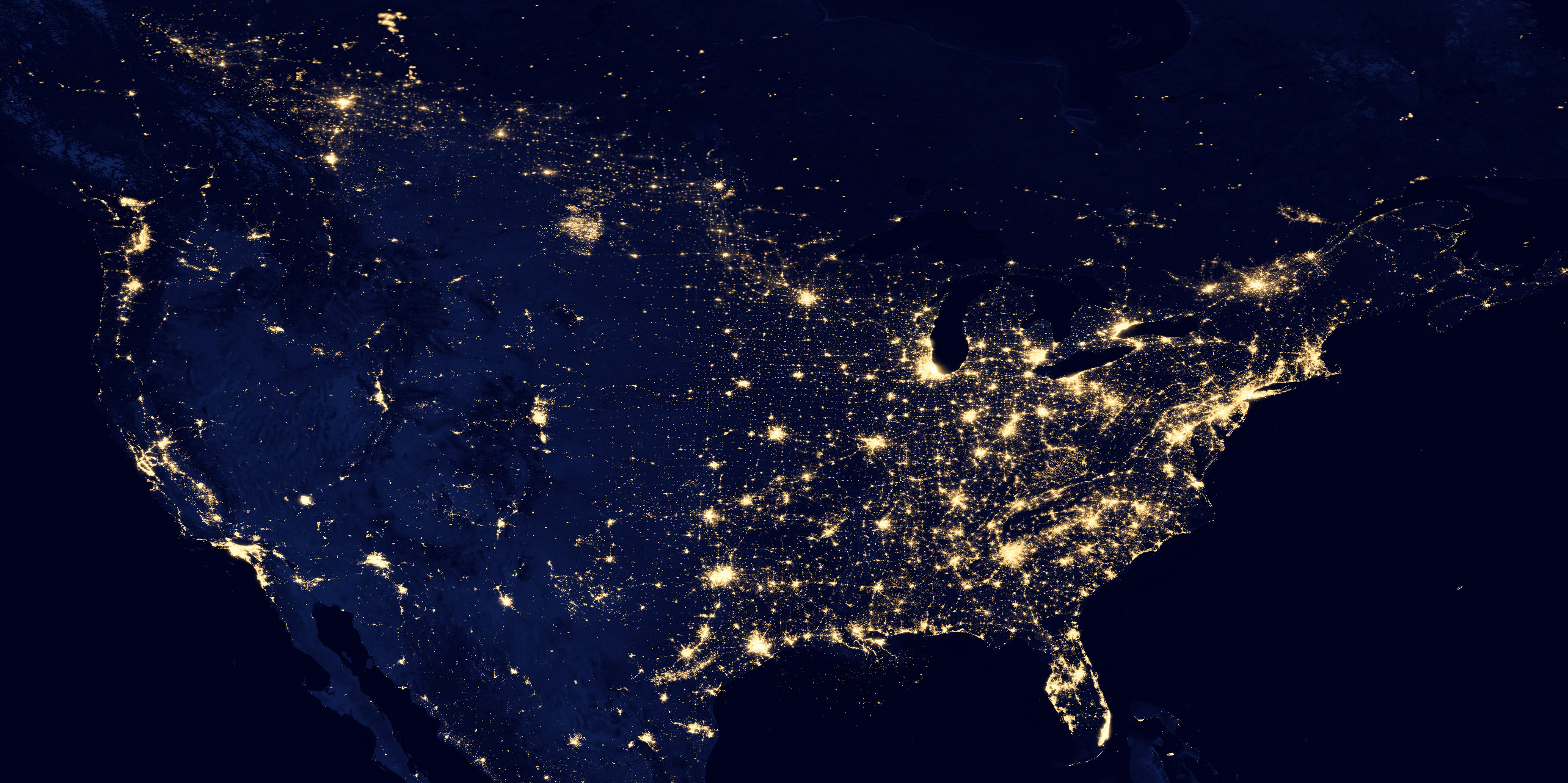
For me, the division between East and West is clearly demonstrated by this night shot of North America.
If you draw a line between Dallas and Winnipeg, the difference between left and right is very distinct. To me, everything left of the line is “The West”.
Where’s Winnipeg in that image? Well, if you can find Chicago you can find Minneapolis and if you can find Minneapolis you can find Winnipeg.
For me, it’s Montana, Wyoming, Colorado, New Mexico and west of that. The one problem is having a “west” that doesn’t contain any of Texas. Maybe you add in the part of Texas that is south of New Mexico.
That’s a fascinating image. I wonder what that large bright spot is north of what I assume is Denver. My powers of geographical estimation are making me think Black Hills of South Dakota, but as much of a tourist trap as that area can be, I can’t imagine it’s that heavily illuminated at night. In fact, it really looks to me a but too far north to be the Black Hills, but I can’t think of anything in western North Dakota, eastern Montana, or southern Saskatchewan that are bigger, and I don’t think it’s far north enough to be Regina or Saskatoon.
In John Gunther’s Inside USA (1946), he opined that “the West” comprised Wyoming, Montana, Colorado, and Utah. Otherwise, you were the Great Plains, the Southwest, or The Pacific Coast. Nevada was disposed of as a satrapy of California, while Idaho belinged either to Washington or Oregon.
If Nevada is not “West” I don’t know what it is (c’mon… desert, guns, gambling, brothels, military outposts, drifters…).
I’d be good with the 100th meridian (but then follow the Nueces in Texas as southern segment) or Bartman’s 20-inch-rainfall line which gets you more bits of OK and the whole Dakotas and lets you touch a bit of Minnesota.