We drove near Kyle SD a month ago; it’s close to the Badlands and Wounded Knee, in the Pine Ridge Indian Reservation. The scenery is like Buzz Aldrin would say, “magnificent desolation”; certainly no beaches in sight…
According to the Kurt Russell movie The Computer Wore Tennis Shoes, the geographic center of the continental US is Lebanon Kansas. And, yes, they do have a monument there.
If you include Alaska and Hawaii, it’s in South Dakota (according to NGS). Geographic center of the United States - Wikipedia
Difference in mass? Are you counting thickness as well? That’s a whole other problem… make a scale model of the country, including vertical thickness above sea level. That would skew the balance point westwards quite some way, I imagine.
(Not sure what you’d do with areas below sea level, eg Death Valley - you might need some anti-gravity material for total accuracy ![]() )
)
You could use vertical thickness above the centre of the Earth instead.
I think some are assuming that the geographic center is on the surface of the earth. Again, it comes down to the definition of geographic center, but if you start considering mass or elevation, you may as well consider the curvature of the earth.
Yes, for most shapes they’ll be different, but for several “nice” shapes they’re the same, including UIAM, any parallelogram in any orientation, an ellipse in any orientation, and a regular N-gon in any orientation provided N is even.
Satisfactory triangles are harder to come by. { (a,0), (0,b), (-a,-b) } works but it has to be oriented just like that.
The above assumes the spherical Earth is actually flat, whereas in the U.S.A. only Kansas is flat. ![]()
Subic Bay is not an American base. Also, American bases in foreign countries are not American territory.
Any isosceles triangle with its axis of symmetry along the line y=x or y=-x will work. In fact, I’m pretty sure that any triangle at all will have some orientation that will work, because every triangle is a projection of an equilateral triangle. It might even be the case that every shape has an orientation which will work, though I’m not certain on that: Certainly, every shape has an orientation where the centroid is on the north-south median, and an orientation where the centroid is on the east-west median, but those aren’t necessarily the same orientation.
I may be confused, but I don’t think this works. Take a very simple isosceles triangle oriented as you describe:
{ (-3, 3), (3, 3), (3, -3) }
The centroid is (1,1), but the common x/y bisection point is (0,0).
:smack: Yes, I was solving a different problem.
Nevermind. :o
And I was right to not be certain on that, as a simple counterexample shows: Take a shape consisting of two almost-equal circles, a large distance apart compared to their radius. For a line through the centroid to bisect such a shape, it must trivially pass through at least one of the circles, which will only be the case for lines a very small angle away from the shape’s axis. Therefore it is impossible for two perpendicular lines through the centroid to both bisect the shape.
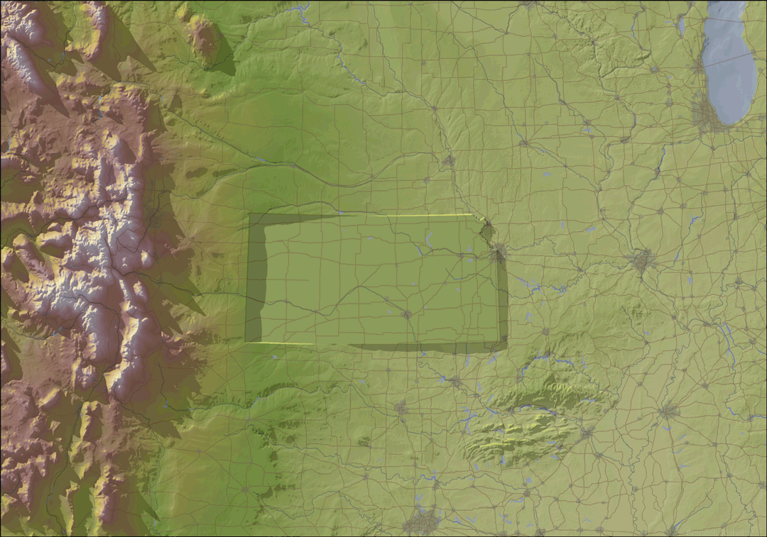
You realize of course that Kansas is a very long way from flat. The highest point, inches from the Colorado border is just shy of four thousand feet elevation while the eastern border is under 800 feet. If you were to plot the land-mass based on elevation, the balance point for the state would be quite a bit farther west than where the level-plain geographic center would be. All of the states in the flyover corridor from ND to TX have this eastward downslope to them.
Yes. See this image: cartographers without borders: Image
The point was that the term “geographic center” is ambiguous and thus to solve the problem one needs to decide on the assumptions before working on the problem to find a result.
Simply that lacking a material truth, one needs choose something to be true to solve it mathematically. I presented a coordinate singularity as an example because it is only an apparent discontinuity which can be resolved by simply declaring those assumptions.
The lack of defined assumptions makes it far more difficult to simplify the problem into a solvable one.
The Center of The Universe, however, is wherever I happen to be at any given time. At least that’s what my dogs tell me. 
This study proved(?) that Kansas is flatter than a pancake. ![]()
You vastly overestimate how much the earth’s surface varies vertically. Since Kansas is 410 miles wide, even a 3200-foot difference only amounts to a slope of 0.15 percent.
Imagine Kansas as a huge sheet cake. The extra weight of that extra-elevation “frosting” to the west becomes almost irrelevant if the cake is even the equivalent of 20 miles deep.
To put this in context. If the earth was the size of a basketball all of the water in all of the oceans, air,aquifers, rivers, lakes and ice caps would fit into a ping ball with no problem.
While the common claim that if the earth was the size of a billiard ball it would meet spec is false (oblate spheroid problem)
Mount McKinley, the most prominent mountain would 26 micrometers or 0.001" tall on a billiard ball.
The Grand canyon would be 8.2 micrometers or 0.0003" deep on a billiard ball.
As the volume of a ping pong ball is about 1.8 ounces what we view as deep oceans would only make that basketball sized earth slightly moist.
This looks a bit smaller than a ping pong ball relative to a basketball.
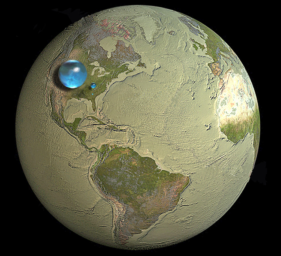
Diameter:
Earth: 7,917.5 miles
All Water: 860 miles
860/7917.5 = 0.10862014524
Basket Ball: 9.23"
Ping Pong Ball: 1.57"
1.57/9.23 = 0.16251354279
I was being conservative.