The Madre Fire became California’s largest blaze so far this year, ripping through grasslands after breaking out Wednesday in southeastern San Luis Obispo County. It swiftly grew to more than 55 square miles (142 square kilometers). There was just 5% containment.
The sky is all blue from here in SLO, but that fire is down wind from us.
There’s a noticeable amount of ash on my car here in Santa Barbara. No smoke smell though. Yet.
I haven’t noticed any ash at all yet.
I was planning to drive to Paso on Saturday. I hope it’s not an issue.
I think the fire is quite east of the 101.
well, it’s not Mt. Saint Helens-style buried, but it’s noticeable.

None at all in my part of the neighborhood. Depends on the wind.
We have a very extensive flood protection system in my area that spans many counties. Some of the land is designated as flood plain land. It’s land designed to take on water when the dams back up. Insurance polices are written to account for that in those areas.
The fire is up to 80,000 acres now with only 10% containment. It’s on the edge of Carrizo Plain National Monument, a favorite spot of mine. I was just there a few months ago to see Painted Rock. Hopefully they can get the blaze under control before it reaches the area.
For anybody not familiar with this area, it really is quite remote and the fuel is mostly ground vegetation that will recover in a year barring a crazy rainy season before next spring. Most people here in the county seat are unaware of the fire.
Gotta love Gov. Newsom’s tweet:
“The #MadreFire — which started on federal land Trump manages — is now the LARGEST wildfire of the year.
Trump hasn’t said a word. His admin is proposing cuts to the Forest Service instead.
Rake your forest, @realDonaldTrump.”
Evacuations have been ordered in central California, as a massive wildfire is churning through the brush-covered hillsides in Los Padres national forest. More than 450 structures are under threat by the Gifford fire, and several injuries have been reported.
The fire had scorched more than 65,000 acres (26,300 hectares) by Monday morning, after the blaze grew out of several smaller fires that erupted Friday along State Route 166 between Santa Maria and Bakersfield.
Gifford keeps growing:
Surprising research:
FWIW, there is a whole lot of nothing in eastern SLO and SB counties. Barely any trees let alone structures. All of the really populated areas are upwind (West) of the fire. I’m curious about the location of the hundreds of structures that are endangered. Hopefully they’ll get this contained before any separate fires erupt closer to the coastal cities.
You are correct, but there is New Cuyama, however I think those ‘structures” would mostly be ranching sheds, etc. Not many homes.
Well, shit! This is the view from my roof in San Luis Obispo.
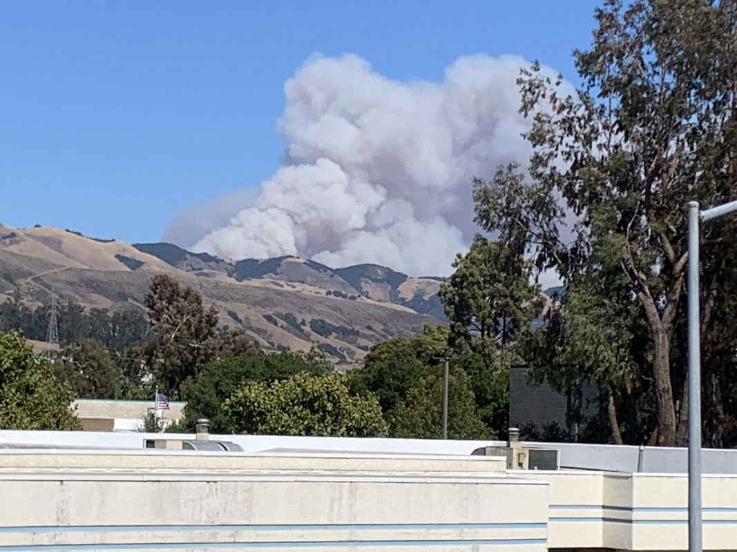
This fire has been spreading northwest against the wind for the last week. I’m not sure what kind of protection, if any, that ridge affords us.
Oh shit. You are in my thoughts.
Wow. I almost even recognize that roof line, but not quite. That is scary! I’ve heard from other friends in the area who are also worried.
Take good care and have that go bag ready! My best to you!
Good news! Just got word that this was set by firefighters. They intend to control burn 50,000 acres.
< Whew > So glad to hear it!