A few years ago, the government of South Korea instituted a new address system, referred to as 도로명주소 (Doromyeongjuso/Road Name Address). The idea was to make it more easy, especially for police, firefighters, and ambulance drivers, to find any particular address. This system replaces the previous system introduced by the Japanese (I think it’s called Gu/Dong System) during the annexation of Korea. Supposedly the Japanese introduced that system because it was more efficient than the previous system in use in Korea.
My question has two parts:
[ol][li]What was the previous system?[/li][li]How inefficient was it? It had to be seriously bad if the Gu/Dong system was an improvement.[/ol][/li]
p.s. By the way, it’s a complete myth that the roads in Korea did not have names. I first lived in South Korea way back in 1977 and all the roads throughout the country had names even then.
Based only on my study of Japanese history as well as its annexation of Taiwan, then it’s possible that there wasn’t a system prior to the Japanese imposed one.
I wouldn’t place much stock an existence of the “supposed” system. Lots of common knowledge about these things are mistaken.
Modern street addressing often was the result of the advent of a modern postal system or for family registration in Japan, for example.
Japan modernized itself after the United States kicked open its doors and the old government was – relatively --peacefully replaced. Prior to that Japan did not have street address. Maps from that era simply had the property owner written on the lot.
Japanese changed the structure of the relationship of the citizens and the government as well, going from a feudal system to a modern one abolishing many of the previous restrictions. The addressing system was all part of that.
When Japan took control of Taiwan it imposed a number of systems such as the family (household) registration, which I believe was also imposed on Korea, but you would know better about that.
One way to test this would be to look for maps prior to the annexation and see if there is any evidence of an addressing system. I can’t help with that.
Arbitrary, adhoc. It was somewhat based on lot numbers. But that is where there a a subdivision.
The wikipedia entry gives the example of a city block.
It says it was like calling a block “world trade centre” and numbering the buildings.
But in a more suburban area, they used lot numbers, or town building numbers.
The difference is that a lot number is the number in a single subdivision, but building numbers may be irrespective of the history of land titles in the area.
So you could have one area where the subdivision lot number did determine the street number, but not as a copy… more of like +55 … add 55 to the lot number … thats your building number.
Its only roughly like using lot numbers.
There would have been areas which did have street numbers on main streets. What happens is that lanes get the main street number it is near , and then buildings along the lane get the lot number… so the lot numbers might proceed in odd fashions around the lanes, just because that area uses the street number and name of one lane-street junction.
Most roads in rural Thailand have no names. I confirmed that for “our” road which connects a dozen villages on the road (and a dozen more near the road) and is also a major route for longer journeys unrelated to any of those villages — for a few days I asked everyone I saw what the road’s name was and was answered “We don’t talk like that around here. We just say we’re going to Village Such-and-So.”
So addresses just have the form “176 M. 5 Sname Dname Pname”, house number, village number, names of subdistrict, district and province. We built a new house and were assigned the number “95/1” because we were adjacent to house “95”; but I told them I didn’t like the “/”. No problem: they gave us number “176” instead.
Several years ago, a decree went out that house numbers had to be visible, but for houses like ours not on the main road, the postman won’t find the number unless he already knows how to find the house. I’ve never ever heard anyone refer to a house number here. (Though certain application documents must be accompanied with a photo which shows relevant family members, house, and sign with house number all in the same frame.)
Although the most important part of the address, “176 M. 5”, requires little English skill to read, a postcard so addressed in English to a foreigner was delivered to a different foreigner several villages away! If not for that I’d never have met that interesting guy, some of whose escapades I’ve related here at SDMB.
From the two years I spend living in Osaka I would say Japan’s addressing system is still a mess. It’s not based on street names and numbers but on subblocks which are numbered and then the building is numbered. But if you don’t have a map of the local sub-blocks there is no logical way of knowing which side street to go to from the nearest intersection. Finding a building without using google maps was tedious and time consuming even if you had the full address. Most times even the local taxi drivers couldn’t find an address without me showing them on google maps.
Which wiki entry? Can you verify that you are not discussing the system implemented by the Japanese, because it sounds like it could be.
Now I’m back at home, I can search for maps.
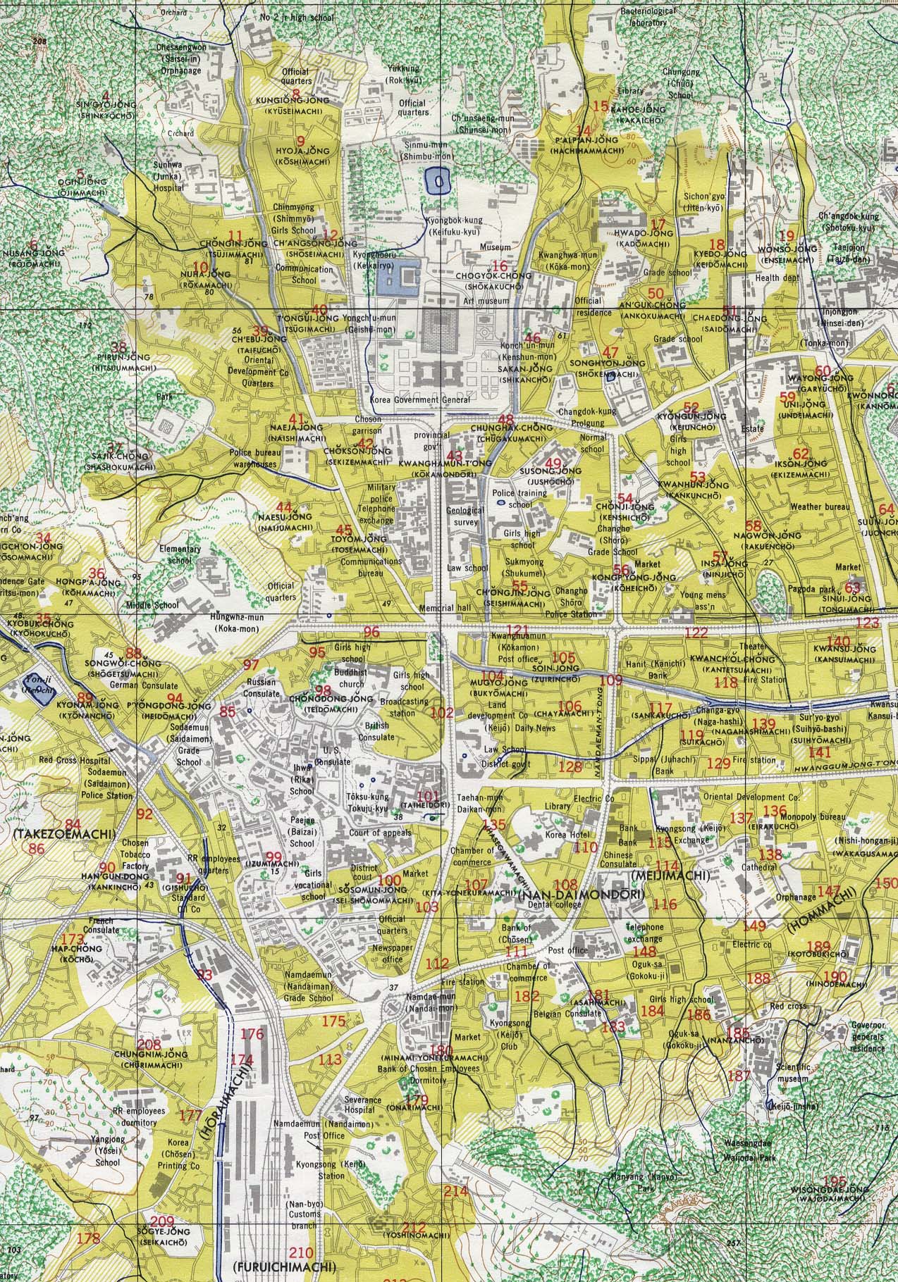
Compare this map of Seoul circa 1910 to this one of 1945. There isn’t an addressing system imposed on the the former one but there is one on the latter. This doesn’t mean that there wasn’t a system existing in 1910, but there isn’t any evidence from this map.
QFT. Yup, imagine up poor people who were there prior to google maps.
When I was driving around on a motorcycle in the mid 80s, I would make copies of a map, put them in a clear pocket and would occasionally stop to update where I was
My point was that there was no addressing system prior to the one created in the Meiji Era.
I think you’re unconsciously referencing the US system, where the first figures in a house number refer to the intersection. That one can take quite a while for people used to “all lots on a street, road or equivalent are numbered sequentially”, mainly because you guys find it so obvious nobody thinks of explaining it. So we’re there scratching our heads and wondering why do numbers jump so much, until a kind soul finally explains…
What’s an obvious and logical system to those used to it can be completely confusing to someone encountering it for the first time, and vice versa
The 1910 one looks very similar to pre-Meiji era Japanese maps. That would be an interesting period to study. (Knowing of course that the Japanese started to really exploit Korea later on.)
