Isogonic lines (lines of constant magnetic declination), including the special case of agonic lines (lines of zero magnetic declination) don’t follow great circles, and the agonic line doesn’t represent a great circle through the magnetic north pole.
This 2015 map from Wikimedia shows the agonic line in 2015 looping over the poles and through equatorial Africa. D_merc (wikimedia.org)
There’s been some discussion of the Irish grid and whether this phenomenon has also occurred in Ireland. As brossa correctly says, the agonic line has moved over Britain from the east and we still have a negative (westward from true north) deviation in Ireland.
I’m going to suggest a candidate: One or more zones of the India Grid. The Wikipedia map from 2015 showed the agonic line running approximately east-west across the territory of India, so it seems very likely to intersect the longitudes of origin of some of the grid zones (68E, 74E, 80E, etc.)
And scroll about half way down you will see a map of the world with declination ( difference between magnetic field and true north) . If you are on the green line anywhere in the world you have currently zero declination, so magnetic north and true north line up.
If you want to find somewhere where grid north , true north and magnetic north line up then that line will have be across what ever location as chosen for that countries grid north.
If you look at India you can see the green line goes across the country at a 45 degree angle, and if Indias grid meridian line is a straight north south line , there is only a point where the green line of zero declination and the grid meridian will coincide
I know magnetic north wanders over time. But I’m confused about something else in this thread:
People are talking about how suddenly there is a new alignment of Grid North and True North. I don’t understand this.
True north is permanent. And Grid North is also permanent. It is set by every country (or in the USA, every state) as a convenient local definition of North. And once it is defined, Grid North it stays permanently.
The grid is defined to make mathematical calculations easier than using spherical geometry., and those calculations don’t change…
So what is so unusual about the convergence of three Norths–it seems to me that only one North (Magnetic) is changing position.
What am I not understanding here?
No, GN and TN haven’t changed, it’s only magnetic north that is changing. The grid in Great Britain is aligned with the meridian that is 2 degrees west of Greenwich. It is interesting to map users in Great Britain that compasses will happen to point due north somewhere on that line for the next few years. That’s all.
Grid North is permanent, and so is True North, sort of.
The point where the Earth’s rotational axis penetrates the surface does wander a bit. The movement is called the Chandler Wobble, and has a period of 400 some days. The path it takes isn’t very big, but I suppose if we were being super super pedantic then True North would wiggle back and forth a tiny amount from week to week while Grid North remained fixed at some average value. So the ‘three norths’ would only be in alignment when Grid and True North were really aligned. Apparently the GPS network has to account for the effect. Although - maybe the wobble would just make True North align with one of the Grid North lines to the east or west of the 2º west line! That way the agonal line sweeps from east to west, the ZMGA line sweeps from west to east, and the Grid North/True North agreement line oscillates back and forth east to west. That way the ‘triple north’ point can describe sort of a sinusoidal path northward across Great Britain instead of just following a line.
It turns out that here in the States, the UTM grid is aligned to True North along the center line of each grid zone, so that’s along the 75, 81, 87, 93, and 99 W latitude lines. We’re too wide to have a single grid alignment line. And the agonic is currently running very nearly parallel to the 93W line, but appears to be crossing it in northern Iowa at the moment, and the crossing point will sweep southward through Iowa through 2023.
It’s probably also happening in Argentina at 69ºW right now, but I’m not sure of their mapping scheme, so maybe not.
Yes agree
The UK article was specifically talking about an event in the UK and not claiming this was a unique only happening the UK historic event .
The US has a national grid now aligned with the UTM system and also building in connections to GPS systems and less state controlled grid systems . This will hugely assist interstate and federal disaster assistance when resources are moving from state to state and having a common reference system .
The civilian part of the US mapping & disaster management bureaucracies have jointly decided to begin using the geo-referencing system the US military has been using since the 1950s.
And they’re now encouraging state & local governments, GPS navigator manufacturers, and various private actors to use the same system as well.
The punchline being: this isn’t a new system. What’s new is breaking down the silo where the civilians refused to acknowledge or use the military system that was free, unclassified, and readily available all along.
MGRS is just the UTM system plus universal polar stereographic for use over the poles. It works well for a lot of things where you need a notional regular rectilinear grid. But it isn’t accurate enough to do measurements on the ground when you are, for instance, surveying land allotments. It has a built in scale error. Nothing that causes grief if you are communicating a location, or marching up and down. But not good if you expect lengths and areas to be comeasurate. That tends to need a datum a lot closer to where you are than the nearest 500km.
It has quite a few other really weird issues with literal edge cases. When you get a location just over the edge of one MGRS/UTM tile it is allowed to be listed with the coordinates relative to any or all the tiles it may sit in. So a location may have up to four MGRS coordinates depending one use.
Lat Long is more universal, but a pain to navigate in. Nothing is straight or straightforward. MGRS/UTM lets you navigate as if the Earth is flat. But only for so far.
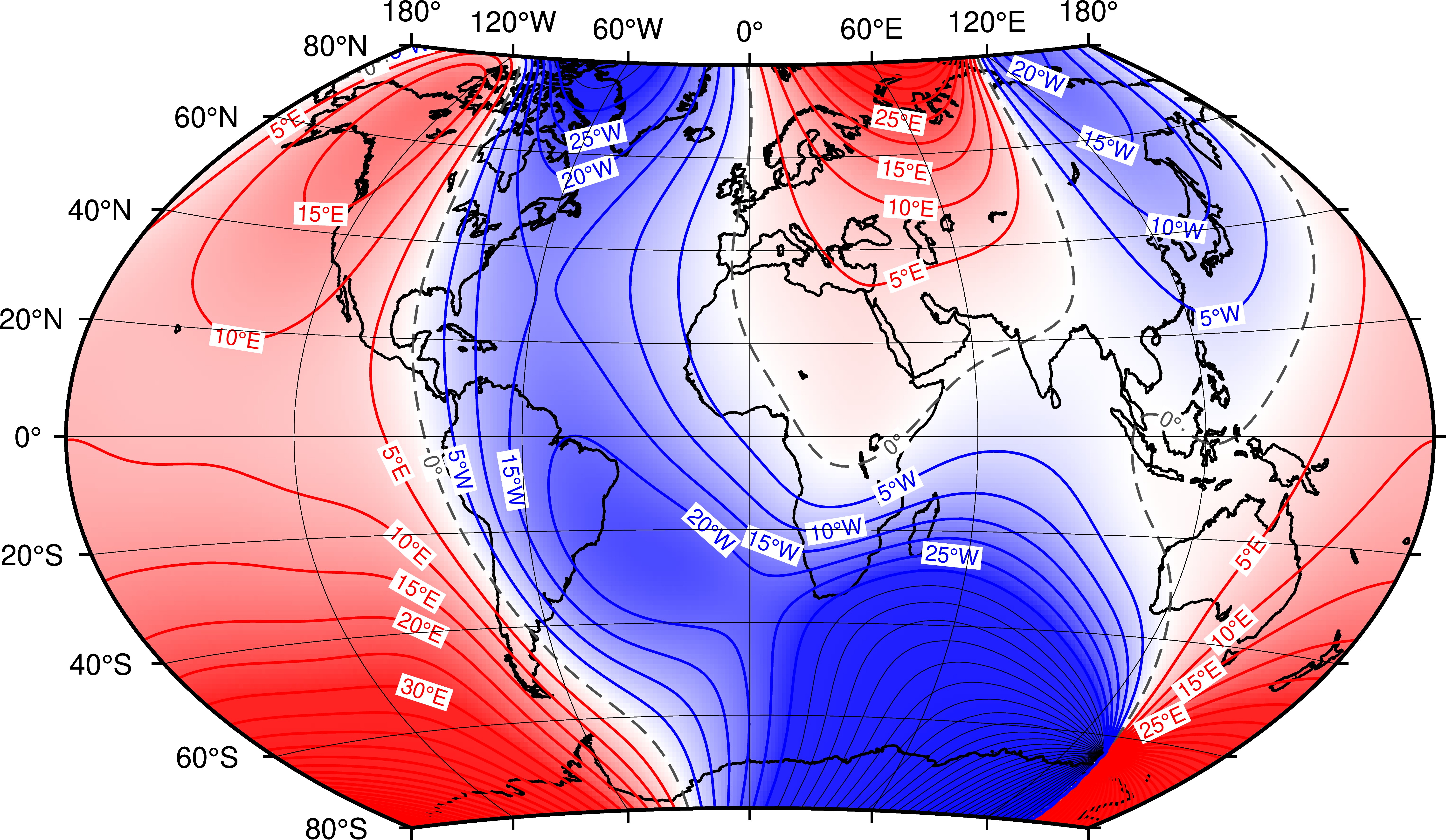
It’s been linked to above, but here’s the map inline:
Anywhere on the green line(s), magnetic and true north are in alignment. And I’d suppose that just about anywhere on Earth has some local notion of “grid north” for their city/state/country/whatever. Which means there are probably dozens or hundreds of locales where true/grid/magnetic north are aligned at any given moment.
What’s fun about all this (to me at least) is how fixed, organized, and regular the human-made notion of latitude & longitude are versus the messy reality of how the magnetic field is sorta kinda organized except all the places it gets wacky while it’s constantly in (slow) motion.
It’s a parable about how humanities’ notions of regularity are impressed upon a messier underlying reality in just about everything.