Seems to me (at any rate) that by traditional definitions, if one were to BE AT the north pole, there ceases to be any direction from where you are that is north of you, and also that there is no east or west from there; instead, every direction you could proceed in is by definition due south.
Also seems to me that navigational equipment would not appreciate that and would be totally unable to plot a course to anywhere or to make distance estimates, etc.
Is this an issue that simply never comes up due to the lack of common reasons for navigational equipment to end up right smack dab at one of the poles? Or is there a convention by which orientation and direction can be established in such a situation?
Hmm, flying OVER the north pole seems like it could be a headache also. North is under you. So is south. Oops.
I wondered about this too and I looked into it a while back. I can only vaguely remember but I think they plot positions based on meridians - imagine that, looking down on the north pole you take the 0º/180º meridian as the “north/south” (or “up/down”) axis, whatever you want to call it, and the 90º/270º meridian as “east/west”/“left/right”.
Bear in mind, of course, that compasses point to the magnetic north pole which is hundreds of miles from the geographic pole.
I started explaining geometrical alignments and decided it against it. The answer is you can only go south. For our Earth coordinate system up and down is altitude and doesn’t affect your west, east, north or south direction of travel. Study polar coordinates if you need to learn why.
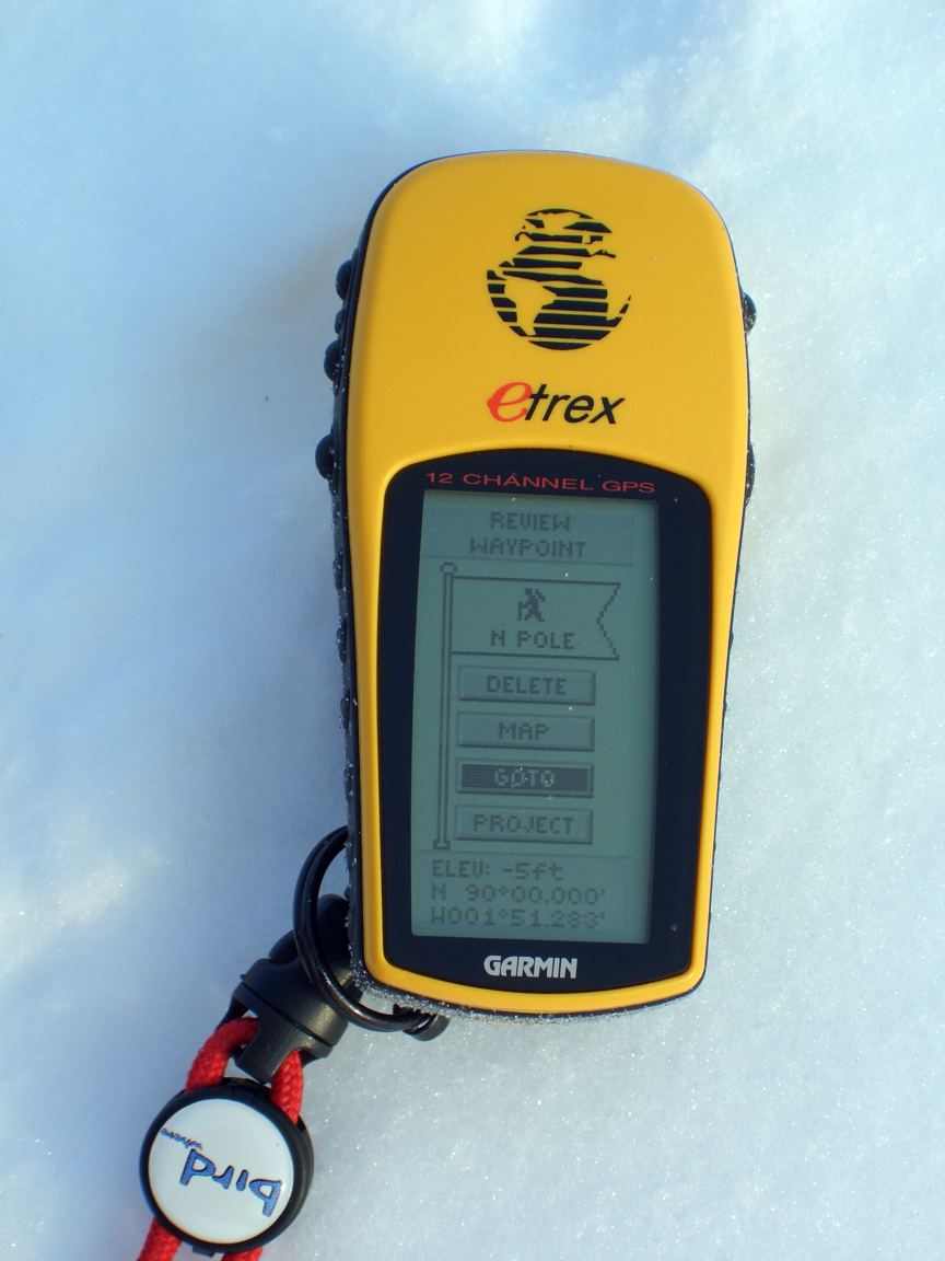
Yes, grid navigation is used in the polar region. The grid north/south line is aligned with the prime meridian, and everything else is derived off of that. The magnetic compass is useless in that region. I found this article that gives more details on the procedure.
From any frame of reference other than the pole, West Antarctica is, by and large, west of East Antarctica. Do a Mercator-style map (parallels and meridian-like lines through any given point are rectilinear to each other) of, e.g., Australia and Antarctica, and W.Ant. will be in the same direction from E.Ant. as Perth is from Sydney.
===============
Not quite accurate but close enough to justify the generalization – to reach the North Pole from Canada’s northernmost military base (and settlement) at Alert, Nunavut, you fly magnetic due east on takeoff*, because the North Magnetic Pole is marginally south of geographic due west of Alert, so it’s a reasonable approximation of the truth to say that in Alert, compasses point west.
The appropriate compass course will vary over a ~90 degree range if one heads in a straight-line course to the Pole, as one’s position relative to the Geographic and Magnetic Poles changes.
I’ve actually been to the North Pole in a submarine back in the early 1990s.
The OP is absolutely correct. When you get very close to the North Pole, it screws up the navigation equipment. We used gyrocompasses, which attempt to point to the north celestial pole (approximately toward the North Star). When you get very close to the pole, they really get screwed up because they can’t keep up with the changing direction of north. A screwed up gyrocompass results in screwed up gyrocompass repeaters on the Ship’s Control Panel, and the helmsman is then unable to steer a straight course.
We addressed the problem by temporarily redefining (for our navigation equipment) the location of the North Pole as being on the equator at its intersection with the prime meridian (0° Lat - 0° Lon). The gyrocompasses were then set to point to this new “pole.” This created the interesting effect on our fire control computer as showing our sub’s track in the Arctic Ocean as appearing to be occurring in Africa. (Our Navigation Officer and the quartermasters knew where we really were on our charts, of course.) The GPS system was also unaffected, though we had some minor difficulties in picking up a sufficient number of satellites at times, because some of them were low on the horizon.
Why not just recalibrate to look for magnetic North instead? Or have a whats-it with a compass in it that’ll say where you are vs how far from the magnetic pole you are?
Because we sailed in close proximity (relatively speaking) to the North Magnetic Pole as well, so it would create the same problem for the gyrocompasses. You need to have the gyros pointing at something a long distance away.
Also, the North Magnetic Pole is not a static point. It drifts by something like 10-30 miles per year. It has varied by several hundred miles over the last century. It’s currently somewhere west of Greenland. As we sailed toward the north pole, the north magnetic pole was north of us, then due west of us, then south of us.
Magnetic north is really only useful for magnetic compasses, and then only if you know the appropriate magnetic declination. In modern navigation, it’s only used as a rough check on the more precise navigation systems. Even then, a magnetic compass doesn’t work well because of all the metal and electrical equipment on board. Magnetic compasses also get wonky in close proximity to the magnetic poles, because the Earth’s magnetic field is not a true dipole.
I think I disagree. Western Antarctica is the smaller portion between the Ross Sea and the Weddell Sea, right? From a point in Eastern Antarctica on the same longitude as Sydney, Western Antarctica can be reached by going either west or east, but it’s much closer if you go east.
I suspect that the names were assigned because they generally follow the conventions of the western and eastern hemispheres.
I can’t believe no one has mentioned this yet. Wikipedia is your friend.
West Antarctica: “West Antarctica, or Lesser Antarctica, one of the two major regions of Antarctica, is the part of the continent that lies within the Western Hemisphere including the Antarctic Peninsula.”
East Antarctica: “All but a small portion of this region lies within the Eastern Hemisphere, a fact that has suggested the name.”
Years ago I read an article about early Antarctic exploring. I don’t think this story was told as a joke, but it could be one: It’s lunchtime for an expedition, and one member who’s Catholic realizes it’s Friday and he can’t eat the beef dish the rest of the expedition is about to have. One of his buddies says, “Walk 20 feet that way, over the International Date Line, and it’s Saturday there.”
This caused me to wonder – how do submarines get a GPS fix? The signals won’t penetrate the water the sub is under, will they? Does it only work when you surface, or do they have floating antennas that are released to get a fix, then reeled back in so the sub can move … or what?
GPS signals are in the UHF band, which do not penetrate seawater very readily. Subs can get a GPS fix from an antenna in one of the periscopes when they are at periscope depth.