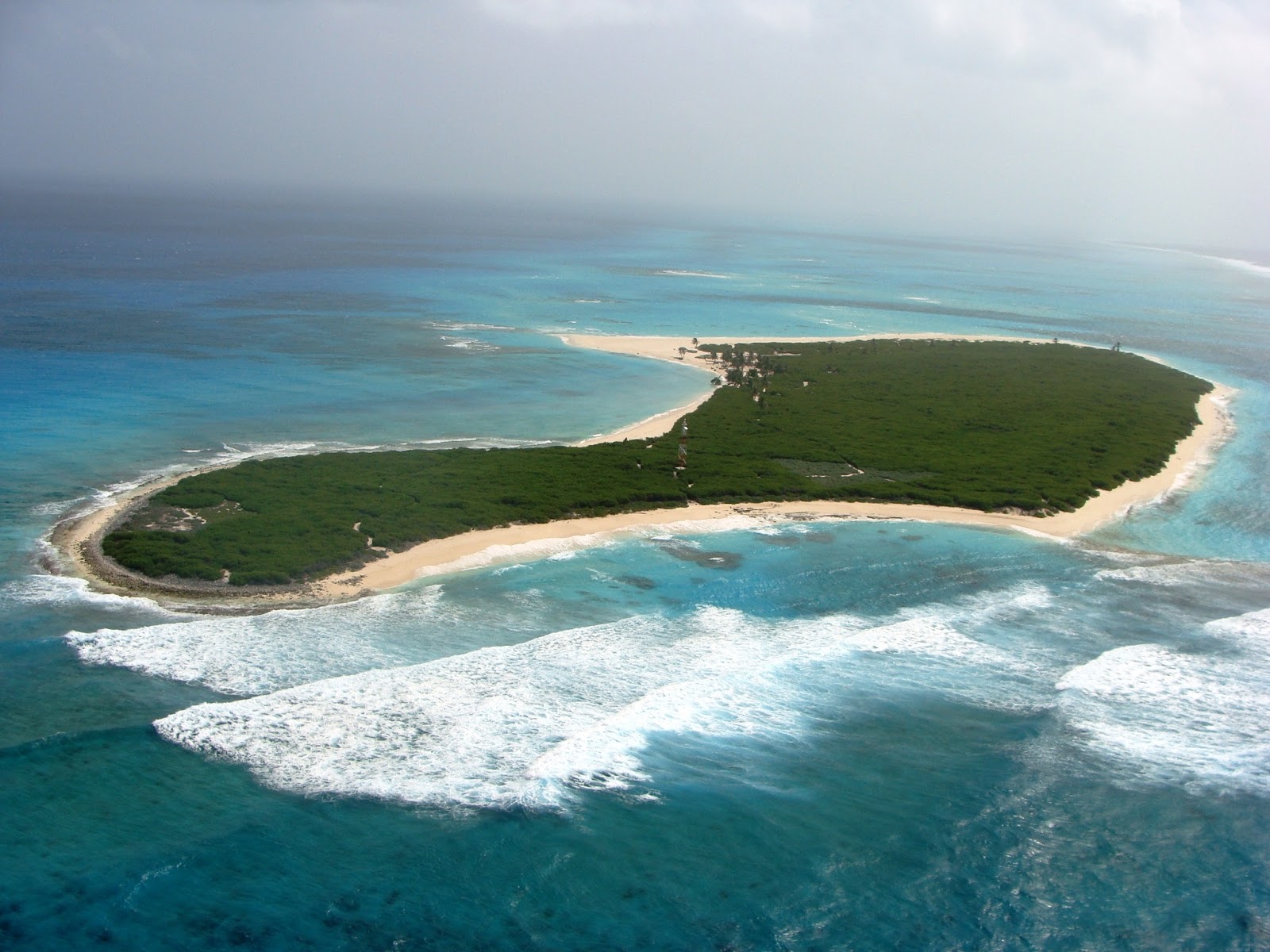
It’s about 150 miles east of Nicaragua, in the Caribbean. Google maps shows nothing there; change to satellite view and it’s a large reef with a few scattered islands, just dots really. But at the coordinates there’s a larger island, unidentified, with a few trails running across it, and a man-made circle of something near the beach.
That is Southwest Cay, a part of the Serrana Bank. It is Colombian territory.
ETA: As the Wiki link notes, it was claimed by the United States until 1981 when the States relinquished its claim. There used to be a US military base but likely not much left there since Hurricane Felix passed over as a Cat 5 in 2007.
I have a 1980s Britannica Atlas that says the island and associated atoll is collectively “Serrana Bank”. Even farther to the NE is a lesser gathering of islets labeled “Serranilla Bank”. That same map shows a number of other minor atolls and islands within a couple hundred miles.
those aren’t trails, they are roads, wide enough for two vehicles to pass.
there’s a communications tower at the narrowest part of the neck at the South West.
there are two very odd camouflaged triangle-shaped clearings at 14.286907, -80.364106
at 14.286051, -80.363813 there is what looks like an old landing strip being slowly overgrown.
There are quite a few buildings scattered about, some haven’t been driven to in years, but the approaching roads have been maintained. Given the locale, I wouldn’t say any of it has been overgrown since 2007 though. We’d need different technology to see much of anything after ten years.
Looks like there might be a vehicle at the house. And how about the two “C” shaped items on the beach near the house? If you look closely at the fog covered area, there seems to be a 30 foot high wooden wall cutting off the end of the island…
Modern Goldfingers don’t like it when you publicize their secret private lair. Ref mixdenny, who’s to say that cloud cover on the northeast end is natural?
Good thing you too have a heavily defended citadel to retreat to. Shame about your family though.
NO ROADS. They are just sand trails. The sand spreads out and makes it seem wider, the vegetation comes and goes with the sand… but definitely no one ever put down a sealed road, or even a crushed rock road there. No permanantly situated vehicles drive those trails. ( Maybe someone had a jeep or motorbike… who is to say it didn’t happen. But there’s nothing there to indicate even a garage)
The loss during Hurricane Felix was the thatched shelter where tourist group would get out of the sun
Good find Isilder. Note the comments at the bottom. The most recent post is only ~35 days ago by someone who visited the island last year as a part of a biosciences expedition.
No mention of secret volcano lairs, nor unexpected space launch facilities. Damn.
I’ve been to San Andres and Providencia, too–during Semana Santa once when I lived in Colombia. (It’s a common vacation spot for Colombians.) I knew there were some other islands in the department, but could never figure out if people lived there.
San Andres and Providencia are interesting, because Pilgrims went there, too–not just to New England. (Hence the name “Providencia.”) Because the colonies there were administered so differently, however, the pilgrim colonies on these islands didn’t last so long.