The OP will find Continent - Wikipedia informative. Which will support the posters above that there are many competing soft-ish definitions and fuzzy-ish divisions.
There is no ambiguity at all. There are six continents. North America (5), South America (2), Africa (3), Europe (5), Asia (7), and Australia (2). To hold to any other listing would be a risky proposition at best.
There’s Antarctica and Zealandia …
India has a better claim to being a continent than Europe does.
Actually, if you look at the maps, the Kamchatka area is part of North America. And Iceland is fifty-fifty between North America and Europe. Very important that North America holds on to Kamchatka and Iceland.
Hmm. 5 + 2 + 3 + 5 + 7 + 2 = 24. Sounds as good as any other number proposed so far.
Or perhaps I misunderstood your parenthetical numbers? ![]()
I am confused to by what he means.
There are by geologic name (not politically sectioned region) the following plates supporting major landmass, as of current history, and with full understanding that nature can change the facts at will.
N America
S America
Eurasia
India
Australia
Antarctica
This does not count the oceanic plates
It also does not add Zealandia yet, someone more educated than i can make that call.
Nature can at will fracture a plate, and then you get two and some highly educated person has to decide if it is a continent or not.
That person would not be me, id simply say is it more than just a spec? is it non volcanic and moves on its own, on its own base rock?, ok its a continent.
Dont take the continental names to heart, the names are political and semi meaningless.
For example N america extends past greenland and extends to NE Asia in a big way
and consists of an asinine amount of salt water
Australia butts up against India and was thought to be fused, but it isnt, yet politcally australia would appear to be an ocean away from india.
Zealandia is a little piece of australia that appears to have broken off and mostly sunk
So based on above water land mass, is it continent plate or oceanic plate with big island?
Here is kind of a cool picture World Plates
This is what i think when you say continent, i dont think of countries per say
Surely Africa should be on that list. And, if the Indian plate counts, then the Arabian plate seems like it could, too.
You can not hold onto Iceland.
It is like hawaii, its a volcanic vent hotspot leak mother earths ghost pepper burrito fart what ever.
It could vanish into the ocean at some point depending on what the plates do, or it could begin making an island chain or something.
Can not really choose to hold onto it though. it will do what ever it does.
Holding onto it is political, we are talking geological.
And i would hope to hell that human beings either get over their stupidity or become extinct before continental drift creates any political issues.
OMFG i forgot africa, i thought i typed africa :smack:
Arabian plate counts but not for continental land, it’s mostly water
(so sayeth the experts)
This is painful to watch, so I’ll point out that the numbers in parenthesis are their respective values in the Risk boardgame, which is also where the references to holding on to Iceland are coming from.
These are the minor plates.
Supposedly because they do not consist of a large amount of exposed land area.
I find it funny that one geology site relegates the arabian plate to minor because of its ratio of land to water.
To me it’s just small, i dont see much water, but then i am not trained to look at these things.
Somali Plate – 16,700,000 km2
Nazca Plate – 15,600,000 km2
Philippine Sea Plate – 5,500,000 km2
Arabian Plate – 5,000,000 km2
Caribbean Plate – 3,300,000 km2
Cocos Plate – 2,900,000 km2
Caroline Plate – 1,700,000 km2
Scotia Plate – 1,600,000 km2
Burma Plate – 1,100,000 km2
New Hebrides Plate – 1,100,000 km2
The funny thing is it is all relative.
Nature can at will drop a major continental plate to the bottom of the sea, and now it is an Oceanic plate, and it can shove an Ocean plate up into the air, and now it is a continent.
It can fuse several minor plates and now they are a major plate, and it can snap eurasia in half and now it really is europe and asia with the new inner eurasia seaway.
Nature also likes to shuffle these things around the world for a bit, then mash them all together again into one giant super continent, then break them apart and start over again.
There are lots of little micro plates too, but they are usually just grouped with the major plate they are following around.
Are you glad mother earth didnt design your house?
Now i feel left out
I’ve never played risk.
I remember wanting it as a kid, never happened.
But ok now i understand i think ![]()
I will pretend i understand ![]()
Kind of interesting to watch
240 million years past to 240 million years future
Would make for interesting politics, hopefully by then there wont be any
I didn’t know Madagascar was part of India!
Very true - Suez is a sea-level canal.
They don’t actually go over hills. They do go up to Gatun Lake - a dammed-up lake 85 ft above sea level, that covers about 40% of the length of the canal passage and supplies the water needed to operate the locks.
All hills that even threatened to get in the way were removed when the canal was built.
I think Colibri’s answer will have to do with the fact that North America consists of not a single plate, but several that have rafted together. See the book Assembling California by John McPhee.
To be fair, most of North America is one plate.
No house rules.
You really shouldn’t be proposing that the continents are made up of single tectonic plates or geologic structures if you lack the basic information about them.
Simply looking at a map of tectonic plates will show that although most of North America is on theNorth American Plate, it also incorporates parts of the Pacific Plate (Southern California and Baja California), the Caribbean Plate (Honduras and Nicaragua), and the Panama Plate (Costa Rica and Panama). The North American Plate also incorporates eastern Siberia in Asia, as well as Greenland and most of Cuba.
The North American Plate simply does not coincide with the continent of North America. The continent includes parts of at least four separate tectonic plates, and the North American Plate includes part of Asia.
Even much of the North American Plate is composed of accreted exotic terranes that smashed up against western North America and are not part of the core continent.
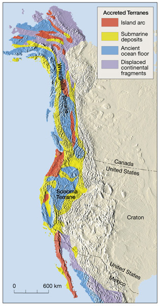