I’m curious, as this strikes me as a more accurate (or maybe just different) way to determine a country’s true size than its mere land mass. Canada, for example, is famously huge…but the majority of its population hugs its southern border, and there are enormous stretches that for all intents and purposes are empty and un-visitable. Ditto Russia, and Alaska.
So what country is the largest in terms of inhabited square kilometers? What US state? Is there a ranking somewhere?
My WAG is that India is #1, followed by the US, China, and Brazil. For US states, I’d guess California is #1, then Texas, and Florida.
How do you define “inhabited area”? If someone owns and lives on 50,000 acres in the middle of nowhere, does it all count as “inhabited area”?
If not, you need to define some arbitrary rules to define it, and then get all the countries of the world to use exactly the same arbitrary rules to calculate their area.
This doesn’t work unless there is a real need for it. UN agencies have standards for some types of statistics - like agricultural or pasture areas - but not for essentially useless stats like this.
What we have is population and area, and the derived population density, but not much else. Maybe you could use agricultural area as some kind of indicator, but I’m not sure how interesting the stats would be.
Population density isn’t quite what I mean. For example, New York state might have a high average population density, but it’s not evenly spread out over the whole state.
For the purposes of my question, if someone owns 50 square km and lives on one of them (and no one else lives on another square km of the land), then it counts as only one square km of inhabited area.
As for “usefulness”, I’m not claiming any - it’s just something that interests me. Why? Because in my mind it would give some vague kind of approximation of the human scale and diversity of a place. I.e., a country with more people in more places and more regions is “bigger”, and maybe more interesting to visit. That’s all.
What about a region of one square km, where only one person lives, but in a small house? Does the whole square km count as inhabited? I am just guessing that there might be maps that give you inhabitation by square km, and from those maps you might be able to extract what you want, but only if you don’t count the above sort of situation as a problem.
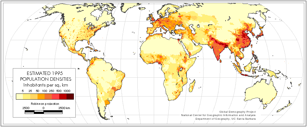
Obviously it depends where you draw the line between inhabited and uninhabited, but if we take a typical world population density map like this one http://www.china-mike.com/wp-content/uploads/2011/01/world-Population-densities.gif , and ignore the palest-coloured areas, it seems to be a toss-up between India and China. Large countries with spread-out populations. The USA doesn’t seem to have quite enough people to be in the running.
Edit - on second thoughts, quite a lot of USA and Russia is in the pale yellow category on that map, so maybe they are contenders.
I guess it’s not easy to come up with a hard definition, but I believe I understand where the OP is going to:
We are looking for a large country, both in terms of area and population, where the population is more or less evenly distributed over the whole country.
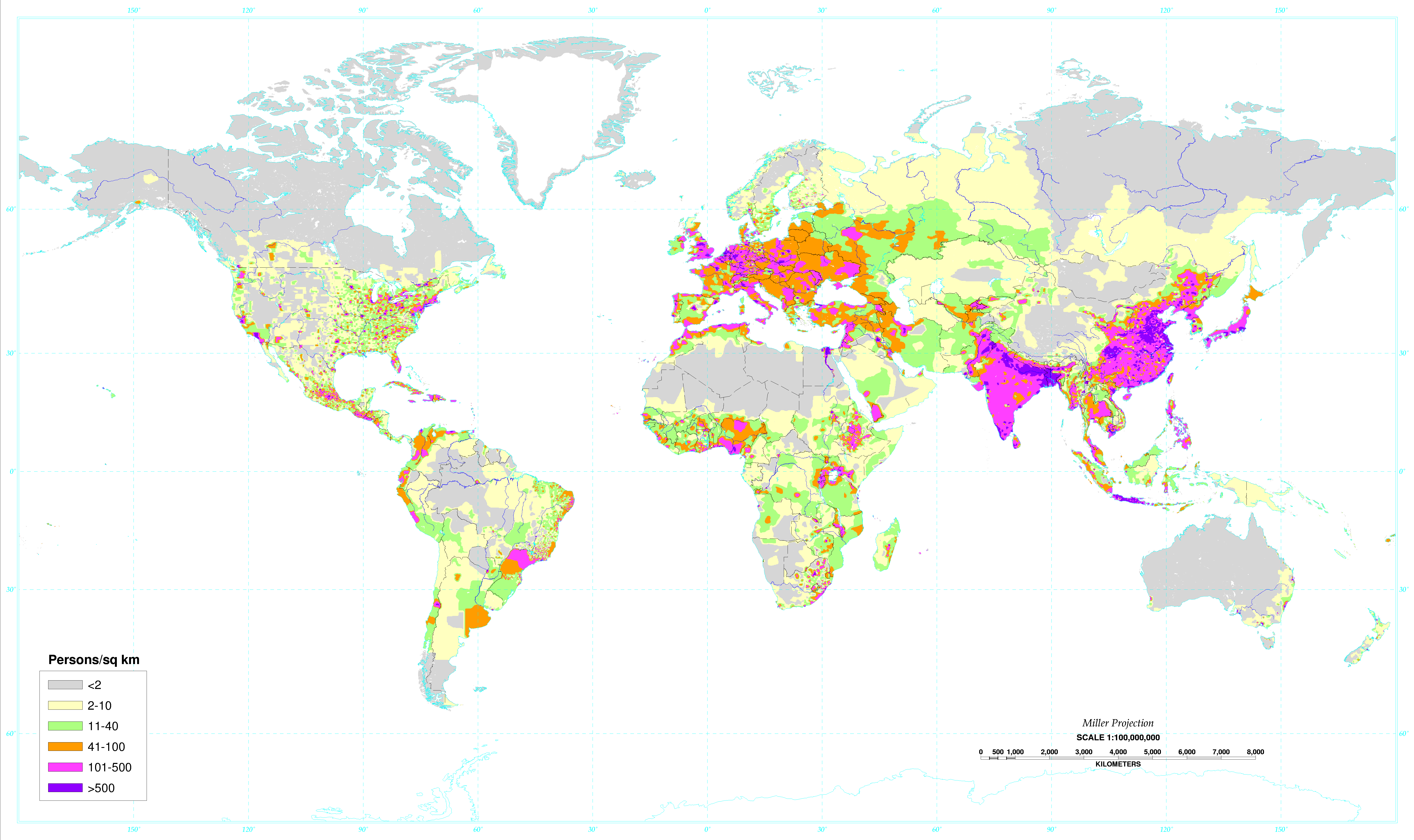
Here’s a population density map which works on an area rather than country basis. Bear in mind though, it’s not an equal area projection map, land in the northern hemisphere is exaggerated in size.
China would certainly be ahead of India even though it contains most of the Himalayan plateau, as it is three times the size. Looking at the map above, I’m pretty sure the top 3 would be Russia, USA and China, but I’m not sure in what order.
Okay, this isn’t exactly what I was looking for in the OP, but it’s somewhat close and may be easier to find out: what countries have the largest number of named “places” - meaning cities, towns, villages, hamlets, burgs, etc., from the biggest megalopolises to the smallest one-stoplight towns?
Yes, that would miss the scattered areas where one person lives in isolation, and wouldn’t measure the sprawl of big populated areas. But it might give a sense of the spread of humanity that I’m looking for.
Note that I’m not looking for absolute population numbers. So by this ranking, a country that had exactly one “place”, a city of one million people, would be “smaller” than a country that had one hundred towns with a thousand inhabitants each.
I would still bet on the US. Except for in Alaska and a few federally-protected wilderness areas, the US doesn’t really have vast swaths of completely uninhabited and undeveloped land that other large countries have. Even in seemingly empty places like northern Nevada or parts of the western plains states, there’s still roads and rudimentary infrastructure and there’s still people living out there by themselves in the middle of nowhere. In contrast, in places like the Gobi Desert or the Canadian and Russian arctic or the Amazon, there’s a few settlements but nobody really lives at any great distance from them. Rural America has very low population density to be sure, but I’m thinking for the purposes of this exercise even if only one or two out of every ten square kilometers has someone living on it, that’s a significant difference versus zero inhabited kilometers out of thousands and thousands.
Here’s a list of the largest countries by square km of land area:
Russia 16,377,742
Canada 9,093,507
China 9,612,945
United States 9,161,966
Brazil 8,459,417
Australia 7,682,300
India 2,973,193
As you can see, India is half as large as Australia, and other countries are even smaller.
But, all these large countries have large areas that have very low population densities. We can exclude Canada, Brazil and Australia right off.
That leaves Russia, China or the United States as your candidates. Russia is a lot larger, but it has half the population of the United States, and vast areas of taiga that are very sparsely populated. China has the Himilayan plateau and the Gobi desert, the United States has the Rockies, Alaska, and the western deserts.
I would guess that the winner is probably China, looking at population density maps and excluding the lowest density areas.
To sort of expand on my point, here’s a google earth picture of what I think is just about the most desolate swath of the continental US you can find: Google Maps
And here’s a picture of the Gobi Desert at about the same scale factor: Google Maps
When you’re down in it, the Great Basin sure seems empty, but China has several HUGE regions that are desolate on a whole different magnitude than anything you see in the continental US. Even zoomed out, you can see all sorts of signs of human habitation in the Great Basin, with lots of small towns and small agricultural regions, and if you zoom in and really start exploring, you’ll find plenty of small ranches and farms or mines or even just mysterious houses or trailers where people are living out in the boonies doing who knows what for a living. Compare that to one of the Chinese desert regions, where you can practically count the structures on one hand.
Have a look at some of the maps here and see if they answer the question, or here’s an interactive map you might prefer. If you spot some kind of data source, I can map it against land area.