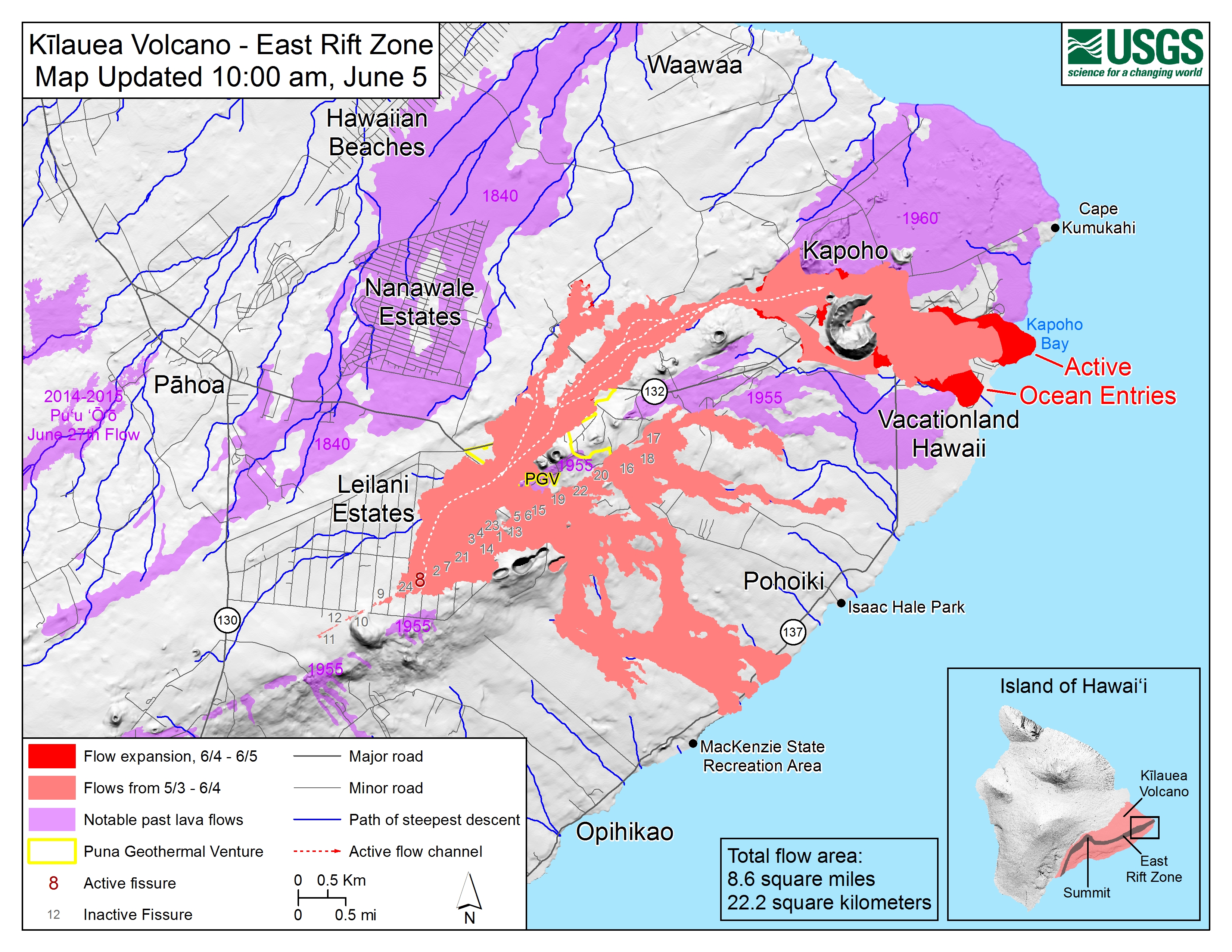
I’d like to see current maps of the lava flow from the Kilauea eruption (preferably satellite image, but a regular map will do). I’m very curious as to how close the danger is to the house we rented.
Where can I find one?
I’d like to see current maps of the lava flow from the Kilauea eruption (preferably satellite image, but a regular map will do). I’m very curious as to how close the danger is to the house we rented.
Where can I find one?
Look here:
Click on the map when you get there for a larger view. Hope it’s detailed enough.
The house is on Walea Rd across from Lauae Rd. It’s hard to tell from the linked map (which is why I posted the thread – I didn’t know you could embiggen them), but it looks like the lava is just missing the neighbourhood. Just. And it looks like the road in is blocked.
Is this a past or future rental?
If the latter, I suggest you cancel - that entire neighborhood looks to be cut off from access and in imminent danger of complete destruction.
We rented the beautiful house last October. I hope it survives.
Hm… A year after vacationing in Puerto Rico, a hurricane wipes out the island. Half a year after staying in Pahoa, a volcano is covering the area with lava. Still trying to figure out where we’ll take our vacation this year…
Please make it Washington DC!
I’m sure alot of dopers would help pay!
mc
Looks like most of the neighborhood is gone, except for the top right corner and a tiny bit of the loop at the bottom. Maybe it did JUST miss your particular house. Of course, that’s the map as of today. Hope for everyone’s sake it doesn’t take out the rest of the houses tomorrow.
I’m going to be very sad if the Kapoho tide pools are destroyed or inaccessible. That is a wonderful snorkeling spot.
Nope. The location of the house is covered in red. ![]()
We walked to them one day, but we didn’t get to go in. The plan was to take the Lava Boat Tour in the morning, and then snorkel in the tide pools in the afternoon. But the skipper of the boat was going too fast for conditions and Mrs. L.A.'s back was injured. So we spent the second half of our vacation in the house.
Kapoho Bay is filled in. Champagne Ponds is gone. I’m guessing the tide pools are gone by now too.
The eruption seems like it should be a big story. If it snows on the East Coast, it’s all over the News out here on the West Coast. When there’s a hurricane, it’s covered 24/7. But all I see of the eruption are one minute segments in the opening of the morning news show.
I’m so sorry.
We were in the area just over a year ago. Drove down along the coast until we couldn’t go any farther, visited Volcanoes National Park, drove right past Leilani Estates on 132, had a nice lunch in Pahoa. It’s strange to think a lot of that area is now covered in lava, and sad that so many have lost their homes.
Can you make it Mar-a-lago?
This map seems to indicate that pretty much the entire neighborhood is now gone…
They were beautiful - glad I got to see them.
I’m torn about your next trip. I’d say Washington DC, but one hopes he’ll be gone soon. Mar-a-lago is a good thought. I’d say Trump tower, but we know that he skimped on safety there. Any way you could tour the penthouse?
Wow! But then, living between the 1955 & 1960 lava flows should have been a clue…