I’m looking for a map that shows the ridiculous Gerrymandering that links the land that DIA sits on, and The City of Denver.
You can see it on Google Maps if you want, although gerrymanding usually refers to voting constituency maps rather than city boundaries.
Is there a reason you think this is a problem in general? DIA is huge geographically. It is well over twice the size of Manhattan for example (54 square miles versus 23). I don’t have an opinion on it myself but I can think of many reasons why a very large airport would need to be governed separately from the nearest large city. The geographical divisions look fairly straightforward to me.
FYI, the land transfer for DIA was approved by voters in both Adams County and the City and County of Denver in 1989. I’m not sure I’d refer to that as gerrymandering.
Even with the airport appendage, Denver looks pretty compact. Compare it to Los Angeles or Columbus or Houston.
Or San Diego. South San Diego is “connected” to the rest of San Diego by a 400’ strip across San Diego Bay that doesn’t even show on Google Maps. You can easily travel between both parts by car, but you’re passing thru other cities. If you want to stay entirely within San Diego, you need a boat with good GPS and probably permissions to embark/disembark at either end.
From wiki -
Do people live in the Denver Airport? Because it might cause some difficulties - demographic manipulation is a technique used to circumvent democracy by having a special district with no or very few voters, which means taxes and other policies are not determined by a democratic process. It seems to me that if no one lives in the airport, and it were separated as a political entity from the city, it might become one of these undemocratic special districts (link to a video.)
Here’s a map of Colorado’s Congressional Districts.
So, the OP is referring to the extension of the 1st District to the northeast so that DIA is included. As pointed out above, there ought not to be very many voters with a residential address at the airport, generally it’s not allowed. Gerrymandering is the act of creating unusually shaped districts for the purpose of consolidating voters of one political party into one district, so that all the other districts have voters of the other political party. If there are no voters in DIA, then technically this isn’t Gerrymandering.
Compare Colorado’s districts to Florida’s 5th District. Just looking at these maps I think it would be hard to say Colorado has any obvious Gerrymandering going on. Of course I’m not knowledgeable about the politics of Colorado so I can’t say there’s no Gerrymandering going on, just that it’s not as obvious as some other Congressional districting.
_3rd_US_Congressional_District_of_Florida.gif)
Gerrymandering by political party is perfectly legal, what is illegal is to Gerrymander by race, religion, etc etc etc …
And certainly not unique to Denver. Look at how the boundaries of Chicago extend to O’Hare Airport.
If you zoom in, you’ll see the “bridge” connecting the two areas is Foster Ave. Except that Foster itself is broken up by railroad tracks with no crossing or any other connection to the western (O’Hare) section.
Even more “creative” is San Antonio’s approach. Notice the hair like extensions, especially along Culebra and the Freeway on the west, and New Sulphur Springs and 181 on the east. To put it bluntly, if you want to build your house, factory or shopping mall outside the city limits, you’ll still have to deal with San Antonio if you want to build a driveway to get in and out.
The airport that DIA replaced, Stapleton, was more or less embedded within the city boundries. This caused immense problems for the airport and Denver because people would insist on building houses directly under the flight paths and then would complain about the noise.
Many older neighborhoods to the west of Stapleton suffered most because of increased traffic in the airport and larger planes flying directly overhead (one approach was from the west directly over these older housing subdivisions.
The airport, and Denver, were sued many times and mostly lost because of this. The only option was to build further out and even then there were complex negotiations with cities (Aurora, east) and counties (Adams county, north) about noise restrictions, etc. To my knowledge, I know that there have been some problems, but I don’t know of any more suits.
People just don’t think about things like that when buying a house and realtors are not about to tell them.
I felt most sorry though for the people west of the old airport because it was mostly a lower income area with people who had few choices.
Bob
Some states don’t even require the “shoestring” for cases like this. In Ohio, annexations normally have to be contiguous, but commercial airports owned by a municipality can be annexed even if they’re far outside the city limits. This was done for the benefit of Dayton.
Seattle has a shoestring that runs about 10 miles contiguous with Hwy 509 to connect it to SeaTac Airport. @urban1a, we had a lot of those sort of people in El Segundo. They’d buy a nice house then all of the sudden realize there’s a huge airport across the street then would sue.
Are you sure? The City of Seattle’s own boundary maps indicate that the city limits end miles north of the airport: https://data.seattle.gov/Land-Base/CARTO-CTYLIMIT/eykv-q5y9 and they show no shoestring connecting to Sea-Tac.
The city of SeaTac, Washington, on the other hand, shows itself containing the airport with no exclave marked: http://www.ci.seatac.wa.us/Modules/ShowDocument.aspx?documentid=110
SeaTac, Washington has been an incorporated city since 1990, SeaTac, Washington - Wikipedia
Perhaps that was the situation prior to 1990?
One of my favorite examples of “non-compact” city limits is Birmingham, AL. I have no idea what led to such a weird set of city limits.
Holy cow.
My guess: The person in charge of drawing the city boundaries sneezed while drinking coffee. He dried off the map, but before he could redo it, the boss walked in and demanded the new boundary map. “Here it is boss. By the way, I’m taking my vacation now.”
Whao, that’s fairly fractal. Zoom in on many portions of it and it looks like you’re looking at an ordinary, regularly-non-compact city.
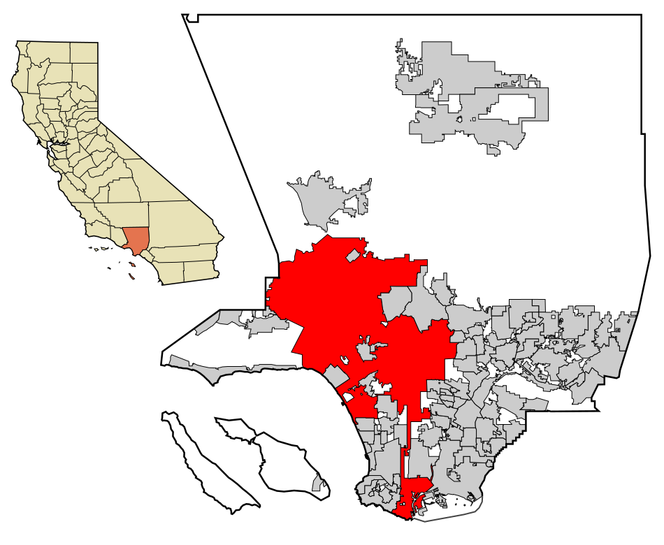
San Jose, too:
That’s largely the result of the aggressive annexation policies of a city manager in the 50s and 60s. I dug this out of wiki a few months back in a similar discussion:
I’m looking at the airport on Google maps and at the Wikipedia article. Where the hell do they get 54 sq mi? My ruler (if I square off the area Google maps outlines) says 25 sq mi tops. Are they adding in all the land from the “square” all the way to Denver’s normal city limits? That’s disingenuous.
Never mind - it’s Google’s badly drawn legend. It’s is not accurate enough to do area measurements.