Did late 17th century passenger ships from England take a similar route as Columbus to America?
I’m specifically thinking of ships sailing to Virginia or the Carolinas. According to my reading they seemed to have hugged the European coastline down to Africa and crossed over to the Caribbean and up the Florida Panhandle. Perhaps I’m mistaken. When did more direct crossings of the Atlantic begin?
Looking at these routes of Columbus I am not sure navigation was good enough to have “similar” routes for anything beyond some basic, “go west” notion. They could tell latitude but longitude was beyond them. If they knew the Carolinas were there (already “discovered”) then presumably they could keep their ship on a more northerly line and hit the Carolinas without having to first sail to Cuba and then up.

When wind stopped being the major means of propulsion.
You have to take into account the variable winds and inability to sail close to the wind. Also the Gulf Stream and other currents.
The default assumption for anything in history should never be ‘people were stupid’, but rather ‘I’m missing some information’.
Of course later ships took more northerly routes.
This is why the above is correct, mostly.
Lots easier to let the wind and current do your work rather than fighting them.
I’d say that once navigation became really good and sailing ships were pretty advanced it wasn’t too much of a problem for a sailing ship to follow a given course (read shortest) pretty closely. Certainly weather could mess them up but I think by the end of the Age of Sail they had gotten really good at it.
I don’t know when, but they learned to follow the Gulf Stream. So they would have headed south initially, and picked up the westward currents near the Tropic, followed it north along the coast of North America, then back east again across the north Atlantic. Columbus had some knowledge of westward currents and probably attempted to use them though he may not have been at the ideal latitude heading due west from the Canary Islands.
They aren’t called the trade winds for nothing.
Keep in mind that although there was bilateral Old-World New-World Old World trade, the primary trade was a trade triangle: Old World, Africa, New-World, Old World.
Are you suggesting that if someone wanted the sail form Southampton, UK to Norfolk, Virginia, that they would sail south to Liberia then northwest to Cuba then north to Virginia?
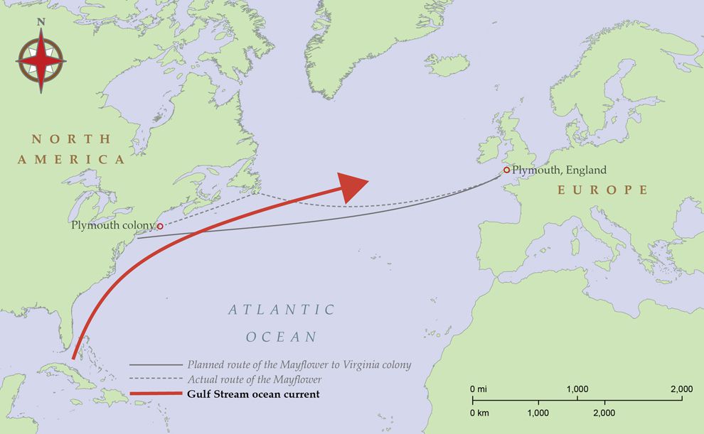
Presumably they would tack against the prevailing winds; plus, the current is stronger further northward, so as the map of the mayflower shows, initially they went a bit south-ish to avoid the worst current. It appears they didn’t stay south enough and got pushed toward north (north-east?) by the current. That just makes for a longer voyage and more tacking. The idea was - you know the latitude (but not as easily the longitude) of the place you’re going - after the first discovery - and you know longitude roughly by how far to sail. In those days, sailors were not incapable of roughly estimating where they were and how far they’d gone.
I wouldn’t read too much into that reconstruction of the voyage and which way it looks like the Pilgrims started going. It seems as late as Benjamin Franklin’s time, people didn’t fully “get” the Gulf Stream (though sailors who frequented the area certainly figured it out).
Maybe the ship’s master had some familiarity with the Gulf Stream, but then it’s entirely possible they made no accounting for that and started going directly towards VA or, failing that, somewhat to the south not because of anticipating the Gulf Stream, but because sailing captains at the time wouldn’t have had a whole lot of options to accurately fix their position mid voyage out of sight of land. Starting with a bias to the south would have allowed them to (hopefully—but apparently not, given actual conditions) reach the latitude of the part of VA they were going for prior to reaching land, and then being able to try and keep a westerly course onwards, making corrections once along that line of latitude to be reasonably sure that they would make landfall at their destination as opposed to somewhere unexpected. Anything else and… you get what they got. You get blown or pushed off course, but without being able to measure longitude, you can’t really be sure by how much until sighting land.
Which, to summarize, is why it would have made sense for them to start off in a more southerly direction whether or not they anticipated the Gulf Stream. Aim to hit the line of latitude before making landfall, because if you aim for a precise landfall, you might never reach the line of latitude and then… you’re the Mayflower.
One thing I’ve often wondered about - in days of heavy overcast or rain, was it actually possible to do a latitude reading somehow? Or were they reliant on the fact that in a few days it would be clear enough, and meanwhile they hope they did not stray too far off course…
Even if they did not know the Gulf Stream, I assume it did not take long for the sailing professionals to figure out prevailing winds.
I’m pretty sure they needed to see the sun to get a fix and determine their latitude.
If they cannot see the sun then no way to measure their latitude in which case, I think, they used dead reckoning.
It has to be a pretty nasty day if you can’t get a latitude reading at all. You wouldn’t be that far from yesterday’s latitude anyway, so it would take several such awful days before you were totally lost, but then if you survived such weather until a clearer day you’d have you know your latitude again. The lack of longitude and inaccuracies in latitude was a more serious problem close to land than out in the open ocean, leading to shipwrecks when mistakenly approaching the wrong portion of land.
Or the stars. In the northern hemisphere you simply measure the altitude of the Pole Star, and that’s your latitude.
Today, that’s true. Well, you’d get within a half degree or so. Due to precession, in the 17th century, Polaris was a couple degrees off the actual pole. But decent navigators would know how to adjust for that to get a more exact latitude.
Are you sure about that? If you can’t see the sun at midday (or the North Star at night), and/or you can’t see the horizon, how would you expect to get latitude? Particularly as one would only really know what “time” it is at local noon (in those days)?

Yes, the correction changes over the centuries, and the altitude varies slightly by hour of the night and season of the year, so that must be corrected for as well.
However, accurate correction tables for navigation had been developed before Columbus’ time.
Is there something similar in the southern hemisphere or is the sun the only thing you can use to determine latitude? (before we put satellites in orbit for navigation)
In fact, navigators of the day used a lot of “dead reckoning” anyway. Even if they could see the sun or gauge its location via the polarization through sunstone (Iceland spar), getting an accurate measurement of its angle to the horizon at noon meant someone had to take a bunch of measurements with a quadrant and hopefully find the apex. The North Star is more reliable (hence, Caeser’s line of “I am as constant as the northern star,”) but you need a relatively cloudless night to find it and seas that were calm enough to not pitch the relatively small ships of the day.
The Kingdom of Portugal undertook a large scale exploration project in the 15th Century to map and better understand the characteristics of the Atlantic Ocean currents, seasonal weather patterns, and celestial motions, developing a large body of scientific data and leading to dominance of Portugal as an imperial power during the early period of the European “Age of Discovery”. Magellan tends to get all of the press but he, like other navigators of his era, used records of previous voyages and what we would now call models of ocean dynamics to navigate for thousands of miles out of sight of land with surprising precision. Duarte Pacheco Pereira is a mostly forgotten name today but in the context of the era he was as influential as Pytheas, Chang Heng, or the later Alexander von Humboldt were in theirs, and he and his contemporaries established exploration routes that would allow for accurate broad ocean navigation of the Atlantic and Indian Oceans before the development of the marine chronometer and ability to accurately calculate longitude.
Stranger