Far as I can tell, Zip Codes are contained without County boundaries. Are there any exceptions, Zip Codes that comprise parts of more than one county?
A number of zip codes are assigned to federal military bases, some of which do cross county lines. For example, 28307 is assigned to Fort Bragg, which is located in Cumberland, Hoke, Harnett and Moore counties in North Carolina.
Marble Hill in New York City is politically part of New York County and the Borough of Manhattan, but is physically part of the Bronx. It was cut off from the rest of Manhattan by the construction of the Harlem Ship Canal, and the channel that separated it from the Bronx was later filled in. It is part of the Bronx zip code of 10463, which thus contains parts of Bronx and New York counties.
Northville MI. On the border between Wayne and Oakland Cos.
Yes, lots of them. ZIP codes refer to delivery routes, not geographic areas, and those routes can wander back and forth across county or even state lines.
For example, Fort Campbell (U.S. Army installation) straddles the Kentucky/Tennessee boundary; the entire fort uses ZIP 42223 and “Fort Campbell, KY” as the delivery address, even though part of it isn’t in the Commonwealth of Kentucky at all.
Similarly, 59221 refers to the delivery area served by the Fairview, Montana, post office, part of which is in Richland County, Montana, and part of which is in McKenzie County, North Dakota.
Closer to (my) home, “Wellsville, KS 66092” could refer to an address in Franklin, Douglas, Johnson, or Miami counties, because the delivery routes run out of that post office cross into four counties. The City of Bonner Springs, Kansas (ZIP 66012) is physically located on the Leavenworth/Wyandotte County line, but addresses on both sides of the line use the same ZIP. (In fact, an address that uses the Bonner Springs ZIP may be located in within the city limits of Basehor (Leavenworth County) or Edwardsville (Wyandotte County) too, because delivery routes don’t necessarily reflect city lines in areas where cities are expanding.)
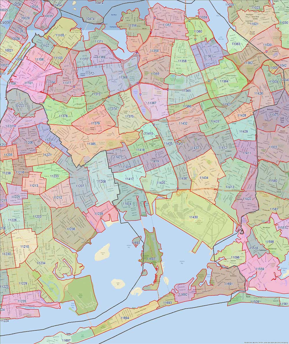
There are a couple on the boundary between Queens and Nassau County in New York. (The black line is the county boundary.)
I found zipmap.net. Put in an area code and it will show it’s boundaries on a zoomable map. I put in mine to look at Monroe County in New York.
Almost every zip code that hits the county border slops over a bit and lots of zip codes from the surrounding counties have bits inside Monroe County. I counted fifteen multi-county zip codes. Same thing for Onondaga County, which contains Syracuse. I’d assume this happens everywhere.
27587 Town of Wake Forest, NC is in both Wake County and Granville County
Sent from my iPad using Tapatalk
Cool! Thanks, everyone! I was guessing otherwise, but happy to learn the facts. It would have been convenient (workplace) to have a fixed relationship, so that a Zip Code always pointed to only one county – and I’m guessing that’s more common than not – but I’ll now know not to depend on it. Thank’ee again!
This question is asked on the post office site. They say that not only do they cross county lines, but they cross state lines. They do not give examples; however, I’d guess that the New Madrid Bend are in Kentucky might be one place.
Can ZIP Codes cross State, County, political jurisdictions and metro areas?
Yes they can and do, however, this is not the norm. ZIP Codes rarely cross state lines but do more frequently cross county lines. You can see this yourself by viewing a ZIP code map. The reason for this is that ZIP Codes are service delivery areas and do not necessarily need to adhere to other geopolitical boundaries. For example, it may be more efficient to service a particular area from one post office even though it is in a different State or County.
The mention of Fairview, MT gave me another idea, and sure enough, all of Yellowstone is 82190, despite containing parts of three different states. It’s also a radically-different number than nearby parts of Montana (though in line with the rest of Wyoming).
I am in a zip code, which is the same zip code as the people across the street. Yet they are in a different county. Their kids go to different schools.
So yes. Zip codes cross county lines.
I just looked it up and yes the 38079 Zip Code services both Kentucky and Tennessee around the New Madrid Bend
Where are you looking that you got that idea?
Just looking at my own ZIP code, 76177, I can see that it is in both Tarrant and Denton counties.
Well, I guess I was not looking at 76177.
My own zip code, 12303 is in both Albany and Schenectady County. In this map, I-90 roughly marks the border. Zip code 12304, adjacent, also is in two counties.
Zip Codes were designed for the convenience of the post office. Sometimes a certain PO covered a two-county area.
In some places (notably, the UK), ZIP Codes are actually delivery routes rathen than delivery areas (as they are in Aus and the USA). In Ireland, which more recently got a modern system (because they never used to have zip codes at all), zip codes are linked to delivery points, rather than areas or routes. This allows the PO to change both the delivery route and the mail sort, without changing the zip code.
In the UK, where zip codes are (were) delivery routes, you can’t (couldn’t) easily change the delivery route of an address: you can’t easily decide to re-balance your delivery by changing an address from one postal route to another.
In Aus, where zip codes are (were) delivery areas, you couldn’t easily split a post code when a town grew up, because mail would still come addressed to the old address, and would be sorted to the wrong delivery area. But Aus doesn’t actually use zip codes any more, except when they can’t read the rest of the address. Mail is actually sorted by delivery point, and the zip code is mostly just ignored.
The city limits of Wisconsin Dells, Wisconsin, sprawls out into five counties, and the whole city is in the same 53965 zip code.
There are even a few that cross state lines, but not many. Farmington, Iowa, 52626, flops over into quite a bit of Missouri.
Maybe we’re using the terms in slightly different ways.
In the US, a ZIP code refers to a set of addresses served by a given post office (a post office may serve several ZIP codes, but I’ve never heard of a single ZIP that is served by multiple post offices). That set of addresses may include post office boxes, individual businesses, and/or carrier routes, but in any case it is described as a set of points and lines.
The ZIP code maps referenced by several posters above are unofficial attempts to turn those points and lines into polygons (the lines describing the carrier routes served from Post Office X are enclosed by Polygon Y, which does not enclose any points or bisect any lines from Post Office Z).
The set of addresses within a given ZIP code is further broken down by 9-digit ZIP codes, and the “plus-4” section will correspond to no more than a city block or a discrete section of a rural route, so rearranging carrier routes while keeping the same ZIP code is no problem. (Last year 66607-1201 thru 66607-1353 equaled a given carrier route; now that route encompasses only 66607-1201 to 66607-1299, and the 13xx series belong to a different carrier route [contrived example].) The plus-4 section can refer to an individual business, a particular floor of an office building, a specific post office box, or some other small unit, and there is also a further “plus 2” that refers to a particular delivery point (an individual mailbox, e.g.) if the ZIP and ZIP+4 don’t get down to that level. Theoretically, every single delivery mailbox in the U.S. can be uniquely described by a 12-digit ZIP, including a check digit, although these are normally used only for Intelligent Mail barcodes.
For example, ZIP 66612 covers various offices and carrier routes in downtown Topeka, Kansas; “TOPEKA KS 66612-1588” is specifically for the Dept of Revenue. Meanwhile, “66612-1505” is the generic 9-digit ZIP for various offices in the Docking State Office Bldg, but “66612-1582” is specifically for the Board of Tax Appeals, “66612-1584” is for the Division of Alcoholic Beverage Control, etc.
For historical reasons, a post office need not correspond to a town in the first place, although they usually do anymore. When the country was young, a post office in a rural area might merely have meant somebody’s store, or even somebody’s living room, with the Somebody agreeing to receive and send mail for their neighbors. Even today, “Shawnee Mission, KS” is a single post office, headed by a single postmaster, even though there is not and never was a city called Shawnee Mission (there is a City of Mission and a nearby but not adjacent City of Shawnee, plus a dozen or so other cities and towns that are administratively part of the Shawnee Mission Post Office, all using ZIP codes in the 662xx range).