Wiki’s list of islands by area says that an island of 7103 square miles would rank 95th in the world.
And don’t forget the circling mountains around Florida and Louisiana…
Yup, and that’s a good reason for a map to just fade off into vagueness on the edge with a label of “Terra Incognito”, or “Here be Dragons”. That’s perfectly fine. It’s still no excuse for blunders like that one.
Some Captain told him “we sailed up there for many miles and never found the end. Baja is probably an island.” I wonder who told them about the strait at the end of Vancouver island, and they just "“connected the dots”? Or was that San Francisco Bay that “we just popped into the bay and couldn’t see the south end, but those could have been islands toward the south?”? There’s an awful lot of Islands where there really should only be the tiny ones like Catalina. Seems like something about scale and location got lost in translation all up and down the coast.
Also, I assume, “forty acres and a mule” as an appropriate farming starter kit…
Toronto’s main streets are still laid out as a 1.25 mile grid, and farms were strips half that length running east-west. Towards the east in Scarborough it changes to a half-mile township roads. To the west, they rotated the grid.
In architecture school we spent about two weeks on this. They told us that meets and bounds were used largely after Ohio was settled. That Ohio was the last state that had legal definitions of parcels that sounded like an old western: "My land runs from the crest that thar ridge line, clean down to the river. Bill owns the parcel west of that bend in the river, my eastern boundary runs from the third peak to that boulder over yonder. Right now the boulder is dry, but come Spring it will be in the middle of the river and half under water.
West of Ohio, the professor used the term “Rectangle States” and explained that the meets and bounds were very precise compared to “landmark” properties where rivers may change course, boulders may move or be broken to pieces, and even huge significant trees may die. The legal description in the rectangle states sound like this: Beginning at a point five miles, zero minutes, zero seconds East of the Prime Meridian for ______ and South of [some other type of line which I have forgotten the correct term for] and extending due East for Thirteen-Hundred Twenty Feet Even, from that point due South for [a distance], from that point West, North West at [a compass reading] for [a distance], from that point West, South West at [compass degree] for [distance]. I put a concave Southern border in because a perfect square or rectangle was far too simple for the final exam. The other big deal was to be sure to close up the boundary-- it had to end exactly where it started because any small error was a catastrophy waiting to happen! [Edit: I had to look it up but Base Lines are East-West lines one measures from.
They made a point of mentioning that initially ALL of the parcels were perfect squares or rectangles unless a state boundary or geological formation made that impossible, but that folks have subdivided things and not always at perfect right angles. Property rights in specifically California was older than the meets and bounds system because the Western Coast had been settled for quite some time before that system was invented. Also, throughout the Southwest there was the problem of Spanish Land Grants that were legally binding and tended to mess up the system. My last comment is that we were also told that legal descriptions in New England were always as thick as a phone book and that apparently there was not one square foot of land that was not in dispute back to the first Thanksgiving. I believe there were also examples of flowing water changing course and someones barn ending up on their neighbor’s land since the legal description specified the middle of the river/creek/waterway.
Sorry that was so wordy (I really shouldn’t post after I am this tired), I hope it is understandable.
Kron, why are you (or you employees) dragging a Three-Hundred foot chain?? [**].
How close is my memory to reality? I aced the class, but that was decades ago and I haven’t even thought about the matter for fifteen or twenty years. While a legal definition was always a small part of the Construction Documents, we tended to rely upon the street address that was also provided (and printed on every sheet).
[**] The correct answer I have been told, is that: “It is damn near impossible to push it!”
Metes and bounds is the system of going point to point: “From the POB, run north 45° 02’ 16” W 400 feet; thence run south 17° 12’ 45" W 60 feet…"
The “Rectagular” system is the PLSS mentioned above. A parcel in that system could be described as “The north half of the north half of the south half of the southeast quarter of Section X, Township Y, Range Z.” It can get more complicated when folks start selling off thin strips of land to their neighbor: “The northern 40 feet of the southern 120 feet of the north half of the north half of the south half of the southeast quarter of Section X, Township Y, Range Z.”
Thankfully, GPS works quite a bit better than chaining does nowadays ![]()
In the PLSS, you can potentially describe something simply as a portion of a Section (or Sections) as Hypno-Toad laid out:
- “All of Section 8…” (640 acres)
- “The Northwest Quarter of Section 8” (160 acres)
- “The Northwest Quarter of the Northwest Quarter of Section 8” (40 acres)
- “The Northwest Quarter of the Northwest Quarter of the Northwest Quarter of Section 8” (10 acres)
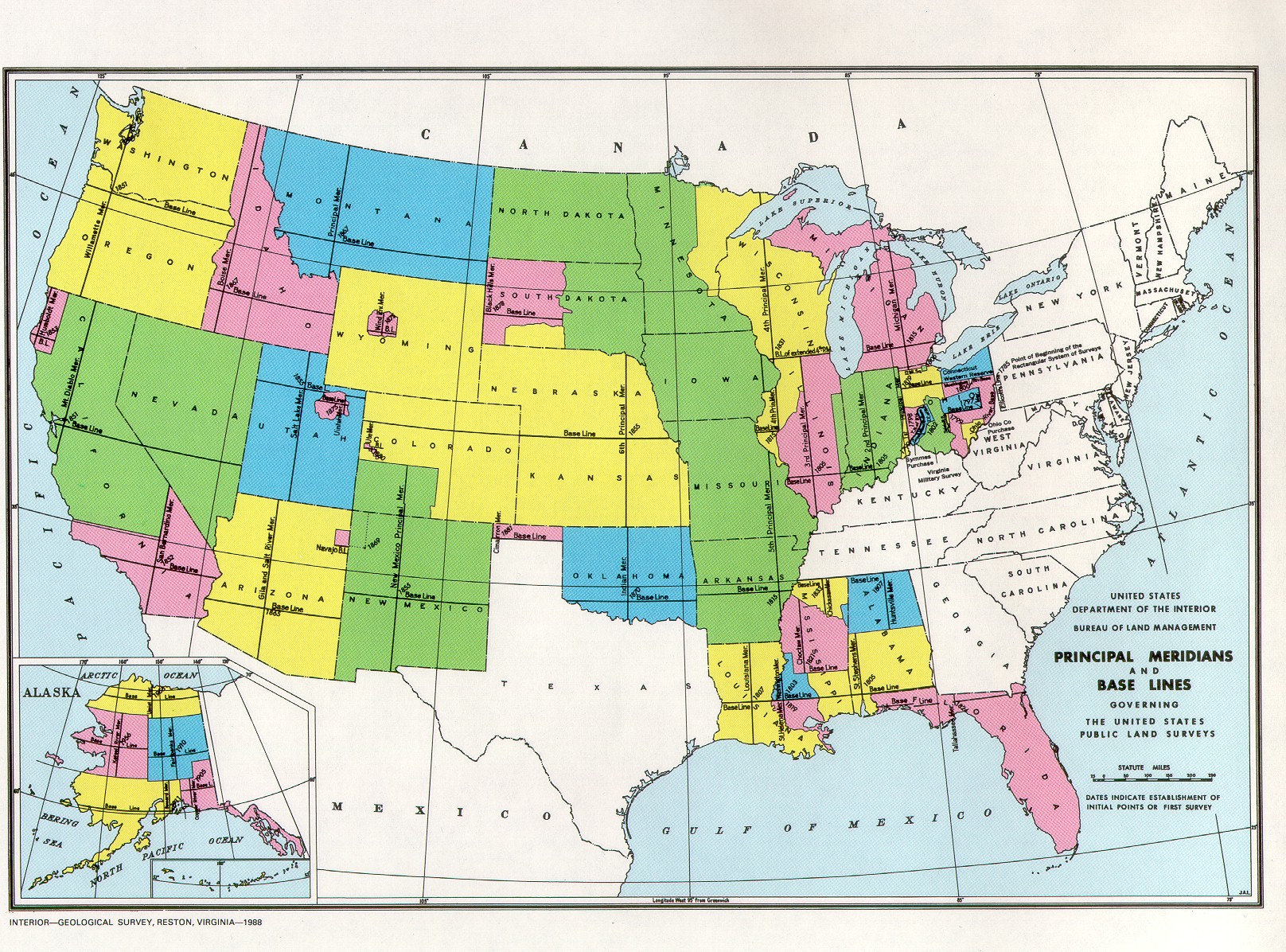
The “Meridian” you mentioned is what determines your township and range; they are referred to as “Principal Meridians” (there is only one “Prime Meridian”, at 0° Longitude). Each region of the PLSS has a Principal Meridian (north-south) and a Base Line (east-west); any township is measured as it’s ordinal position and direction from those two lines; so Township 1 North, Range 1 East of the Kron Meridian would be the the first township on the north side of the base line and east side of the meridian.
Meridian layouts:
Of course, all of this stuff in the west was set up in the 1800s/Early 1900s… Sections aren’t generally laid out perfectly, and the methods available at the time weren’t always absolutely perfect. The limitations were understood at the time, so the system has an in-built error-gathering mechanism. During original layout, the township divisions were laid out first, then the subdivisions done starting in the southeast corner; all “error” is gathered along the north and west boundaries, so if you were somebody granted a homestead in one of those “40s”, well, you may have gotten lucky with a lot that is larger than 40 acres, or unlucky with one that is maybe half-sized. Add to that the fact that just like today, some folks were just shit at their job, or pocketed the money from the US Government and proceeded to just make shit up, you can find some really WEIRD artifacts sprinkled throughout the West.
Of course, fewer and fewer people need or want forty acres nowadays; cities divide things into much smaller areas that have little-to-no consideration for the PLSS; but even then, the official description will be tied to the PLSS through the description of a subdivision; you might just live in Lot 32 of Block 8 of the Eagle Hills Subdivision in Wahoo, Idaho, but that Subdivision is likely to be “the East 1/2 of the Southwest 1/4 of the Southeast 1/4, and the Southeast 1/4 of the Southeast 1/4 of Section 17, Township 3 North, Range 2 West, Yahoo Meridian”
An understatement when it comes to the Rocky Mountains.
I do have a map of Colorado from 1873. Three years before it became a state. It’s incredibly cool. They did realize that the State isn’t square due to the curvature of the earth. And the city of Denver is laid out in a NE to SW pattern due to the South Platte river. And I’m sure railroads. Nothing square there at all. You can imagine what mountain towns look like.
I forgot, the other main way of recording parcels is a Recorded Plat. This is a chart or map of the parcels with the dimensions and registered points to allow for precise location of survey markers. This is supposed to be recorded in an official government office. My county uses “Plat Books.” The official legal description of the parcel is thus something like, “Lot 6, Block 15 of Scammer’s Swamp Subdivision, Recorded in Z County Plat Book X, Page Y.”
The County Clerk and recorder does that. All parcels will have bearing and distance on the lot lines for a recorded plat.
We own/ed two 1 acre parcels next to each other. We decided to vacate the property line between them for tax reasons and also for selling it in the future.
We had to have it surveyed, and a re-subdivision plat filled with the Clerk and Recorder to join the two lots together under one schedule number.
There are all kinds of problems that might slow this down. For instance almost all subdivided properties have a general utility easement running down the property lines. If there where utilities on that vacated property line, we would have had to grant a new easement. Probably would have to file that separately. Not sure. As long as it was on the new plat, we would probably be ok.
It varies from place to place. Down here, you have to get a Development Order to subdivide your land if it’s being divided into more than 4 pieces.
Thanks for all of detail and clarification from the experts.
(Kind of sad to realize there is yet another area where I was once fairly competent but now hopelessly ignorant. We had to learn stuff about links and furlongs and it seemed like I had a good grasp on it at one time. Once I worked in the field we just received the description from the client and plugged it in, occasionally a consulting Civil Engineer might contribute but it was never anything I ever dealt with in the real world. I was a top performer back in school-- now I couldn’t even pass the test. Every bit of detail is appreciated.)
A few things I do recall: I seem to recall that there were also run-of-the-mill, ordinary Meridians besides the Principal Meridians that were recognized by the officials who were in charge of such things. Often they were not far geographically from the Principal ones. I don’t recall for sure, but it seems that they may have been established because the Principal one was great for going North – but there was a river or mountain or some other obstruction so they made a better reference point that made more sense for going South (or East-West as the case may be). That might not be the reason at all, but we believed it back then. We were shown, or perhaps even given handouts of maps similar to the one that Kron provides, except the blow-up of a smaller portion showed additional “official” lines in both North-South, and East-West.
Also, we have some major and even a few minor roads (in obscure towns) named Baseline Road or Meridian Blvd. At least it was easy to identify the origin of Power Line Road as a child, but I had no idea that roads I sometimes was driven on had such import to the ownership of land.
In a different setting, I was taught that the brass circles in a ring of concrete that occurred in our asphalt streets were used for surveying. They were not only vitally important for location, but also for elevation as rules for how much water a neighbor had to retain before he or she could discharge any rainwater, and at what distance below a pad (dirt upon which the building is built) or finish floor (just what it sounds like) water was to be discharged from the property. That became important on a fire rebuild where everything had to come up to current codes. A slab had to be raised several inches to meet new codes – plus water retention ponds and underground tubes needed to be installed. Also, on a different job, a misplaced fence a few inches off a property line caused trouble with setbacks which could have involved re-establishing the lot lines by surveyors using the brass starting point.
I do not want to distract from the actual question asked in the OP, but would love to read more details about surveying and property lines if you folks are willing to share more of your expertise in another thread. As with most things, I am most interested in how things were done back in the day, and only then learning how new technology allowed us to skip several steps to get a perfect answer. (There is nothing I find more frustrating than a black box that can give the right answers – but which I do not understand at all.) Thanks again for the lessons learned! (Well, partially and haphazardly relearned.)
Sounds right Hypno-Toad. A division would go to planning in this county. This was a lot combination though. We own both lots and they are adjacent. Planning did not need to get involved. The term re-subdivision is sort of misleading. It might actually be an Amended Re-plat.
I have to share this. Had a plat named “The final re-plat of a re-subdivision of the 2nd filing of the second amended re-subdivision of XXX subdivision re-plat.” Had a chuckle about that. The ‘Final’ in the title just cracks me up. “So you’re sure now? Really?” That will be the legal description of the property/s. And of course lot and block number.
And while the FQ was answered (at least IMHO) this has got side tracked. I’m as much to blame as anyone.
Also don’t forget about the curvature of the Earth. If you lay out townships every 6 miles along some line of latitude, and then lay out 6 mile townships in the next row south of those, the boundaries won’t line up exactly, because the south end of a “square” (with sides running along latitude and longitude lines) will be longer than the north end. Or if you do make the edges line up, then the more southerly ones will be wider.
To someone like myself, the thread title question is answered as “a little more than two Puerto Ricos”.
So, no empire, but substantial.
Yup. They get offset. They seem to just sort of fudge sections. None can be absolutely square. (they wouldn’t stack either).
But back in the day when they had bearing trees, and counting the revolutions of a wagon wheel to mark a mile, we got this. Did a damn good job IMHO.
Colorado is considered a ‘square’ state. It isn’t. Not because it is sort of a rectangle but there are a few ‘oh shit’ moments on the state boundary where it zigs left or right for a few miles.
Even today, with all the tools we have, surveying can be an inexact science. When you get a new puzzle piece that does not fit with the old ones, what to you do with the accurate piece. A surveyor could answer this better but we rely on historical monuments. And prescriptive rights come into play too.
Nobody want’s to fix it. We have a 'subdivision wherein the Government divided up some land into smaller parcels based on the section system. 1/4- 1/4 -1/4 sections and gave to veterans for their service. Again, note this is the mountains. A nice hunk of land. But you can’t build roads in the mountains based on square lots.
We will be dealing with that mess forever. I just want a town to annex it out of our jurisdiction.
“Otisburg?”
An example I just pulled of actual townships out of my GIS software:

You can see the offsets along the east-west lines that occur every 5-6 townships. Those are to account for the curvature. You’ll see all sorts of random offsets in other areas too, as well as areas that are not really part of a township for… reasons. That big irregular area in the lower right of that image was once a lake, but is basically just dry ground nowadays (though it is a National Wildlife Preserve).
Yes, the north boundary of Toronto (Steeles Ave) the main streets east and west of Yonge street are offset a small amount. Some say earth curvature, some say the surveyors were having a bad day.
Zoom in on the north-south boundary on the east of Saskatchewan and you will see the “straight” line is actually a series of step.
I attended a lecture by a geologist who went to Russia just after the fall of the Soviet Union to see about mining ventures that the West could cooperate in. He said one major impediment to commerce was the land registry system. In a situation where the government had owned all the land for 70 years, the title system had not been updated since tsarist times, and the titles were like that - “from the big rock at the fork in the road, go 50 paces east and 100 paces north…” Western companies saw it as risky to invest in things like mines or smelters without uncontested explicit title to the land.
I understood that reference.