In a fantasy game I’m playing, a friend of mine is being promoted to the nobility and given dominion over a 7,103-square-mile island. How big is that in comparison to real-world analogues?
Shikoku, the smallest of Japan’s main islands, is about 7,300 square miles. It’s also about midway between the size of Connecticut and New Jersey, and slightly more than four Rhode Islands. If you go by medieval population density of between 30-120 people per square mile, your friend might expect to have somewhere between 200,000 and 850,000 people in his realm, assuming this island is as developed as medieval Europe was rather than a colony or uninhabited island.
Massachusetts is 7,838 sq miles if that helps, Fiji is 7,095 square miles
Somewhat smaller than Wales…
That is an oddly exact number ![]()
Especially given the accuracy of medieval measurements.
If your island is somewhere between 82 and 85 miles on each side (and assuming a square island, so yes, we’re in an “assume a spherical cow” type of oversimplification), its area will be somewhere between 6,724 and 7,225 square miles. Even that would be exceptionally precise by medieval standards.
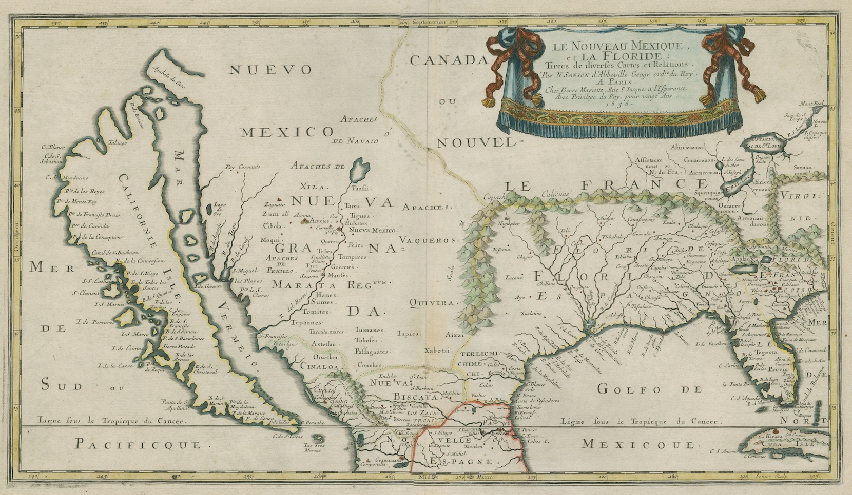
As for the accuracy of maps in ye olden days, I always like to point to this early map of America which very clearly shows the island of California.
Unless this island has a well-established history, I think your newly minted noble’s first task should be to take a group out around his new island and survey what he actually has under his dominion.
I assumed the size was rolled up.
It’s about twice the size of Yellowstone Park or Voyagers Park.
Or smaller than Israel but bigger than Fiji.
It’s a bit smaller than Riverside County, CA and a bit larger than Siskiyou County, CA. (Siskiyou is a bit larger than Fresno County.)
The big question is what % of that is arable land, are there minable ores, etc.
To bring in an analogue from an era of history that fantasy role-playing games often borrow ideas from: The county palatine of Lancashire, main base for the power of the House of Lancaster in the Wars of the Roses, had less than 2,000 square miles. So I’d say more than 7,000 is failry big for such a setting.
But there was income from farmland, fishing, tolls and tariffs on trade, and so on. What’s the climate and soil like on this island, and are the people contented serfs or mutinous bandits and outlaws?
For reference, a quarter-section (half a mile by half a mile, so quarter of a square mile) is 640 acres. This is usually how farms were parceled out when the west was settled. Ancient farms were much smaller.
Simplest way to figure is by rule of thumb - 7,000=70x100 miles. That’s a LOT of land, especially if a lot of it is arable, and especially in the days before automobiles. Figure a person on horseback might do 30 miles in a day, armies normally might march 20 miles in a day.
Of course, in Ye Good Olde Days, that was not an estate - it was a domain which is then subdivided among vassals who subdivide it among their vassals, depending on how many individual lords each uber-lord managed. Each layer of lordage gets their take. As a result, your high mighty lord only gets a fraction of the total take from the peasantry or peonage.
At first, I read this as “mutated bandits”. Which, depending on the game, might also be plausible.
Even by the standards of “ye olden days”, that’s an absolutely terrible map. Sure, there’s always going to be considerable error in longitude, but any halfway competent explorer/map-maker should be able to get latitude spot-on. And what sort of explorer, on encountering a feature like the Gulf of California, wouldn’t follow it all the way to the end, and accurately note the latitude of that end?
Less obviously, but just as egregiously, what are all of those rivers branching out from New Orleans? Anyone who even knows there’s a river coming out there is also going to know that there’s one and only one main channel going up a good ways upstream.
No, a whole section (1 square mile) is 640 acres. A quarter section is 160 acres. Source: over 20 years of land surveying.
ETA: Sections were subdivided one step further, into sixteenths (40 acres), which was considered the smallest piece of land anybody would want. That was the original size of homesteading claims, and usually when you look at the original government patents, each is for a description of one forty-acre parcel (the NW 1/4 of the NW 1/4 of Section 8, for example).
It’s about 151 San Franciscos, or if it’s a square plot, about 84x84 miles.
Doh! that’s what I get for being a city boy. I used to know that.
In ye goode olde days, reference libraries were scarce and limited. Not every explorer was motivated to follow am inlet/strait scrub desert area all the way north. I wonder how many math errors in ships logs? So they guy filling in a map just made it up as he went along, unless he was the person who went on the voyage - plus doing a large area map was probably some guy sitting back home trying to chase down assorted captains for their log information, and copying other areas from previous, equally inaccurate maps.
I took a computer cartography course years ago, and the prof mentioned digitizing the maps of northern Ontario that the map division had - and when they reconciled them to satellite they found a lot of survey errors of up to a mile or more - and that’s with early to mid twentieth century tech.
Yup. 30 years in GIS. It’s called the PLSS or - Public Land Survey System
We used to own a 1/4-1/4. 40 acres. 1320 feet square. So it was a mile to walk around it.
If in an airplane flying over interior states you will often see grids of country roads. They generally follow section lines or a subdivision of them. Depends on the lay of the land. You won’t find this in the East coast though. Not sure about Texas and California.
You also see it here in FL since much of the peninsula was surveyed at the same time as the west. I specifically remember learning about the PLSS in grad school and thinking, “Man, talk about knowledge I’ll never use.” So I get a job afterwards in S FL and sure enough almost all of the deeds I have to look at for my planning job are based on the Townships and Ranges, even the metes and bounds descriptions since they usually chart their Point of Beginning from section corners.
Hence, the “forty” you hear in fictional (or real) farm conversation, like “I still need to plow the back forty before supper.”
Yup. If your lucky. I’ve seen 100 year old deeds referring to a monument called the bearing tree. It’s a tree, and is long gone now.
35 years ago I worked for a survey company. Even that long ago, we switched to environmentally friendly survey tape. Soy based. Marking the property before the actual survey and setting monuments so we could find them later for addition work, we used this tape.
Deer apparently find this soy based tape quite tasty, and easy to find “Look! They left us snacks!”
Lake Ontario is 7320 square miles. That’s pretty close. (Fiji, already mentioned, is darned close, but if you need a reference point in North America, there’s the lake. Though, maybe aquatic reference points aren’t quite as useful or intuitive for land.)