And how did they, back in the days before laser sightings and GPS assistance?
The Mason-Dixon line was pretty straight, and pretty accurate. How did they make this happen using only stone knives and bearskins? (Or whatever surveying tools were in vogue in 1767?)
Transits, measuring tapes & rods & wheels, trigonometry. Nothing particularly complicated and with good attention to detail you can get very accurate results.
When I was an undergraduate CE I took a surveying class, we didn’t use anything fancy (no lasers, no GPS, etc). We even did stuff like figure our standard pace and use that to estimate distances.
The part that baffles me is that it is all done on an extremely uneven surface. Hills, holes, trees, rock outcroppings,man-made terrain changes, buildings.
I truly have no idea how surveyors “cut through” all of that with simple tools.
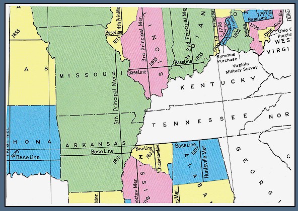
I’ve always been fascinated by the precision of surveying over long distances. The 5th principal meridian covers much of Missouri and Arkansas. Laid out by the surveyors of the Louisiana Purchase and its very accurate. Quite a few important baselines intersect with the 5th principal meridian.
There’s a story, possibly apocriphal, that the city blocks of downtown Stockton are an odd size because, when the surveyor’s chain* broke, the blacksmith not only repaired it, he added a new link for free. They are 303 feet long, rather than 300, but it could still be an old engineer’s tale.
The uneven surface is dealt with using trig and sight lines to measure the elevation. It’s all triangles. Here’s the pole that would be used with the transit.
If you’re interested, you might look into taking a community college course in surveying. They’ll either use the old tools or teach you how the old tools worked. You’d think there would be good websites for the basics, but I’m not seeing it.
The big reason that computerized laser equipment is used now is that not only does it save the time of calculation for the surveyors, the results can be downloaded into CAD software directly, saving hours of drafting. And time is money.
*A chain of a standard length between two poles or with hand-grips.
The Mason-Dixon Line is fairly easy, by virtue of being a line of latitude. You can determine your latitude quite precisely at any point using astronomical observations. Pick the latitude you want, find as many points as you want at that latitude, and then connect them all.
This article has a great map showing the British survey of India. It has all the triangles on it. If you click on the map in the corner you get larger version. That version allows you to get the original file which is a really high resolution copy of the map. It is great to see all the triangle over India and the triangles used to determine the heights of the big peaks in the Himalayas
I’ve wondered what happens when a building project needs to disturb a surveyor’s benchmark? How do they get permission to remove it and then does it have to be replaced? Like in the middle of the new hotels lobby?
Picture here. If each link is 66/100 foot long, the expanded chain would be 66.66 feet long. That’s 101% of standard. 303ft/300ft is also 101%. So it’s possible, or at least plausible. The old engineers could still be yanking our chain, of course.
aceplace57, most projects that disturb surveyor’s monuments have to put them back. They hire a surveyor to make several measured triangulation points outside of the project area and then use them to reset it exactly where it was.
I’m not sure what you’d have to do to get one relocated permanently. But you have to know that there are different kinds of benchmarks, monuments, and marks. Some are very local and can be thing like an X scraped into a curb or a round-headed nail with a washer pounded into a sidewalk. Others are more like a backbone for a lot of other benchmarks. The local ones are more likely to be movable than the core ones.
Because relocating benchmarks is a big problem, they’re usually located on hilltops or in street right-of-ways. They really do try to put them places that no one would want to put a building.
For your amusement, from one Record of Survey: Basis of Bearings
The basis of bearings for this survey is California Coordinate System NAS83, Zone 3, defined locally between a found 3-1/2" brass disk stamped “Calif DOT PM 14.09” at the southerly end of a culvert headwall at Caltrans Post Mile Station 14.09, and a 3.4" iron pipe with yellow tag stamped “Calif DOT” at Caltrans Post Mile Station 14.77. taken at North 15(deg) 40’ 25" West. – and then notes on where in Caltrans and County records those two marks can be verified.
At the end of the 18th century the French tried to measure the distance from the equator to the pole on a meridian in order to establish the precise length of the meter.
They wanted to define the meter as 1/10,000,000 the distance from the equator to the pole.
They sent two men on the mission tackling the problem both northbound and southbound. The actual surveying was done using careful measurements of straight line distances between landmarks combined with trigonometry using triangles of approximately 40 miles on a side.
They bungled it. The meter is approximately 0.2mm short.
By 1970ish, when I had the job of surveyor’s assistant (you think a gopher has it bad?):
How to get through the brush: machete
How to measure accurately: know the temperature and correct the chain (by then a metal tape) measurement for thermal expansion/contraction.
How to find a benchmark: in one case, someone had thoughtfully pulled up the stone used and placed against a tree for easy identification. This was a high piss-factor job about a property line in the middle of nowhere.
Go find a picture of an old optical Transit. 2 different poles were used - the scale linked to above for measuring elevation, and a “sight rod” - a red and white barred pole used to throw a line.
The transit’s scope flips over. Once the transit is on the desired line, simply flipping the barrel over projected the line with absolute accuracy - the barrel is not turned 180 degrees, just locked through the vertical axis.
When building a (smallish) bridge, once the beams are in place, the elevations need to be confirmed or corrections made to either the beams or the plans. That damned elevation pole is walked along the beams (10-12" wide, with rebar loops on top.
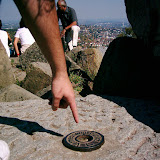
Sometimes in the road, sidewalk or at the bottom of a telephone pole I will see a gear-like thing about the size of a quarter. The gear kind of looks like this gear.
Doing a Google image search, I found one image on this site that looks like what you describe. They’re cotton spindles (whatever those are). I’d guess these are roll-your-own survey markers, but I’m not sure why someone would need that.
Ah, memories. Not good ones, but memories nonetheless. Nothing like spending the summer hacking out right of ways.
That was in the days of Dumpy levels, and the old K&E transits. We had one or two Zeiss self-leveling levels that crews would fight over. As mentioned above, you had to do your own trig calcs (on paper!) when staking out the curve of a road. Topo surveys on uneven terrain were always fun, as sometimes the rod, even when extended, wasn’t tall enough for the instrument to see. In that case, we’d do a knee boot, a hip boot, or even a top-of-the-head boot and add it into the reading; not very accurate, but close enough. I always hated it when there was some big bastard on the other end of the chain, trying to pull you off your feet while you were trying to keep the plumb bob over a tiny tack in the top of a stake.
I’ve been working in GIS (Geographic Information Systems) for 25 years.
Todays accuracy is fantastic. But it’s like trying to put a perfect piece in a misshaped puzzle. Now, I’m talking about things like mining claims that where ‘surveyed’ over 100 years ago. “Joe, that tree is the SW corner of our claim”
At least in the Colorado mountains. I doubt that’s too surprising. Surveying in mountainous terrain a hundred years ago must have been a real bitch. It was a bitch 30 years ago when I was a ‘mule’ (carried equipment).
Heh, I remember running one line using new bio-degradable survey tape. Made out of a soy product. Better for the environment! We would hang the tape to find the reference points the next time we where out.
Turns out that bio-degradable survey tape is also a tasty deer snack. :smack:
I’m not a surveyor, but one thing I found interesting - When sighting on a reference point with a transit, the surveyor would sight, make a note of the bearing, and then spin the transit and scope 180 degrees (the scope on the top of the transit could also flip over) and sight again. Then average the two sightings. (or four or eight). This is one way to minimize inaccuracies in the equipment, and the surveyors eye.
When I worked for the city I had an assignment to dig up the legislation, local and state, that created every “park” in the city. Park is in quotes because in legal terms that includes not just the giant public parks that most people think of, but every square of grassy area maintained by the city, including median strips, corner flower beds, pocket parks, downtown squares, 106 in total. Reconciling 19th century descriptions with 20th century maps was sometimes, shall we say, challenging. And it turned out that most of the downtown squares came into existence before the city was legally incorporated and that no legal description for them had ever been placed into the legislature.
One poor guy found that he had built his house unknowingly athwart the line of another piece of dedicated parkland, for which the only legal remedy was teardown. I left around that point so I never found out if they worked out a settlement. Probably did since it didn’t make the papers. But from that experience I’d guess that most of the Northeast has a million little legal issues because of the history of surveying and the formal recording or it - or lack of it.