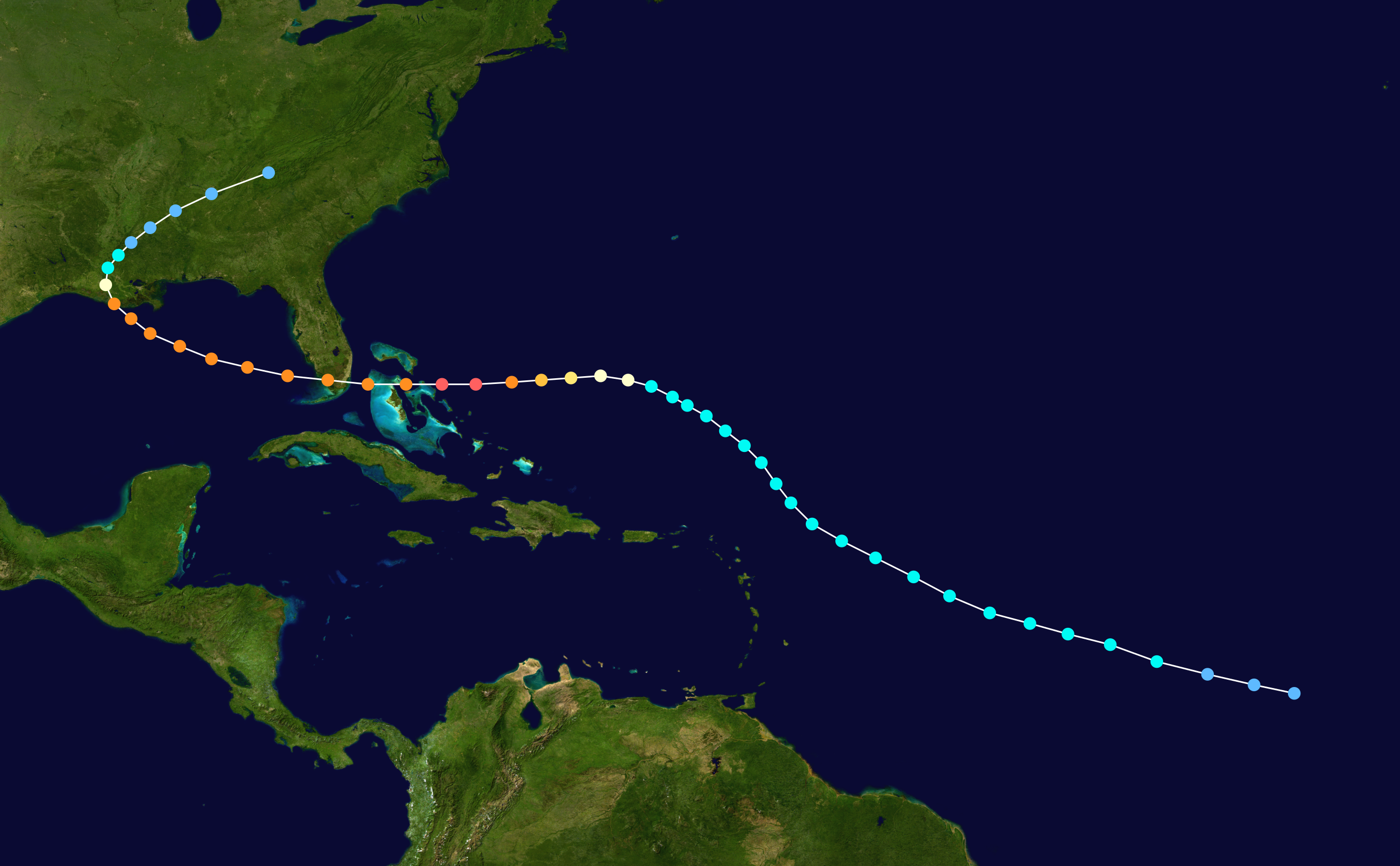
Based on my experience, I assume that hurricane tracking must be complex and involve a variety of meteorological phenomena, and still leaves us with a good amount of uncertainty. Dorian, as of yesterday, was tracking due west at 8 mph. Even as of the day before, the models all showed a medium to sharp right turn just before its edge reaching Florida. When they combine the various models, a cone of possibilities was developed, and is presumably a “confidence interval” in which the storm’s path will very likely proceed. A portion of this cone actually includes Florida. However, there must be something telling the models that the storm will veer right. What causes that turn? Why won’t the storm simply stay due west and make a beeline for Florida?
There are a lot of consistent weather patterns related to geography and large scale wind patterns that only change slowly.
Or, put another way. There’s other weather in the way.
IANAM, but I expect that there are a number of interesting weather phenomena that occur when a body of water meets a body of land, and that some of these might represent some degree of barrier to other weather systems crossing them.
Perhaps when the outer edges of the hurricane system cross the coast, the stop evaporating water into them, and that causes a sort of “trophic response” in the structure of the hurricane which turns it.
I just saw a clip from the Weather Channel about this. If I understood correctly, right now Dorian is stuck between two high pressure systems, one moving east across the north of the USA, and one in the Atlantic Ocean to the storm’s east. That’s why it has remained more or less parked over the Bahamas.
As the high pressure system in the Atlantic moves south, the path north and east will open up and Dorian will follow it, which will take it up the coast and then back out to sea and the colder waters of the mid-to-north Atlantic ocean. The high pressure system over the northern USA is also moving east and it, along with a dipping jet stream, will help push Dorian east through the newly opened path.
I think.
It requires a bit of reading through several posts, but the fine folks at https://spacecityweather.com/ have been putting up regular hype-free (none of the Weather Channel style “The Sky is Falling! Run for the Hills!” panic mongering) posts about the storm.
It’s primarily a Houston area site, but there’s been enough interest in Dorian they have decided to add information on it as well. If you go back to the posts from the last week of August, they have near daily updates explaining the latest forecasts, why they change, and try to generally explain the science in an accessible way.
That’s my understanding, as well. Highs and lows tend to move around each other, not through each other.
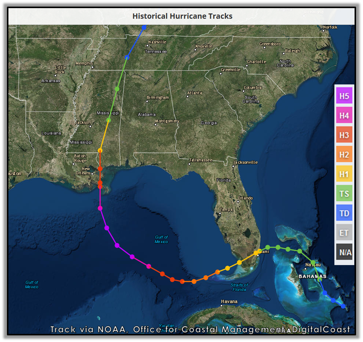
Also, the predicted track for Dorian (i.e., taking a hard right turn as it nears Florida) is a common path for Atlantic hurricanes; Great Antibob’s link to SpaceCityWeather is noting, this morning, that Dorian’s predicted track is very similar to that of Matthew in 2016. I believe that that typical northeastern curve is also influenced by the Gulf stream.
However, not every hurricane in that area makes that kind of hard right turn; no two storms are the same, and no two sets of atmospheric conditions are the same. Hurricane Andrew in 1992 just kept steaming due west, right across the southern tip of Florida, and Hurricane Katrina took a not-dissimilar path in 2005, before strengthening in the Gulf, prior to hitting New Orleans.
About a week ago, TS Erin formed in the western Atlantic and some models had it causing Dorian to make a sharp right turn. Erin’s gone off to Nova Scotia or somewhere, but maybe it still has some lingering effect.
If it helps to visualize high and low pressure areas, just remove the word pressure. The high area is like a hill or a mountain and when the low encounters it the low is not going to climb the hill or blast though it, it is going to take a path around it through whatever low area that is available.
Weather people sometimes use the word trough to describe these atmospheric lower areas. The low will take the gully around the mountain. The atmosphere has a topography much like land does.
This. As big as any given system is, the earth is a lot bigger. Depending upon whether it’s a high or low, relative size, & relative strength one system/front can either block another one or suck it into it’s path as it pulls out.
As an analogy, use a freeway. You’re in the middle lane & want to exit to go right but that vehicle there is blocking you so you slow down, or that truck that passes you sucks you into it’s wake.
Gigantic supercomputer dynamic numerical models that simulate how currents in air flow over time, given various meteorological inputs. It’s not just looking at hurricanes of the past and saying, Hurricane Bertha turned here in 1970, so this one will too.
Indeed. Most big cities have what they call a ‘heat island’ over them, noticeable by airline pilots. Caused by the concentrated population & waste heat from air conditioning, electrical use, etc. plus the sun-heated dark roofs & asphalt streets.
That also affects weather patterns over land. For example, here in the Minneapolis-St. Paul area, we sometimes have tornadoes in summer. But they are generally pushed away from the central cities by this ‘heat island’, and veer off toward suburbs. The only one I can remember hitting the city itself was in 2011, and that landed in north Minneapolis, the poorest & least-developed part of the city. More typical was the storm of 1965, when 6 tornadoes swirled around the cities, but all 6 passed through suburban areas, without entering either of the central cities.
Based on a dim memory of an anecdote from last century (so caveats galore), I was told by a geographer that a hurricane’s path at any point was essentially random. All else being equal, if it was in the middle of a flat undifferentiated area it could and would travel equally in any direction. The things that influenced the hurricane’s course had to be significant atmospheric or topographic constraints, such as regional scale atmospheric pressure systems as noted above, which of course are continually changing themselves, or mountains and hilly land which will be built into the weather models.
My experience of hurricanes / cyclones is no closer than repeat watchings of Twister, and thats just fine by me.
Well, it’s a big spinny wheel, innit? Going counterclockwise? So when its left edge gets some traction on Florida, of course it’s gonna roll right up the shore to the North. At least until it hits some kinda ramp (like North Carolina) and jumps off into the Atlantic. That’s just physics.