How much damage would NYC sustain if a category 5 hurricane hit it head on? The last time was in 1851. What contigency plans are in place?
For instruction, I’d say look to Hong Kong rather than the obvious temptation of comparison with New Orlean: Hong Kong is of similar size, beside the water, and the business district is very similar to Manhattan, though the suburbs are more high-risen.
HK is regularly hit by typhoons, graded on a different scale to US hurricanes. “Signal 10” is equivalent to a direct hit from a category 5. There have been several Signal 10s over the years. Example.
Dangers would be the wind, the effect of deluge, and storm surge.
One effect of super-high winds hitting tall buildings is to create a vacuum on the leeward side of the building, which tends to suck the glass (and occasionally people) out of the window-frames. Another is to demolish scaffolding and building debris and throw it into the street (worse in Hong Kong where they use bamboo). Anyone in the street beneath partially-completed buildings would be in serious danger.
The main cause of fatalities during HK typhoons is deluge-inspired landslides, which would probably not occur with too much proliferation in NYC, it not being terribly hilly.
A storm surge from the Hudson would be a worry, but since the buildings are so high, hopefully most would be sheltering above potential water level. Comparison between NYC and NO would not be very fair, since NO had its sea-level height and Ponchartrain to contend with.
Yes, but if the subway system was flooded it could take months or even years to bring the system back on line. This would cripple the city.
metro guy hat I don’t think this is so. There have been a number of cases in which subways have been flooded, and they haven’t taken years to come back on line. Montreal has suffered at least two flooding incidents, Paris at least one that I know of (several stations were completely filled and at least one, at ground level, was completely covered). It’s not my understanding that either case resulted in months of closure (certainly not in Montreal), though the flood on the Vltava in 2002 did close certain stations in Prague for some months.
I can’t attest to New York’s operations, but in Montreal, there are pumping facilities everywhere, since normal seepage occurs constantly (at least one station is built in the path of an underground river). Certain stations might be knocked out of commission, but it would surprise me if the whole underground network would be rendered inoperable for many months.
This would be salt water. It would play havoc with the signaling and control systems, as will as more prosaic things like lighting and PA. Also, the system is so large, and the breach would probably happen fairly suddenly, any innundation would likely cause lots of physical damage from moving water. There would be tons of mud and debis carried in with the seawater. The sheer volume of water would take weeks to evacuate. London has similar worries with the Thames.
A little fresh water seepage or even flooding in certain areas is not the same as having the entire Mahnattan subway (all below sea level) filled with corrosive salt water. :eek:
OK, I hadn’t considered that. Being ignorant of New York geography, is Manhattan really surrounded by salt water, or are the Hudson and East Rivers still fresh up until that point (pollution aside)?
Has the Hong Kong subway had trouble with flooding before?
From what I can gather from your link, a signal 10 is when the storm reaches hurricane force winds at 64kts. The track of the linked storm (Typhoon York) showed sustained wind speeds at 70kts at land fall. A cat 5 hurricane has sustained winds of at least 135kts.
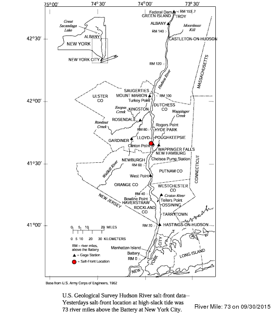
The salt line in the Hudson varies with the seasons but on average it’s salt water as far north as Poughkeepsie. Depending on the tides, the salt water can reach all the way to Troy.
The East River is a tidal strait and is all saltwater.
Don’t know about Hong Kong. If you look at a map of the NYC area you will see that it is in fact in an estuary where fresh and salt water mix. The east “river” is actually a straight that connects to Long Island Sound which is salt. In addition any storm surch would carry ocean salt water into the estuary, so yeah the water would be brine, though maybe not full strength seawater (though I would bet closer than not). If you take a boat trip out to liberty island it sure seems like the ocean to me, and is certainly salty, just as San Francisco Bay is.
That salt is going to remain in nooks and crannies and cause trouble for years, too, no matter how well they scrub it out. I wonder if they have identified the most lowlying entrances to the system and planned to put berms around them, or will they pull a New Orleans and just screw the pooch. :smack:
The other thing is that the system is flaky on a good day. A lot of it is ancient, and while they are replacing it, the new system has a buttload of sensors, etc., to enable closer headways (the only way to increase capacity), so the new system may actually be more vulnerable. As a certain fictional engineer once said “The more they overthink the plumbing, the easier it is to stop up the drain”.
Any hurricane that would flood the subway would do a lot of other damage and the impact would make New Orleans look like a picnic. The importance of the city to the economic life of the nation is far greater, and the real esate in the path of destruction is worth way more.
Currant Hudson River Salt Front
[nitpick]
Tidal estuary
[/nitpick]
New York City does have hurricane plans in place. The Office of Emergency Management has a Hurricane and Coastal Storm Preparedness website, including hurricane flooding evacuation maps.
Sorry, late to return to this thread. Scruloose, the HK government defines signal 10 thus:
matt_mcl, AFAIK HK has never had a flood of any kind in the MTR.
[nitpick]
Current
[/nitpick] 
What? But there were all those mountains in the background in Rumble in the Bronx!