I want to walk across the Golden Gate bridge.

Can someone help me plan a trip from the Sacramento area to the bay area so that I might accomplish my goal, please.

I can stay overnight, but I don’t have to. It appears to be 1.7 miles. I expect it would take me 4 to 5 hours to walk the entire bridge and back.

I guess I’ll probably drive there, but the thought of driving in such traffic makes me a bit nervous, so I’m open to other suggestions.

I’d love to have a nice dinner after my walk, so restaurant recommendations are welcome. I’d love it if they have good raw oysters.

Thanks for your help.

There’s extremely limited parking near the bridge so driving is generally not practical.

There are busses that will deposit you close to the bridge if you insist on walking but I’ve found the most practical way to experience the bridge is by biking to it. If you want to walk it, you can lock your bike at one end and do the round trip but it’s also quite fun to bike slowly across it and stop once in a while for pictures/take in the view.

As for oysters, the best place is Swan Oyster Depot but they close at 5:30 so maybe not practical. If you want a bit more of a day trip, whats quite popular is to bike to Sausalito (about 4 miles from the bridge) and then take the ferry back to the ferry terminal. Both Sausalito and the Ferry terminal have excellent food (including Hog Island Oyster in the ferry terminal which is a local institution.)

Is there any reason you expect it to take you so long? Most people can walk a few MPH even at a leisurely effort, but you’re assuming a speed of around two-thirds of an MPH.

[Moderating]
Oh, and this isn’t really an art form, so I’ll bump it over from CS to IMHO for you.

Oh, quite right Chronos. I confused myself there. I saw a cite that said the bridge was a 3.7 mile walk one way and I had done the math for that instead of 1.7 miles.

And I flubbed the forum too. I was thinking Travel.

Thanks Chronos.

I don’t have any useful OP response other than to say walking (or slow biking) the bridge will be fun. My one-time back-and-forth walk was fun. Mainly to look down and up to understand the distance to water and the height and substance of the towers. Windy, to be sure, so bring a jacket. And, I must confess, I thought more than once what a suicidal jumper must have envisioned looking down. I don’t live in SF. But if I did I would be mightily proud of the vision the bridge designers and the SF voters had back then who, (as Burt Reynolds said in The Longest Yard), “Let’s do it.”

The bridge is 1.7 miles long. So figure twice that if you’re going to walk both ways on it.

The first time I did that, it was a fabulously bright clear day and there was a sailboat regatta on the bay. There must have been at least a hundred, or several hundred, sailboats out there.

There is a parking lot at the south end of the bridge, accessible from 101 northbound as you approach the bridge, and also from the surface street (is it Lincoln Blvd?) that follows the coastline south from there. This is the parking lot of which Shalmanese writes “there’s extremely limited parking”. GFL finding a place to park there.

There is also a smallish visitor center of sorts right there. Also, Fort Point, a Civil War era fort, is right there.

At the NORTH end of the bridge there is another place to park (also accessible from northbound 101) – a vista point with a visitor center of sorts, always crowded with Japanese tour buses and people taking pictures. If you get to the Alexander offramp (the road to Sausalito), you’ve just missed it. It’s not precisely at the end of the bridge, but a short distance north of that. I DON’T know, offhand, if you can walk back to the bridge from there. Check it out. You might find a place to park there. Maybe.

For a SPECTACULAR view of the bridge, do this: As you drive north across the bridge, notice that mountain ahead on the left, overlooking the mouth of the bay. Take that Alexander offramp. At the bottom of the ramp, turn LEFT and go under the highway, then turn LEFT again. This just takes you right to an on-ramp right back into San Francisco, BUT… Immediately where that on-ramp is, there’s a road to the right that goes up that mountain. Take that. This area is called Fort Cronkhite.

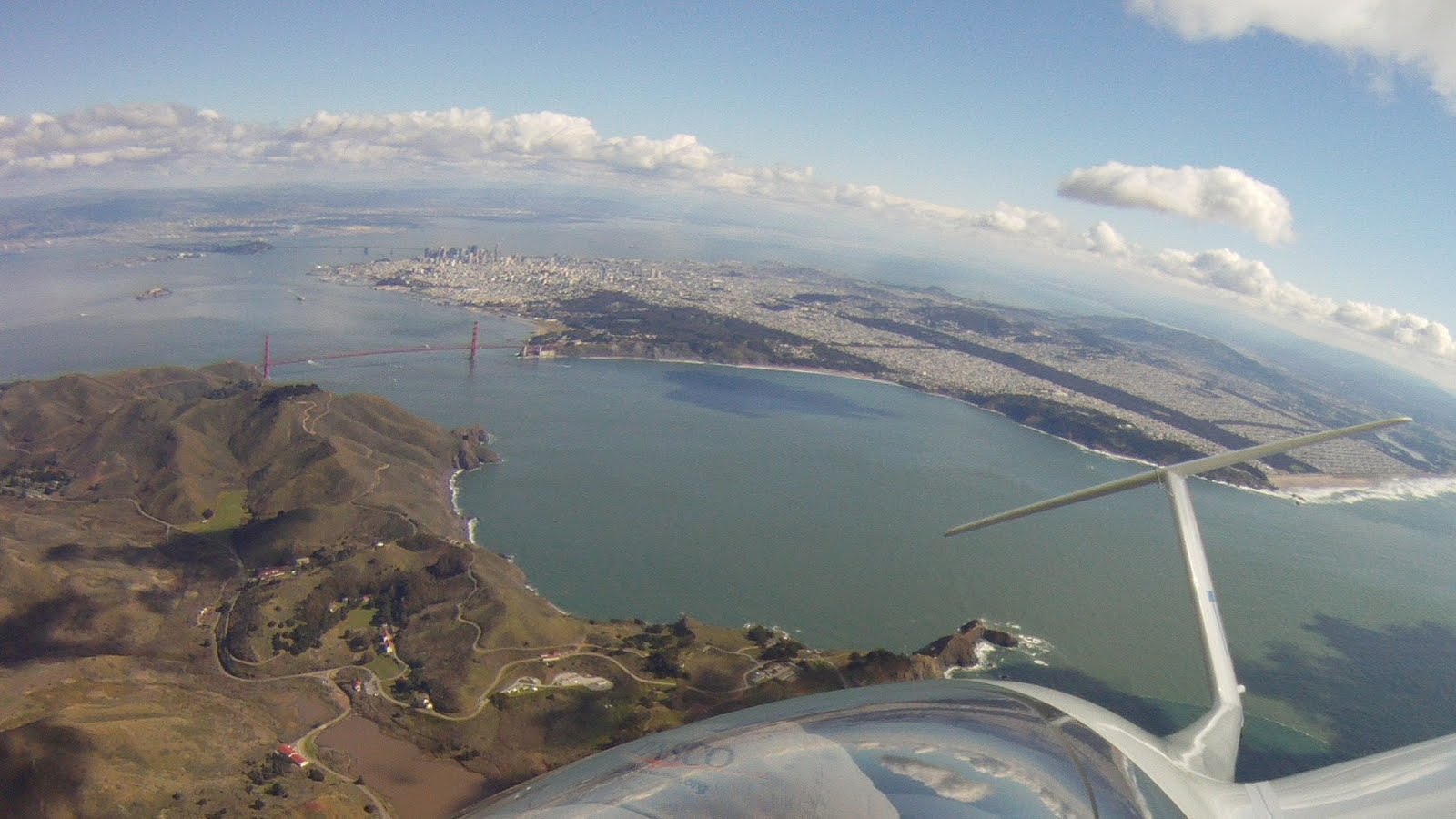
There are ruins of some WWII-era fortifications at various places along that road. There are various places to pull over and park. There’s a trail down the mountain to a small beach in a cove below. And, weather permitting, the view of the bay, the bridge, and S.F. is spectacular – just like if you were flying over in an airplane.

At the very top of the mountain is another fortification that was supposed to be a HUGE gun emplacement, only the war ended before it was completed. There are also hiking trails in the area.

Here again are some links I recently posted in another thread somewhere, a blog with some spectacular aerial photos of San Francisco and surrounding areas. The Golden Gate and Bay bridges are very visible in some of these pics.

Most of the pics you can click on to embiggen. I think you can click on them again to embiggen even more.

At the end of each blog there’s either a video or a link to a video from which those pics were taken.

First blog and video, all from below 4000 feet:

The video: XC Soaring Over the Bay Area - YouTube

Second blog and video (about a year later), all from 15000 to 18000 feet:

The video: Bay Tour 2 - YouTube

Here’s another of his blogs, with highlights from his 2016 adventures. This guy gets around! Again, lotta great aerial pics. The third pic, Lick Observatory, is near San Jose:

ETA: The first picture in the first blog above shows very clearly that Fort Cronkhite mountain that I described in the previous post.

City bus (Muni) route 28 will take you right to the toll plaza. Catch it at the north end of Van Ness, or anywhere along Lombard in Cow Hollow.

I think any Golden Gate Transit bus will also let you off, on request, at the toll plaza.

The drivers are quite used to it. Lots of visitors do this.

Public transit from Sacramento would involve the Amtrak Capital Corridor, then either changing to BART in Richmond or a bus in Emeryville to get into the City. Then Muni across SF. I’d drive.

It’s actually a formal stop on many (all?) GGT routes. I did exactly that from downtown SF a week ago on a quick nostalgia binge of catching the sights before flying home on a recent business trip (I used to live in the bay).

But if you have a car just drive. If you arrive early and make a day of it I don’t think you’ll have a hard time parking at the north overlook. Even if it’s busy I’ve found there is enough turnover to make finding a spot alright.

One of my favorite things to do when I lived down there was park at the Land’s End parking lot and hike towards the bridge, passing through the beaches and WWII fortifications. You could probably walk up to and across the bridge as part of that. That would make it closer (longer, actually) to the four to five hours you had mentally prepared yourself for :wink:

I’d usually just keep walking all the way to North Beach, grab a dinner and a bus back to the car.

The Marin Headlands suggestion earlier is also wonderful. One of my favorite spots.

All my major suggestions are already covered (Capitol Corridor, Lincoln Blvd, GGT route 101). Note that on weekends, the bay sidewalk is pedestrians only, and the ocean sidewalk is bikes only. Weekdays the bay sidewalk is shared peds and bikes (can be chaotic), and the ocean sidewalk is closed to all.

An interesting viewpoint is under the bridge. There is a stairwell from the viewpoint on the north end of the bridge going down below the roadway that crosses to the other side viewpoint, below deck. Not many see the underpinnings of the bridge up close, with traffic whizzing by just a few feet overhead.

I will add that Hog Island Oysters are over priced due to their marketing success. Expect to spend $18-$20 for a half dozen at the Ferry Bldg. You are probably better off going to one of the other places noted here.

This is the time of year to do it, too. Summers can be very cold, but autumn is the best time in SF if you’re looking for clear, warm weather. Better hurry, though, because the rainy season will be here shortly.

On the San Francisco side, maybe. The Marin side has pretty good parking. I recommend this parking lot. Usually only full during 9-4 on sunny days in the high tourist season (about May-August.) Even on the San Francisco side, parking can usually be found at Battery Godfrey or Crissy Field except on busy weekends - don’t try to park either place mid-day Saturday or Sunday.

Also I highly recommend Senegoid’s suggestion about going up and visiting Battery Spencer and/or Hawk Hill - great views, and well worth the extra effort.

Can’t recommend much about oysters, since I don’t eat them, but if you’re thinking dinner in Sausalito, there’s some really good Thai food on Caledonia - Arawan Thai. It was my favorite restaurant when I lived in Sausalito. Hog Island, which Shalmanese recommended, has a really good reputation though, even among people who don’t eat oysters.

As someone who drives from Davis to San Francisco several times a month, I’d recommend taking Hwy 37 if you want to avoid traffic. You get off 80 between Fairfield and Vallejo and it spits you out on 101 in Novato (about 20 miles north of the bridge). You also avoid tolls that way.

Some caveats: Make sure that you’re not travelling on a day when there’s a major event at Sonoma Raceway, as that’ll snarl things up. Also, since most of 37 is one lane in each direction with nowhere to turn around, a small accident can cause major delays.

Why not just take an Uber/Lyft to one end of the bridge, walk across and then call another?

No Right Turns.

No kidding! In case anyone didn’t click on the blog I linked above, here’s a beautiful aerial photo of the mountain in question, with the Golden Gate Bridge and all of San Francisco clearly visible, and the Bay Bridge in the distant background.

There’s extremely limited parking in San Francisco. :wink:

I’ve heard that the parking lots north of bridge are being restricted some to prevent backup on to 101, but I don’t drive, so what do I know. Last time I went out to the bridge, I took a GGT bus from near City Hall to a stop near the south end (toll plaza?).

Bring a sweater & a jacket. This was this past Wednesday. :smiley: