On average? I figure that weather might play a part at any given time. My thinking is that, while the earth is fatter around the equator (which is why Chimborazo is further from the Earth’s center than Everest), the atmosphere (being fluid) doesn’t necessarily need to have the same shape. If the atmosphere were more round (perhaps due to gravity having more ability to shape it), then it seems intuitive that a point on land furthest from the center should have the thinnest air surrounding it.
So you’re wrong because … the reference is the geoid, the surface of equal effective potential taking into account gravity and rotation. This is the shape that the ocean’s surface would settle out to absent tides and wind, mean sea level. And the geoid bulges at the equator too. And that’s the point from which you start measuring elevation above mean sea level, i.e. other things being equal the air pressure at the same height above the geoid is the same everywhere. It’s determined by gravity+rotation, not determined just by the distance from the center of the earth. At least I think that’s right. If not someone will soon tell me why I’m wrong…
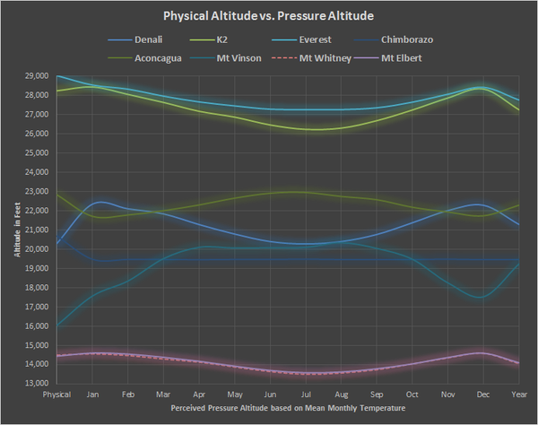
In general, the top of the troposphere is much higher near the equator and drops as you move north or south toward cooler latitudes. Gravity has very little to do with it. It’s mostly the result of hotter temperatures, as well as updrafts associated with the Intertropical Convergence Zone, where the northern and southern trade winds come together. For that reason, you could expect the air to be much thicker at the top of Mt Chimborazo than at the top of Everest. In fact, this chart of effective “pressure altitude” clearly bears this out (Everest is the bright blue-green line at the very top, Chimborazo is the dark blue line about halfway down).
This is not correct. Gravity defines the basic structure. Equal effective potential (gravity + rotation) defines mean sea level, and air pressure drops as you go higher because gravity decreases. The local secondary effects that you describe are superimposed on that basic structure.
The principal reason that Chimichanga has much higher pressures than Everest is simply because its elevation above the geoid (msl) is much lower. That’s the part that OP was missing - measuring elevation above msl is what matters, i.e. measuring effective potential, not distance from the center of the earth.
Sure, that’s trivially obvious, but that isn’t at all what I meant. I meant that the very slightly lower gravity due to being further from the earth’s center, as proposed by the OP, has virtually no influence on the air pressure at Chimborazo. You’re right, though, that although the factors I cited contribute to a much higher tropopause near the equator than closer to the poles, the difference in elevation above MSL is the principal difference accounting for air pressure, plus to some extent temperature and humidity. As one can see from the chart, perceived pressure altitude can differ significantly from physical altitude.
If the atmosphere didn’t bulge along with the land, then billions of years ago when Earth was spinning much faster, the equatorial latitudes would have been exposed to outer space.