I’ve got a bunch of photos I’d like to have the geotag added to (so that when someone looks at it, they’ll see the geotag info on the photo itself without having to right-click the properties, etc.).
Google isn’t helping, it keeps giving me ways to display the photos on a map, or ways to extract the geotag to another file, but that’s not what I want.
Is there a way to do this to a large # of files?
Like you want to add a watermark to every image with the location text? What should it say, long/lat or the nearest city name, or?
What operating system are you on?
Yes, something like that. Or just a text box at the bottom, whatever. Ideally the lat/long, whatever geo info is stored in the photo.
I’m using Windows 11
XnView can put text on a picture
If you plan to put the same text on multiple pictures, you can setup a batch process to do it in one swoop.
Your digital camera or smartphone can be set up when you actually take the picture, using the properties. They do not auto-tag directly into the image.
If you want to geo-tag directly into the image, you have to do it manually with every image.
This I did not know. I will also look into doing that for the future, thanks.
but can it do it automatically by pulling the exif data into the picture? I don’t want to manually go through all of these and add text one by one
Irfanview reads and displays Exif info/geotags and does batch renaming but it doesnt look like there is a plugin to do what you want.
Would this work for you?
I think you can do this with watermarking software like PhotoMarks: How to Watermark Photos with Metadata – PhotoMarks.app ($30). It lets you add any text from the EXIF onto the images, in bulk, through a template you define:
In the new window click on the Add Keyword button and then choose the EXIF info you’d like to insert into your images. Depending on your needs and preferences, you can add the date the photos were taken, the image dimensions and resolution, the camera make and model, f-stop, exposure or focal length data, as well as GPS coordinates.
You can probably also do it for free with IrfanView, and/or in Windows PowerShell with some scripting. How comfortable are you with things like that? ChatGPT is usually pretty good at walking you through the steps or writing the script for you.
(I can try to make it work with IrfanView, but I’m on a Mac so it might not be exactly the same)
I have limited experience with Power Shell, but enough to give it a try. It’ll give me an excuse to get better with it anyway, maybe I’ll try that.
Yeah, it should work with enough tweaking. It’s just a loop of extracting the EXIF with exiftool and then watermarking it with ImageMagick (or GD or similar if you prefer).
Example ChatGPT script at the bottom: ChatGPT - EXIF Geotag Watermarking Batch (sorry, I don’t have a functioning Windows install to test it with right now)
PS PhotoMarks does have a free trial (not sure what the limits are), but if the Powershell script doesn’t work, give that a try?
Just so there’s clarity here.
@Duckster was saying your camera can be configured to store the lat/long invisibly inside the jpg or whatever file. Most cameras are set up that way by default.
That’s where the data shown in Windows’ right-click>>Properties comes from. The camera stores it invisibly in a section of the jpg or whatever file. This is called EXIF data.
If you have images that already contain that data in the properties, the various automated ideas given above can be used to transfer it from each jpg’s EXIF/properties into a visible watermark or text box overlaid on the image.
If you have pix that don’t already have lat/long embedded in the properties, well , … you’re screwed. Those will have to be identified and labeled one at a time by hand.
Ok I misunderstood. Yeah, that’s already turned on. The files have that info, I just want to display it on the photo itself.
Yes, it seems that XnView can pull some EXIF data, it is not something I’ve done and I guess it depend where that geotag info is within your picture file.
OK I figured out to have XNView do it on one picture, now if I can just find a way to do it to all of them as a batch
XnView Batch Processing:
Go to the browse panel (Ctrl-B)
Select a few pictures to begin with
Go to Tools & Batch Processing (Ctrl-U)
From the Batch Processing panel, go to “Transformation”
Select what you want to do such as “Add Text”
At centre right of panel, press “>>” to select actions
when you’re done, press SAVE at bottom to create a script
once a script is saved, you can reuse it.
I strongly suggest that you start with some pictures in a test folder to saveguard your originals until you’re confortable with the process.
As an experiment, I wanted to see if this was a web app that AI could “vibe code”:
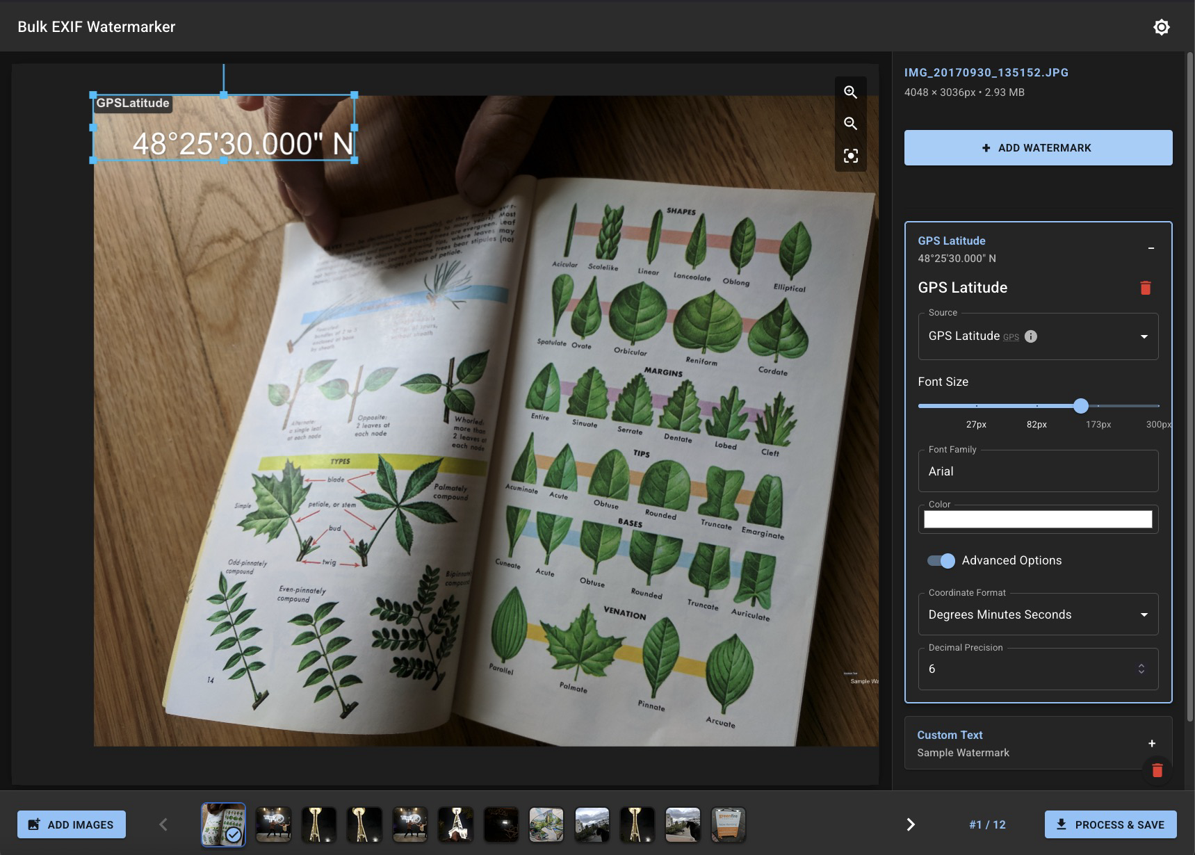
A couple hours later, it’s built something that’s somewhat functional. The basic “extract the data from EXIF, overlay it, and save it to an image” is there, but it has a lot of UI bugs.
It kinda works, but I don’t completely trust it right now. If you can’t get any of the other methods working, let me know and I can polish this up into a somewhat usable state for you. It won’t be perfect but it should get the basic job done.
(The images never get uploaded anywhere; all the processing happens on your computer only.)
This worked beautifully, thank you