It doesn’t look like these GeoResonance folks have done another scan since March 10th. I think they’re mistaking a flying plane for one under the water.
I don’t think GeoResonance is mistaking anything. In fact, I’m certain they haven’t scanned any satellite imagery at all and probably never sent a 23 page report to the authorities. I think the only thing they’ve done is send out a press release full of bullshit.
Let me explain their claim and this image that they’ve released, as I’m just now taking time to really try to understand what they’ve said.
They claim to have a satellite that takes photos. They claim to have scanned 2 million square kilometers of imagery that was taken on March 10th in the area to the north-northwest of Malaysia.
Already, I think we’re in nonsense territory. As we go on, we’ll see that their other claims would require high resolution satellite imagery but I don’t think there are any high-res satellites capable of producing 2 million square kilometers of imagery in a specific area in a single day. Since satellites are orbiting earth, they take imagery is swaths. Digitalglobe’s WorldView-2 is one of the best high-res multispectral imaging satellites around. It only takes 1 million square miles of imagery per day, and in a 16km wide swath. You can’t get 2 million square miles of imagery near Malaysia, you’d get a 16km wide stripe through the region. Lower resolution satellites like Landsat can image 13 million square kilometers per day. It can do this because each photo it takes is 115 by 115 miles (34,000 square km) in size and only at 30-100 meter resolution.
They claim that various minerals put off very faint electromagnetic fields that are detectable in these photos. They claim that they can detect these electromagnetic fields via satellite up to 5,000 meters deep within the earth (from their site).
I don’t have any specific thing to say about it except… really? Do you think you can take your cell phone outside, point it at the ground and take a photo, then look at the photo and tell us what is buried a mile below your feet? If you can, this company might hire you.
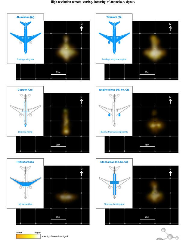
They claim to have searched all this satellite data for anomalous readings that would indicate the presence of aluminum. They then searched for titanium, copper, steel, nickel, iron and chromium.
Aluminum and iron are pretty ubiquitous in nature. Wiki says aluminium is the third most abundant element (after oxygen and silicon), and the most abundant metal, in the Earth’s crust. It makes up about 8% by weight of the Earth’s solid surface. Iron is the fourth most common element in the Earth’s crust and because of earth’s iron-nickel core is the most abundant element overall and makes up 35% of the mass of the Earth. If they put off a faint electromagnetic field, wouldn’t the planet just be abuzz from all the aluminum and iron? If you could detect it from space and drew a tiny green dot on a globe for everywhere you detected it, you’d have a tennis ball.
They claim that in one place in the Bay of Bengal, all these elements occurred in one single spot. Oddly enough, they all occur in the rough shape of a plane. The aluminum is a large blob somewhat shaped like a plane, the engine alloys are two blobs right where the engine would be, hydrocarbons are a wide blob where the engines would be, and my favorite, the copper they claim to have detected is a thin line in the shape of the wiring in a plane.
Wait… what? Let that sink in. They claim that copper emits an electromagnetic field that is extremely faint, yet somehow propagates through the faint electromagnetic field of the plane’s aluminum body, from the bottom of the ocean through 2,000 feet of water, through the atmosphere, and they can see this electromagnetic field in a satellite photo. They’ve detected wires at the bottom of the ocean from space!
Well, some people ain’t buying it.
This site is giving them a good debunking, as is the James Randi forum. There are posts and links that indicate that the website is fairly new, that a ship they claim to have found with their methods in 2005 has still never been found, that similar scammers like this have popped up over the years with similar claims of former Soviet technology that can detect chemicals underground, etc. This slashdot poster looked up the patents the company holds and claims they’re the same thing as used in “Kirlian Photography,” which is used to take photos of ghosts and people’s “aura.” I don’t have time to track down any of this. I’d say they’re right but there aren’t a lot of good cites in those forums.
Preliminary report released by Malaysian authorities:
After looking at those maps, is Magiver still supporting the mechanical issue with associated single turn to the south theory?
He didn’t accept Inmarsat’s maps, which show the same route, so…good luck with that.
I didn’t reject immarsat. I said they didn’t have anything resembling a plot-able route. They were measuring signal strength in relation to the satellite.
Malaysia Airlines 777 Missing thread
with 1,544 replies and 94,722 views.
How many replies and views will it take before any evidence is found?
one more week
one more month
one more quarter
one half year
one year
years
or never?
I have read every single post from the beginning of the thread. As it grew, not in one sitting.
I will keep it up just because I am stubborn for a while yet.
I no longer rush here first thing but I do a drive by just in case there is something new.
I have been disappointed for many days now. The arguments & interpretations of the so called facts is becoming boring.
Not to the relatives of those on the flight and such. But me, I hope the searchers are stubborn also.
Which is basically saying they don’t know where the plane was or went, and that their map can’t be believed. So why do you think they plotted that particular route on the map?
They aren’t plotting a map. they’re showing a rough arc based on signal strength. I think the distinction is worth noting. If they had a plotted map we would have found the plane by now.
Yes, and that arc starts in the northern Indian Ocean after the plane turned northwest. That’s what we’re debating here. Do you think that’s only a wild guess?
the path shown by immarsat has nothing to do with the turn west. That route is based on radar information. I haven’t read where this was corroborated by multiple radar centers (including Thailand) but that doesn’t mean it wasn’t.
There is a terrorism link now.
The Daily Mail isn’t a great source and I don’t see anything on more reputable sites, but it could still be true. The info comes from Saajid Badat, a British Muslim who was supposed to use a shoe bomb with Richard Reid in 2001 but backed out and cut ties with terrorism. He kept the shoe bomb in his home and it was found a couple years later and he was arrested and got an 11 year sentence. He was released in 2010 after testifying against some terrorists and helping authorities.
He was testifying via video recently in Abu Hamza’s trial in New York when he claimed that in 2001 Khalid Sheikh Mohammed told him to give one shoe bomb to 4-5 Malaysians for an unknown plot and to keep one for himself. He said he gave it to them and cut all ties with terrorism soon after.
Badat’s been out of the game for 13 years and Khalid Sheikh Mohammed was caught and has been in US custody for the past 11 years. If Badat knows any Malaysian terrorists that are still around, someone should certainly arrest them and look into this, but the link between this and MH370 seems pretty thin at the moment.
Is there any truth at all to the claim that there was some kind of secret cargo on the flight? If so, that would add a whole new dimension to the mystery.
Sort of a secret was how many batteries were being transported:http://www.hindustantimes.com/world-news/malaysianairlinemystery2014/mh370-mystery-of-ion-lithium-batteries-emerges/article1-1215143.aspx
They should release the NOTOC.
I just skimmed that **Atlantic **article. It was quite technical and I didn’t want to make my head hurt on a Friday night. But it is pretty damning.
I have been somewhat skeptical of the path calculated from Inmarsat, but I haven’t been able to articulate it. I know little of technology (except I do understand the math) and it just didn’t pass the sniff test.