There has been an evacuation order near Oroville Dam because of imminent failure of an auxiliary spillway. The story is here.
The auxiliary spillway came into use because the main spillway was damaged, and because the dam was so full it was in danger of overtopping. What I’d like to know is, how can the failure of a spillway lead to a flash flood? The main part of the dam is expected to hold, so that’s not it. The problem is erosion to the spillway caused by the large amount of water going over it. The Butte County Sheriff’s Office said, “Operation of the auxiliary spillway has (led) to severe erosion that could lead to a failure of the structure. Failure of the auxiliary spillway structure will result in an uncontrolled release of flood waters from Lake Oroville.”
I have no doubt that they’re right, but I don’t understand why they’re right. Please enlighten me.
Just been looking into this myself, as the media coverage seemed pretty awful to me.
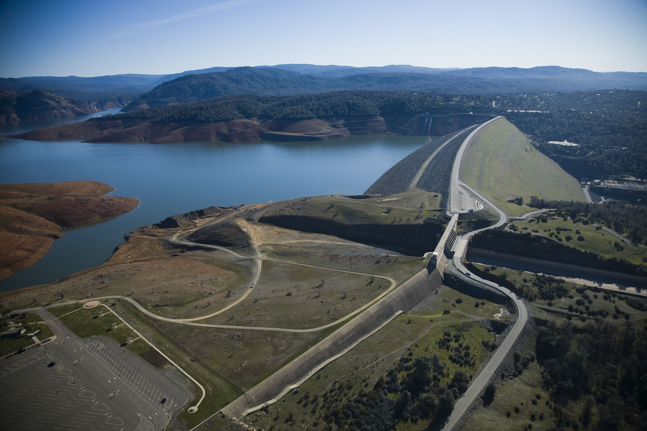
Think I worked it out. The “spillway” in question isn’t just a gully that leads away from the dam, it is actually a little mini dam (shown on the left of this picture: Imgur: The magic of the Internet). It is this that is at risk of collapsing. While not as serious as the main dam collapsing, it would in a effect be a miniature version of that.
There may be a better description in the media coverage that I have missed, but that is the best I’ve got.
I had exactly the same confusion as the OPer. To me a spillway is a channel that takes water away. Something like that main spillway (that developed a sinkhole and began this whole mess). If a channel collapses it just becomes a messier channel, I couldn’t work out how that would somehow carry MORE water than an uncollapsed channel.
What the media IMO did a bad job of explaining is the “emergency spillway” wasn’t a channel like the first one at all, it is basically a mini-dam leading to a earth slope. It is pretty obvious that is that collapses you are going to get a lot more water released .
The attempt of some posters in this thread to differentiate the auxiliary spillway from the main spillway is not exactly relevant. The main spillway itself collapsed partially, initially. Had the earth underneath the main spillway continued to be eroded backwards to undercut the concrete, the main spillway could collapse in the same way the auxiliary spillway could.
The only difference between the spillways is that the auxiliary spillway is not lined with concrete. It is thus easier for the water to erode back to the spillway, and potentially undercut the spillway lip (which is concrete).
I don’t think there is any chance that erosion of the main spillway channel can ever cause a failure of the spillway control gates. They are a massive concrete structure. At worst, they just close the control gates if the erosion gets too close.
The issue with the auxiliary spillway seems to be that it has never been tested - so no-one really has enough confidence it will survive, and if it does fail, you will get 20 feet of water released as a catastrophic lump. There is no control gate for the auxiliary spillway, unlike the main spillway. Once the water got to the top, over it went.
You will get more than “20 feet of water”. The hillside is eroding back to the spillway. Once the erosion undercuts the spillway, the spillway will be washed away. The ground under the former spillway will start to erode, and erode and erode. The feedback loop of more erosion means more, faster moving water means more erosion will continue for quite a while.
And the main spillway can definitely fail completely. Large amounts of fast moving water doesn’t care if the spillway surface is made of concrete. It’s the ground underneath that it takes out. As more and more of that washes away the concrete goes with it. The hole will work itself up the slope.
One needs to look at the pictures of the construction from the side. The auxiliary spillway is built on top of a very wide and deep hill. The actual 20 foot high bit they are worried about is a tiny bump on top of a long flat area. It seems very doubtful even torrential flooding rains will provide enough additional water flow to allow the top of this hill to erode away. https://www.metabunk.org/data/MetaMirrorCache/6c24126f4b38fe7095e62e3c751d0912.jpg
As I said, there is no reason to let the main spillway erode away. All they do is turn off the water if the erosion starts to run up the hill further. There is a significant change in slope a bit higher than where the damage is, where the slope is much shallower, and it is likely that the erosion would find it hard to get much further back than this anyway.
They’re opening the spillway because the lake is full to the top of the dam, and more water is coming in. If they close the spillway, the water coming in will go… where?
And, while I’m only partly a sort-of civil engineer, and don’t know anything about the details of this site, it seems completely plausible to me that even a massive concrete structure could be undermined by erosion. The people who are there and know what’s going on are pretty worried. If you have particular expertise or knowledge about this site that makes you so sure there’s no danger, let us know.
I’m no civil engineer (We used to joke that that was an oxymoron.)
However the thing about this dam is that there are two spillways. One, the normal one with the (damaged) concrete channel leading down the hill, and a second emergency spillway next to it, that is little more than a wide ridge with a ogee shaped hump designed so that if the water rises past a given level, no matter what, it will start to overflow and run down the hill. Over the weekend they saw some additional erosion at the base of the emergency spillway and decided to increase the flow down the main one to try to get the level down fast, even at the expense of significantly worsening the damage to the main channel. Seems they succeeded, and flow over the emergency spillway has ceased, and the damage they thought they saw isn’t so bad after all.
But it appears that no matter what, the worst expected case was loss of the 20 foot high emergency spillway ridge, and subsequent uncontrolled spilling of 20 feet of reservoir water.
Looks like the secondary spillway has stopped being used … DWR has equipment in the gully now shoring up the coffer dam … the danger seems to have past for the time being … more rain forecast for Thursday …
If the emergency secondary spillway is no longer flowing, it’s not so much a choice of the engineers. It’s purely a function of the water level in the reservoir. Seems the hope is to get some emergency work done before the next storm system.
I’m thinking that after so many years of drought, the water managers might have been reluctant to actively keep the reservoir levels down … it’s been a struggle to keep levels up to minimum so as the fall rains came it was just a natural reaction to finally get the reservoir full … except the rains kept coming and now the reservoir is too full … one more big rain event and that puppy is washing down into Sacramento …
In Western Oregon, it doesn’t matter how dry the previous winter was … we drain our reservoirs every fall down to 10% capacity … I’ve seen them fill to 89% in 7 days flat …
Here is an interview with an expert on the matter. Note that there is a serious concern about a spillway breach (either one) and the result could be as bad as draining of the reservoir. A fairly bad flood but not as completely horrible as the dam collapsing.
A spillway breach is neither unlikely nor small potatoes.
Although the breathless headline grossly overstates the reality. And as usual, they took pictures of what looks scary, not what represents the whole story.
The emergency spillway is flowing as it’s supposed to. Look at the lip: intact and smooth with a consistent flow.
It’s 100% expected that as the water flows downhill from the lip, it’ll naturally congregate into channels. Then over time those will grow into bigger channels. Given enough time eventually all the flow ends up merging into one channel some distance downstream of the lip. It’s exactly how natural rivers form, just in high speed.
Erosion of the broad surface downstream is 100% expected. What’s unpredictable is exactly where and how the channels will form. And of course if the erosion works quickly back upstream to undermine the lip structure THEN there’s a chance for a major failure.