“Not even close” seems like an overstatement. The Codilleran Ice Sheets formed in areas now part of Utah, Colorado, and New Mexico, and the Kansan Ice Sheet included parts of … surprise … Kansas. Those seem pretty close.
And FWIW googling briefly found some speculation that there may have been some mountain glaciation in “the Eagle Mountains, Davis Mountains and the Chisos Mountains of Big Bend, all in Texas” … but if so small little things.
The pertinent point is though that those southern points were not Yankee carpetbagging glaciers moving from the north but homegrown good ole boys raised there.
Just to be clear, glaciers do move. As ice builds up in areas the weight pushes the smaller portions outward. They also move downhill. They ain’t moving from Alaska to Texas though.
Okay, thanks. Happy to concede I was misinformed, although by at-the-time reputable sources who may have been repeating theoretical/unproven assumptions.
To sympathize with Amateur Barbarian on the issue of glacial migration, the notion of glaciers flowing like a river (albeit very slow), hundreds if not thousands of miles, was taught in the U.S. public school system in my day. The National Park Service, National Geographic Magazine, etal, promoted the concept… When did this theory fall into disfavor?
Glaciers are slow flowing rivers of ice. That move from high ground to low ground and eventually to the sea, creating icebergs when the ice pushes out into the ocean far enough to break off.
Glaciation is the process of larger or smaller areas of the Earth becoming covered in glaciers due to global climate changes towards colder or hotter.
As an ice age gets more severe, the glaciation spreads from the poles towards the equator. Which in the northern hemisphere means spreading from north towards south. Meanwhile the glaciers which make up the glaciation are themselves flowing downhill to the sea. Which way well be northwards, eastwards, or any other-wards.
IOW, the glaciers in a low valley formed in the nearby mountains. The glaciers in Kansas formed in Kansas from snow that fell in Kansas and never melted. They’d eventually do some combo of slide down the Missouri river course and melt in place as the climate warmed at the end of the ice age. Given the shallow slope in Kansas, probably more melt-in-place than flow-to-sea.
Two different ideas. It’d be easy for a 4th grader to get them lumped together even assuming the teacher understood or explained it correctly.
In any case significantly closer than California. But again immaterial to the relevant point that southern glaciation was in-situ and different than glacial flow.
How far south did glaciers flowing and dragging things along from north to south, from higher altitude to lower, that grade school image of glaciers shaping the Great Lakes and pulling stuff along with it, actually reach?
Most 4th grade teachers are able to differentiate between glaciation (the act of forming a glacier) and the formation of a (relatively) stable ice field, as you describe in Kansas, so I don’t think that’s the problem. Your own definition of the ice in Kansas preclude it from being considered “glacier” like.
Glaciers are generally considered to be rapidly moving (in a geologic perspective) and have far reaching topography modification characteristics… Much more influential than an ice field. The ice fields mentioned here that were formed during recent ice ages in Kansas and Texas would not generally be considered glaciers, per se, even though they were the result of the same global chill(s).
This is similar to arguing the geologic difference between ponds and lakes but… Irrespective of the nitpick in the terminology concerning glaciers, glaciation, and ice fields, my impression of the discussion here, is that it had become accepted that glaciers were essentially inert in the geographic formation of our landscape.
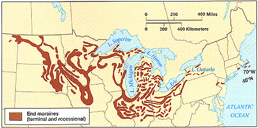
Generally, the best way would be to check a map ofterminal moraines(although that one doesn’t seem to include Long Island, and it’s definitely moraine). To that moraine line, add a short distance for the fluvial outwash plain (material carried by meltwater not the ice itself) - say, 20 miles further, if you look atone relevant outwash. And that’s how maps like the one I linked to earlier, orthis one, are made. Glacial erratics tend to be harder to pick up the further they are from that edge (or the more reworked they are) so generally the limits of the actual glaciation landforms are the limits of the deposition phase (which is actually mostly laid down during glacier retreat). Probably the furthest-carried identifiably-glacial material is the *paha *dune landform and other loess plains like along the Mississipi, made of glacial flour. But that’s not considered erratic as such and isn’t going to have gold, anyway.
Think of glaciers like waves on the shore, building up a line of driftwood and detritus- sure, the odd piece of driftwood may be picked up and carried inland by bonfire-makers, or a light piece of detritus by the wind, but generally, that high tide line is as far as the wave deposits are really said to go.
It seems I misunderstood what idea you thought had been discredited. As such what I wrote wasn’t exactly wrong, but it was useless relative to your post. Sorry.
I don’t know what you think the relevant geophysical theory was then[sup][when?][/sup] or is now. In any case it’s beyond my expertise to critique. I’d like to learn more. Care to elaborate? Maybe somebody can fill us both in.
Well, my bad.:smack: I failed to differentiate between the explanation(s) related to how glaciers are not generally attributed to the formation of placer gold, and my understanding that glaciers do on occasion, move quite long distances. I somehow misconstrued the first part (glaciers do not = placer gold), as equating to y’all thinking that the second part (glaciers do move), wasn’t true. I see now that I didn’t comprehend what was actually being said, prior to my previous post.
Either that or Glacial River Warren which took flow from Lake Agassiz to the Gulf. But I don’t really think of the glacial lake outwash floodings as strictly “glacial erratics”, as they also contain all the lacustrine deposits as well as eroded country rock the flood passes through afterwards, so it’d be very hard to identify what was glacial erratic material and what was eroded after that. Not impossible, mind you, but tedious.
OTOH, that material transported by flood would certainly qualify as “local terrain remade as a consequence of glaciers / ice sheets.”
Whether that connection is direct enough or too indirect to count for this discussion depends on which of the three or four competing topics we’re really talking about right now.
An example of a far travelled rock is at Erratic Rock State Natural Site in Oregon. Started off in the N. Rockies. Picked up by a glacier. Embedded in an iceberg that broke off during one of the Missoula Floods. Ended up in W. Oregon.
Note that the floating part played a major role in it’s transport.
Given how unusual the Missoula Floods were, they account for a relatively small amount of material in the Western US. The erratics stand out compared to the normal rocks. At the W. end of the Columbia River Gorge there was a lot of sand and gravel deposited when the water slowed down. Up to a hundred feet or so in places.*
But this is sand and gravel. Not solid granite and quartz. And the volume, while locally large, is nothing compared to the native rocks all over the place. And no one has found gold in the debris.
(The most important gold rush area in Oregon is around Sumpter in NE Oregon. Hard rock mining in ancient rock after the placer gold was picked over.)
