Is it a systematic surveying error or something else that made these county borders this way? I’d assume a surveying error because they occur latitudinally rather than longitudinally, and latitude is harder to figure:
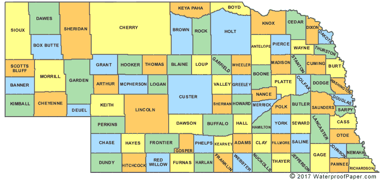
Nebraska (see Sioux, Dawes, Box Butte, Sheridan, Cherry, Brown, Rock, and Holt counties)
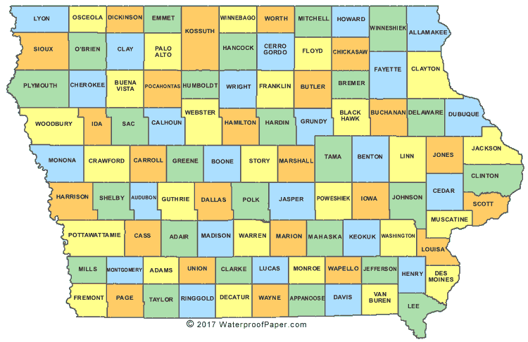
In Iowa’s case it looks like maybe they were trying to keep some uniformity of area going given how Woodbury is carved out by the Missouri, but then see Harrison.
Surely there’re other ways of ensuring equal size (though it’s not clear that’s what they were going for, given the counties’ other dimensions) besides repeating an error through several counties. When you get the Eastern border wrong, why not just say to Hell with it, rather than repeating it through the next several counties?
Most are due to surveying error. For example there are some major bends in the Utah/Colorado border which is theoretically north/south. Under US law, the border is as surveyed and agreed to (New Mexico v Texas is a famous SCOTUS case regarding the agreed to part). However, if the states agreed (and I think Congress. The Constitution talks about forming new states, not changing borders), they could change the borders given today’s modern surveying techniques.
Specific to the OP, I suppose changing county borders would be a function of state law.
Hard to tell with the maps you’ve linked to by a lot of the “errors” where north/south lines jog over slightly at regular intervals are correction lines. We wanted to survey an ellipsoid into a bunch of squares. Something had to give.
There are also real survey errors but nothing you’d see at the scale of your maps.
My hunch is not surveying error, but rather a surveying anomaly: As one gets closer to the north pole, a degree of longitude gets shorter. Survey townships, which are 6 miles square, were probably laid out long before county governments were established. While these townships aligned along the same latitude, the north-south lines are adjusted. I used to live in Jefferson County, IA, which is 437 square miles which would be 12+ townships. My hunch is that the county borders normally run along township lines. Since the north-south township lines do not line up sometimes, there’s a jog to the east/west.
I can remember traveling across the country before the Interstate system. Occasionally there would be a 90 degree jog in the road for a quarter of a mile or so before turning back to the original heading. This, my dad explained, was for this same reason.
North-south line deflections are typically caused, as stated above, from the fact that two north-south lines are not parallel to each other, but two sides of a square are – so a compensation has to somehow be made. Land holdings on the section line checker-board basis pre-existed the county demarcations. For example, the border between Saskatchewan and Manitoba has saw-tooth jogs all along it.
But east-west anomalies are usually caused by surveyors wandering off course, and two lines coming from opposite directions not meeting.
St. Martin Parish in Louisiana is a unique example of a vast plot of thousands of acres lying out in the middle of nowhere, unattached to the main part of the county. Apparently due to a surveying party mis-reporting coordinates.
As a general practice, boundaries are legally baked in once established and recognized, and the inaccuracies remain in force, even if later surveying technology proves them not in conformity with their intended locations.
These Counties are in States that were surveyed under the instructions of/for the General Land Office (GLO). I believe that what you’re seeing is the effect of trying to lay out tiers of Townships (6 mile x 6 mile ‘squares’), subdivided thence into 36 Sections (1 mile x 1 mile).
The West and East borders (Range Lines) of Townships were laid out by Solar observation and were to be oriented to True North and were run and extended north. As you can imagine, these Meridional lines were subject to a gradual convergence as they ran north and the northern boundaries shrank from the 6 mile standard.
To correct for this, ordinarily at 36 mile intervals, the Township dimension was restored to the original standard and an E/W ‘jog’ appears in the N/S line.
I can assure you that the jogs are not ‘errors’, just standard GLO instructions.
I think if you look at the superficially straight north-south border between provinces of Manitoba and Saskatchewan you see the similar effect. The border jogs to follow a due-north trajectory but accommodate locally square plots of land, since the distance is lesser at progressively higher latitudes.
Iowa’s row of funny counties was created all at once, Jan 1851.
They drew a map, but didn’t have north-south borders .
Surveyors said “but we need north south borders. and make them fit to the 6m x 6m boundaries !” It wasn’t easy , as many of the counties are right down at Iowa’s minimum area for a county - Ida is right on the lower limit ,432 m^2.
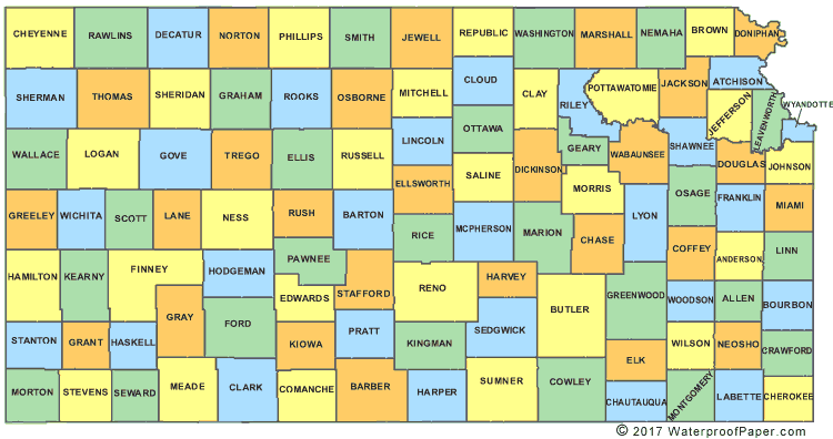
I’m willing to bet those are genuine surveying errors, not attempts to accommodate the Earth’s sphericity (not needed for E/W borders anyway) and the township system, which apparently accounts for the effect in NE, KS, IA (and likely other places).
Real surveying errors happened, though. Virginia and Tennessee had to go all the way to the Supreme Court because Thomas Jefferson’s father did such a bad job determining the correct line.