Familiar question: “How high do you have to be to see Earth’s curvature?”
Neither the questioner nor the answerers ever say what “see the curvature” means, or why it would be easier from high altitude. So: what does it mean?
How would a U-2 pilot at 60000 feet go about seeing the curvature? Earth is a circle beneath him; how can he tell that the surface is convex and not a flat disc? If he can’t “see” the convexity, he’s not seeing the curvature.
(It’s surprising how many people say that seeing the horizon’s curvature counts. As if the horizon were ever anything but a circle, seen from any altitude.)
Only way the U-2 pilot can detect the convexity is to find a straight line down there, a line that’s intended to be straight but follows Earth’s curvature. First problem: the line has to be visible to him. Next problem: the line has to be “straight” in three dimensions, not just two. Maybe Kansas has highways that run straight north-south for a hundred miles, but they’re no use to him, since their elevation varies randomly – they don’t follow the curve of the sea-level or any-other-level Earth.
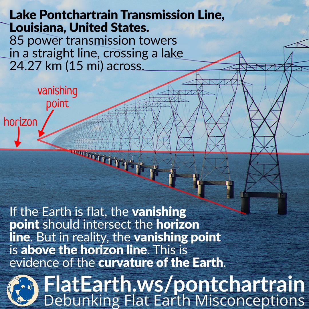
Which brings us to the Lake Pontchartrain causeway: 24 miles of what looks to be straight, level roadway. The radius of its arc is 6352 km and the arc-chord separation is 96 ft at the midpoint, less than a thousandth of its length. It will look straight, to the U-2 pilot.
So forget about high altitude. Instead, see what you can do from the Marriott at the south end of the causeway. Need to get high enough so your line of sight is about horizontal, 24 miles away – so go all the way to the roof? How often do they get clear days down there? Would something like a 400 mm lens be enough to do the job?
I have always understood seeing the earth’s curvature to be seeing the horizon as a curved line rather than a straight line not seeing the earth’s convexity.
An astronaut on the moon, or even geosychronous orbit will see the earth as a circle. Someone on the deck of a boat will see the horizon as a flat planeas the horizon is virtually on the horizontal plane. At 60,000ft the horizon is 2.17 degrees below the horizontal, is that enough to see the curvature of the earth, it is such a gradual thing I don’t think there is really a definative point, the only time I was that high (I once flew on Concorde) I didn’t notice it but the tiny windows wouldn’t help.
I’ve never been to the Lake Pontchartrain but the effect you mention can easily be observed looking at ships in the distance, you can see the mast while the hul is below the horizon, this can be observed with the naked eye but is much clearer with binoculars (or a 400mm lens)
As a circle on a flat plane just below him, you mean. Climb higher and the circle gets smaller, so the curvature is more obvious, but the circle was always curved.
Sure, ships disappear over the horizon, but that’s not “seeing the curvature”. The only curved line in that view is the horizon itself. Far as your eye can tell, what’s between you and the horizon could be flat.
Altitude actually does count. Given the size of the Earth, if it was actually a flat disk of the size needed to contain the entire surface area, at the altitude where you normally can see the curvature in the horizon (about 35,000 IIRC) it would still appear to be a straight line. As you increase your altitude to the point where you can see the curve of the edge of flat-disk earth, you would be able to see every surface feature on the planet. The fact that you can start to see the curvature of actual-earth at around 35,000 feet, and can only see the surface that appears up until the horizon curve, does in fact prove the Earth’s curvature.
I’m comparing the actual, convex surface, X square miles, with a flat disc covering the same X square miles. Not trying to fit the whole Earth into the visible circle.
“… does in fact prove the Earth’s curvature.”
Proving the curvature is easy – it’s seeing it that’s hard.
Agreed. I have read 35,000 feet is where most people (not all) can discern the curvature of the earth. Many planes fly this high (give or take) so pretty easily achievable.
50,000 feet and it is hard to miss. 100,000 feet and it can’t be missed.
As @LSLGuy mentioned, there is not a hard line…different people will notice it at different heights. At some point it is unmistakable to anyone.
I think you might not be understanding my point - curved horizon that you can see at altitude is curved because the earth is a sphere. You can’t say that a flat disk’s horizon would look the same at that equivalent altitude because a flat disk of the apparent size of the earth at 35,000 ft does not look the same.
let me put it to you this way. At 35,000 ft, the diameter of the apparent visible surface circle is about 460 miles. If the earth was actually a disk (flat or convex, doesn’t matter, It would look vastly different at that altitude. What you can see in that apparent visible surface circle at X altitude is directly related to the earth’s curvature. You are not going to see anything on the earth’s surface as arc-shaped because at the altitude you can see the curvature in the horizon, you’d need to be looking at an extremely long object to see the arc.
The curvature of the horizon, you mean. The fact that the horizon surrounds a convex disc, rather than a flat disc of the same area – that can’t be seen.
I’m comparing the actual convex disc, 460 miles diameter, with a flat disc 460 miles diameter, covered with the same features. Those two are indistinguishable.
Even in that narrow scope, Only after a certain altitude. If you were 1000 ft over a convex disc 460 miles in diameter, you will not be able to see everything on that disc. if you were 1000 ft over a flat 460 mile dia disc, you will. That is the proof you are looking at a curved surface vs a flat one.
If you really want to go down this rabbit hole there’s too many hours of idiots and savants discussing the Lake Pontchartrain causeway and how it does/doesn’t prove Earth curve.
SPOILER: It does.
Sure, it’s easy to prove the surface is must be convex, by measuring how many degrees below horizontal the horizon is. But you can’t see its convexity beneath you – you can’t see any curvature in would-be-straight-on-a-flat-disc lines. Because such lines are rare, and because their curvature is too slight. The Pontchartrain causeway’s arc-to-chord separation is 1/1300 of its length, so it will seem straight to any eye looking down on it from any altitude. Looking along it – that’s different.
By the way – if you’re looking for the best hard-to-refute evidence that Earth is round, how about this:
When you look out to sea, you see water, and you see sky. There’s a line between them – water below, air above. What is that line, if Earth is flat? Can’t very well be the edge of Earth’s disc, so what is it?
From any height, you’ll always see the horizon as a circle. The question is just whether it’s a straight circle or a curved circle.
It’s the horizon. If the Earth were an infinite flat plane, you’d see the same thing. Or, if you think otherwise, what do you think you would see on an infinite flat plane? There has to be sky above and ground (or water) below, and there has to be a boundary between those.
I think our OP has a very rigid idea about curvature and projections that prevents understanding.
Let’s all take a look at this pic of my house*:
@Timz: Do you agree that that pic shows a curved horizon in the distance? If not, we’re done. Or at least I’m done trying to penetrate your thought armor.
If one descended helicopter-like straight down from the ISS and kept taking pictures ever few miles, that obvious horizon curvature will decrease. The radius of curvature as projected into the focal plane of your POV will appear to increase. The curve gets shallower and shallower. But remains curved.
If we ignore the atmosphere for a moment, that process continues all the way down to standing on the ground. The horizon is still curved if you stand on a beach and look out to sea using your eyes located just 5-6 feet above the water. At some point in that descent the radius / gradualness of curvature becomes so large as to be indistinguishable from straight to mere human perception. But it’s still curved. And is in principle detectable given high enough imaging resolution carefully measured.
So climbing back upwards from that beach, where does curvature become visible to a discerning unaided human eye? IME, having personally done it for real, somewhere in the upper 40 thousands of feet altitude. Definitely by 50,000 feet.
Now having said all that, the atmosphere and its refraction does interfere with the simplicity of my vacuum-based thought experiment above. But it applies a consistent factor that alters the view of the curvature, not the fact of it. IOW, the atmosphere doesn’t invent the visible curvature as an illusion, nor does the atmosphere prevent seeing the visible curvature.
The difficulty with that picture is that it’s flat. A flat picture works fine, for a fairly narrow angle, but when you’re looking at a wide angle, there will always be distortions, and you have to choose which distortions you’re going to accept (it’s exactly the same problem as trying to represent a spherical Earth with a flat map). And in order to “see the curvature” in any meaningful sense, you have to be looking at a wide angle, and therefore you’ll always have distortions. Depending on the projection you use, any apparent curvature might be real, or might be an artifact of those distortions, or something that “should” be curved might look straight as a result of those distortions.
I think the point is that one can’t be sure how much of that apparent curvature is due to distortion from the short focal length lens. At some point a short focal length (wide-angle) lens is going to produce distortions, and in particular is going to tend to turn straight lines into arcs, commonly known as the “fish eye” effect.
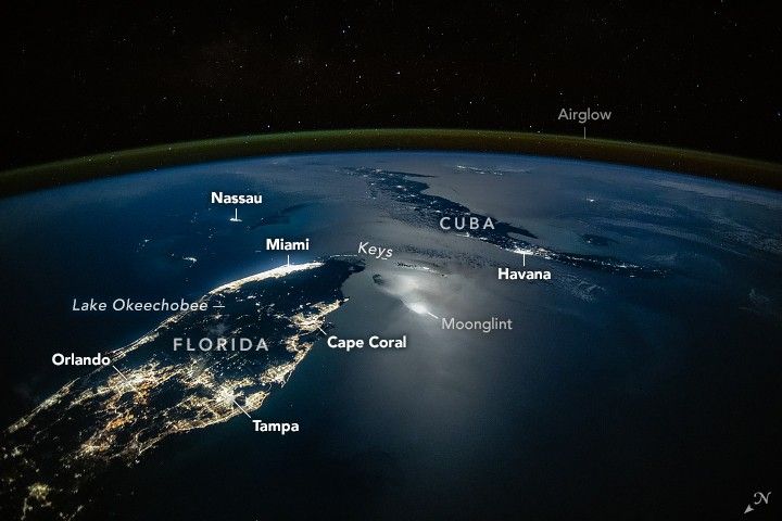
NASA says that pic was taken with a 28mm lens, which on a full-frame 35mm digital camera is definitely in the “wide angle” range. I wonder if the earth would look equally as curved if you were looking directly out the window of the ISS, or if the pic was taken, say, with a 50mm lens.
Got it. They also say the 28mm was chosen to closely mimic the field of view & shape of images seen with the naked eye.
I’m enough of a SLR photog to remember all that terminology from the old days. But not enough to say which focal length is a reasonable match for unaided human vision.
I have a vague recollection it’s not quite as simple as that, because although the eye can be decently modeled as a camera, the eye+brain cannot. And really where one ends and the next begins is lots more complicated than what happens with a film or digital image later viewed with the unaided eye.