Old thread, but it would be nice to get an answer, if we have one. How big is Greenland if we do the same thing and get rid of the ice? Heck, is it even all one island?
And, BTW, if anyone does say that Greenland is larger that Australia, they probably saw it on one of those bad map projections, like the Mercator projection. Even my grade school chose to use two hemispheres rather than do that and confuse the kids who looked at the globe.
Ice is not counted as part of a landmass. However, the Greenland ice sheet is actually smaller than the landmass, so melting it wouldn’t make the island any smaller anyway.
And of course Greenland is not one island. That would be an unbelievably rare occurrence for a landmass of that size.
The Mercator isn’t a “bad map projection”. As this site says, ‘all map projections distort the surface in some fashion.’
All have their advantages and disadvantages.
Its disadvantages are as you know. Different projections serve different purposes. If the Mercator were simply a bad projection it would have been consigned to history long ago.
Yeah, Mercator definitely has its uses. For instance, it’s the projection used by Google Maps, and indeed is the only flat projection that meets Google Maps’ needs. It just shouldn’t be the default, is all.
Personally, I don’t know why more general-purpose maps don’t use the Goode-Holosine projection, or something similarly interrupted.
I believe current theory is that Greenland is indeed an archipelago, but until all the ice melts (and sadly it appears to be an “until” and not an “unless”) we won’t know for sure.
I’m aware this is an old thread, but most rankings of area I see are always 1. Russia, 2. Canada, 3. USA, 4. China.
Occasionally I have seen rankings that go off of land area only, which moves it to 1. Russia (Lots of Land), 2. China (9,328,245 sq. km), 3. USA (9,162,391 sq. km), 4. Canada (9,094,037 sq. km.).
Interestingly the US is 3rd either way (Water + Land, or Land alone) so rankings that would have the U.S. 4th would be pretty weird/unusual.
FWIW I think the geography norm is that “inland water” is counted in this, so I don’t believe Canada’s typical area inclusive of water counts large ice sheets far off the coast. All the lakes and then all the archipelago islands in the far north of Canada there’s probably a lot of “judgment calls” about what water, in terms of geographic norms, is inland vs not.
Probably because people are conditioned to wanting to look at a non-interrupted projection. Move to a non-rectangular one first - something like a Mollweide.
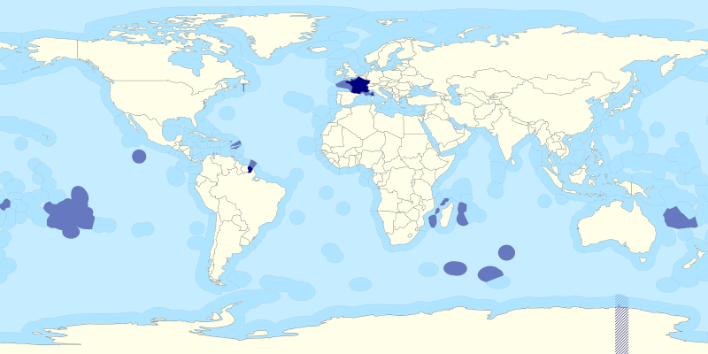
The rankings change significantly when territorial ocean water is included in area. The U.S. moves up in the rankings, and France makes it into the Top Seven, I think, just behind Brazil.
Well if you count continents as islands, then Australia is smaller than Eurasia, Africa, the Americas for sure. I’d have to look up Antarctica to see how much land is under that ice.
In the case of Greenland, isostatic rebound from the loss of the ice will counter most of the sea level rise. Well, except that Antarctica will also be melting and confounding the situation. Not that it matters that much – this is not going to be prime real estate any time soon, even if not submerged.
Yeah. Every land mass on earth is an island. And “Antarctica” refers only to the land under the ice, not the ice. It’s almost 2x the size of Australia.
Some googling around finds that island and contingent are indeed mutually exclusive so I stand corrected.
In terms of Australia I see the word can variously be applied to mainland Australia, Australia the country, and Australia the continent. And I see things get messy with some of the world’s other large landmasses. So screw it, I’m out of that side discussion

