So BP has this deep see drilling platform. It blows up and now 5,000 feet down there is basically a pipe stuck into the the ocean floor that is spewing oil.
My questions are these: IS the oil coming out do to incredible presssure forcing the oil out from under the seabed, or is it coming out simply because it is lighter than water? The distinction I am trying to make is this: If they seal the pipe with this concrete-like mud is there still a tremendous amount of pressure and if os is that a concern? My questions probably seem dumb, but I see the video feed and all I can think is that you put a cap on that but what happens to the pressure.
It is under pressure, yes. A good discussion of the physics can be found here. There is a lot of more information in the various articles on that site.
[QUOTE=The Oil Drum]
if the kill works it will actually stop the leak and allow a cement plug to be placed at the top of the well, sealing it from leaking. However the mud must be injected at a pressure greater than that within the well itself, and in sufficient volume that it will flow down the well, rather than through the BOP and out the broken riser. This is achieved by raising the flow level to such a value (in this case 1,680 gal/min of mud) that there is too much resistance for this to flow through the gap in the BOP and the flow therefore pushes back down the well, filling it with mud with sufficient density that it will overcome the pressure at the bottom of the well.
[/QUOTE]
The oil and gas in the strata that the well penetrates are at incredible pressure. Even at the sea floor the oil exits the well at over 2000psi. Capping the pipes from which the leak is eminating isn’t possible - it would just blow a hole in some other part of the pipe - since the pipe(s) and possibly the blow out preventer are damaged already they are working very gingerly to avoid making things much worse.
Killing the well relies upon adding a tall enough column of mud in the well that the weight of mud overcomes the pressure of the oil and gas at the bottom of the well. The well is 12,000 feet deep below the sea floor. It was the removal of similar mud from the well, and replacing it with seawater (which is much less dense), thus relieving some of this pressure, that was part of the chain of events that caused the accident. Once the mud weight stops the flow they will concrete the well permanently.
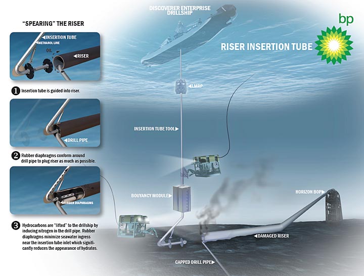
Maybe someone can help me find a particular graphic I saw at The Oil Drum a week or two ago. BTW, TOD is awesome site for this info as mentioned. I have looked through most of their threads and can not come across the link, and I really want to show it to my wife/daughter. Frustration is almost complete on my inability to locate it. :mad:
It is an ‘artists concept’ drawing of the location of the rig (after sinking), the BOP and the ‘riser pipe’ off of it, and associated sunken gear, not really to scale but showing the gist of the layout down there. My wife had no idea that there was even a very long pipe from which the oil was being routed away from the ‘hole-in-the-ground’, and I am having difficulty explaining the entire ordeal to her. In her mind, there was just a hole in the ocean floor from which oil was leaking. I gotta educate 'em on this, ya know?
Any idea on that pic or something similar? Thanks in advance! I have found pretty much every other image possible other than the one I describe.
Quick caveat; I’m an exploration geologist, not a production engineer, but my eyes and ears for the past 30 years haven’t been so discerning.
It’s reservoir pressure that’s driving the flow. Think of the millions of tons of sediment distributed annualy from the Mississippi Delta. That pressure is what’s responsible for the outflow, as it is for the subsidence and faulting distributed throughout.
If the mud and subsequent cement injection is sucessful, and my fervent hope and inclination is that it will be, that’s not all they do. They won’t then put all their bags in a “set”. Mechanical plugs will then be inserted that effectively seal the inner pipe diameter above the cement column. The two combined (very simpliestically speaking) will stem the flow.
Is that a guarantee? Well, I’m not privy to how distributed the leaks are at present. I can think of senveral thngs that might go wrong. With that much flow who knows what has been eroded by scouring, be it strata or pipe integrity. Who knows what the cement integrity is surrounding the casing stem. It could be that capping would cause the pressure to find an alternate release, possibly outside the casing.
Hopefully, the top kill and plug will be all that’s necessary. It should work, provided unforseen extenuators due to depth don’t come into play. Make no mistake about one thing though; people not familiar with the history and efforts of those in the industry can’t possibly appreciate the degree of expertise that goes into this. It’s not NASA subsea but they do have far more parallels than the layman realizes.
One more thing, the two relief wells hopefully won’t be what quells the tap but they will provide an additional layer still of protection from pollution by the blown out well. They, if not the top kill, will afford opportunities that’ll insure this ugly thing is brought under control.
90wt: close enough, for sure. Not the exact one I sought, but similarity is quite sufficient - many thanks! Sorry for the slight hijack. I even tried a rough drawing it by hand, but stick-figure disasters are not very worthy. It also does not help that the viewer is legally-blind but can see well enough to get by.
lieu - thx for your input. This is some serious business, and imho, NASA has it easy compared to some of the nowadays endeavors of ‘Big Oil’.
A question about the relief well for clarification, please: are the targets of said relief wells the actual ‘borehole’ that already exists or simply into the ‘reservoir’ itself. I have seen/heard confusing descriptions and would really like to know if drillers actually can reliably hit the borehole itself (maybe a foot or two (-ish) in width??). Appreciate the input.
They are trying to intercept the borehole, yes. I found a graphic which illustrates that but it takes a while to load, so be prepared to wait a couple of minutes for it: progress on relief well drilling. It shows the position of the two relief wells being drilled with respect to the original well, and gives the current status of their progress. It is updated periodically but I’m not sure what that time period is.
It is my understanding, from reading what some engineers are saying, that if BP/Transocean had a good 3-D location log on the well (a fairly safe bet), the relief wells will get close enough to the orginal wellbore to intercept it. Pretty cool.
And more thanks. Gets hard to sift through the BS and whatnot with so many folks giving opinion/should’ve-could’ve things rather than ‘fact’.
A few minutes ago, the live-feed video made it appear that the end of the riser-pipe thing (where most of leak is occurring, iirc) is laying in kind of a hole or depression-like structure. I assumed that the Gulf’s floor there is fairly flat/smoothish - is that wrong? It gives me even more respect for those ROV ‘drivers’ if they are having to park the subs where they won’t tumble off edge(s) yet have a good perspective; lots of other non-natural items to avoid already. Sorry if my ?'s are taking away from OP’s intent - my clarifications are probably not worth a dedicated thread.
I’m not sure about the bathymetry right there at the blowout. I found several images of the Gulf floor, but I don’t think they are of a scale to tell, really. Example.
Personally, I think that the ocean floor is like land above water - which can have valleys, depressions, hills, etc. but that’s a WAG.
(I can’t access the link so apologies if any of this is redundant.)
There are a number of reasons why it’s crucial they know exactly where their drill stem is as they drill a well. Shallow gas pockets exist in the strata that can cause blow outs and you want to avoid them. Faults may be encountered that would cause the bit to deviate and sometimes it’s preferable to address them at a certain angle. You may plan to branch out from a single hole in several directions and depths with sidetrack wells to penetrate multiple reservoirs. And of course you want to hit each target reservoir in a pretty narrowly defined area to get the best structure, porosity (and hopefully permeability), gas / oil / water window, etc. For these reasons and more as they’re making progress downhole they’ll do frequent or consistent Deviation Surveys which track the depth, inclination and azimuth. From Deviation Surveys a Position Log can be calculated. A Position Log takes the XY location of the Kelly Bushing or some static point of reference, calculates the X and Y offset and from that the Absolute X and Y value in TVDSS, true vertical depth subsea, to a minimum of 8 decimal places. This is what they use to define their target so accurately. The same mechanism, directional drilling, that allows O&G companies to drill horizontally will be utilized to get them to the exact point in the blowout’s drillstem they want to reach. They’ll then switch bits from one designed for rock to one for steel and will slowly bore into it as well. The figure I heard to cut through the existing pipe once encountered is 3 weeks.
As for the bathymetric surface, slumping, faulting, turbidity flows and varying lithologies can all create variances upon which currents then react. The floor can within general confines be somewhat unpredictable.
Another question for the experts here. How out of the ordinary is this event? I mean is it the kind of thing where somebody could have said at some point “What if this happens?” and not get the rolleyes?
From what I’ve read on The Oil Drum, from people in the industry who drill wells, having a deepwater well “kick” on you is something you should be prepared for. As lieu points out, gas pockets are commonly found during drilling and can cause blowouts. I have read that the people who operate deepwater rigs in other parts of the world were not surprised that the blowout occurred, but that the well did not have an acoustic shutoffon it.
All I know is what I’ve read from The Oil Drum, an engineering forum I’m on and similar sites, so take all this with a grain of salt.
You mean, as opposed to intercepting it closer to the top? lieu could probably answer that better than I can. I don’t know for sure, but I bet it has something to do with the stability of the formations. You know they don’t want to drill any further than they have to.
I am not an expert on any of this, but from reading other threads here on the SDMB, I got the impression from some posters who are in the O&G industry that having an acoustic shutoff probably wouldn’t have made a difference. An acoustic shutoff is one way of activating a blowout preventer. The blowout didn’t happen because the BOP’s activator failed, it was because of problems with the BOP itself. So having an acoustic shutoff woudn’t have helped.
I don’t know if my understanding of the situation is correct - anyone more knowledgeable out there please correct me if I’m wrong.
Bridget, the one thing I get from it is that regarding the many previous mentions by BP and the media of problems with the cement job, I was under the assumption that perhaps Halliburton, the cementing contractor, shared some culpability in the disaster. Instead, what your article suggests is that it was either the cement plan, prepared by and implemented by BP, that was inadequate (no middle seal) or it was their disinclination to address the fact that the reservoir had characteristics that prevented a good lower cement seal from taking hold, that the reservoir was so permeable that a solid bond did not occur between competent rock and the production casing.