I was driving past El-Sweato (El Centro) California last week and the sea level mark on a water tank got me wondering how surveyors determine precise altitude when there is no nearby known reference. I know barometric altimeters are used but that’s only precise if the local barometric pressure is already known. I suppose one could average barometric readings but were there a way for a surveyor with only mechanical instruments to accurately determine altitude with one reading if there is not a nearby known reference?
Prior to the development of GPS, traditional cartographic surveys would pick a point, more or less arbitrarily. For height above mean-sea-level this would naturally be a coastal tide gauge. This point is known as the datum point and serves as the primary reference for all maps using this survey. By definition, there can be no error in the datum point.
From there on a network of bench marks are established across the area being surveyed, usually through a form of precise spirit leveling. In the UK, these benchmarks are physical marks set up in ~200 specially constructed underground chambers. These are the secondary reference points and are subject to error in measurement (in mm) of less than twice the square root of the distance (in km) from the datum. From these bench marks, further levelling is used to establish a vast array of less precise bench marks, from which local heights are measured.
With the advent of satellite positioning, rather than use a single datum, measurements are made at a large number of locations from which a virtual datum is calculated.
This is essentially true in the US as well. Benchmarks in the literal sense are actual bronze (usually) medallions giving precise altitude as established by spirit-level surveys, placed by the USGS in rocks and other permanent land fixtures. Their location is shown on USGS maps.

Does any one know where the USGS vertical datum is?
The UK Ordnance Survey vertical datum is at Newlyn, Cornwall
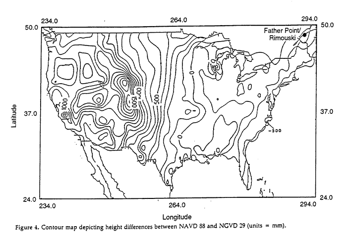
The US uses the North American Datum Vertical Datum 1988 (NAVD88), and as I understand it it is based on International Great Lakes Datum of 1985 (IGLD 85) with the height of the primary tidal benchmark at Father Point/Rimouski, Quebec, Canada, used as the fixed point.