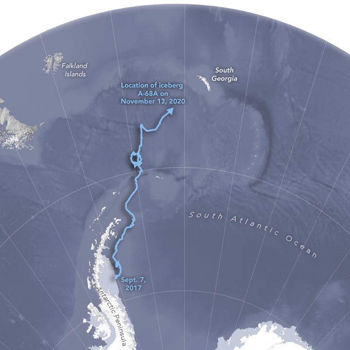
…that’s floatin’ round the south atlantic,
(you know, this one)
Why can’t i see it on google maps (satellite view, obvs) ?
Google maps is not real time imagery
yes, but it’ pretty big and it’s been there for 3 years.
It separated in 2017 though and the satellite imagery for that area claims a 2020 date. It feels like a 30+ mile long object should be visible somewhere along this path.
I’m sure there’s a good reason why it’s not but I’m also curious to learn what it is.
Well, OK, but also, the ocean areas tend to show the sonar mapping of the sea floor, not the photographic view of the ocean surface (at least in places not immediately adjacent to land)
Most of Google’s “satellite” imagery doesn’t cover areas, but lines (which I suppose are technically areas, but very narrow ones). It might be that there’s a line across that area where a plane flew in 2020 (yes, plane: That’s why I put “satellite” in quotes), but it just didn’t happen to intersect the iceberg. And really, the oceans don’t change much, so they probably haven’t put a high priority on keeping their images of open ocean up-to-date.
If a new 30+ mile long iceberg doesn’t count as worthy of a fly-over, I don’t know what else they expect to change ![]()
(That’s not to argue your point, just chuckling at “Should we bother to fly over there over the island-sized chuck of ice?” “Meh… who cares? Let’s keep photographing water…”)
In general, “the tip of the iceberg” is 1/5 to 1/7 of its height.
Not very relevant. But I did read that yesterday.
The imagery of the location where the iceberg is, isn’t water (or ice). It’s sea floor.
Well that’s no bleedin’ use !
I want to see an ice berg !
Who do i complain to ?
Perhaps you expect too much of Google Maps if no part of the iceberg is above the water. A flyover within 15 miles seems to be a big ask. Not even any nearby ad revenue from the isolated nearby Berger King.
Everyone knows that most of an iceberg is below the water, but at least some part of it must be above.
The plane may not even be flying this year because of COVID. The Google Street View cars are not going around, I know that for sure. And as best I can tell, the aerial views of land (which are taken by drones, as I understand it) are not being made either.
I did hear about a huge iceberg that was on track to ground itself near some island. Don’t know if that’s the one the OP is wanting to see, but quite possibly is.
Most certainly is, the some island in question being south georgia.
There’s some satellite imagery in this earlier report…
I wasn’t serious about the Berger King either.
But sea levels are rising, pretty soon icebergs could be completely underwater.
Google is very sporadic about their updates. I do a lot of work identifying old aerial photos and often compare them to present day conditions. I can’t tell you how many times I look for an old building and see that it is gone on the overhead view, but still there on Street View. Even more fun is one Street View I was “driving” down the block and turned a corner only to have a 4 story hotel appear. I went back and forth a few times to watch it. That hotel was razed about 5 years ago.
A few years ago, I noticed one in my mom’s neighborhood, where a prominent building was undergoing extensive renovation. In any picture taken from exactly in an intersection, you could see the building in its up-to-date state, but any picture not an an intersection, you saw the old version of the building. I have to wonder what their procedure was there: After all, the camera car had to be getting from one intersection to the next somehow. Why weren’t the cameras running while it did so?
Speculation: intersections are nodes in the vector road map data, so maybe they are treated differently, or are subject to more validation etc, and maybe don’t all get updated at the same time as the linear road stuff.
I’ve seen the same phenomenon happen pretty randomly though, where a journey along an unobstructed and straightforward road suddenly transitions from summer to winter for a few steps, then back again. I guess there are probably other factors at play
I use Street View a lot, but only from my laptop. As best I can tell, the car takes a picture every so many feet/meters. That may change depending on the speed of the car; when it’s going faster, the distance seems to get somewhat longer. So that means that there are more pictures taken at intersections.
The car may have gone down a particular road several times over the years.[*] If two pictures from different years are within a short distance of each other, it’ll show the most recent one, although you can look at the earlier ones if you want. But if a picture is in between and not close enough to two of the most recent, it’ll jump from one year to another if you move along that road. Which may be in a different season or time of day, so it’ll usually have different weather and lighting.
The cars don’t go down every road every year, so there are often wide gaps in the year-to-year coverage. This year and next year will be a gap just about everywhere. As I said above, they stopped running them because of the pandemic. And there are some roads they’ve never gone down.
.
[*] The most I’ve seen is about two dozen pictures at one spot, meaning more than one per year. Street View only goes back to 2007.