This plane popped up on my news feed and I thought it interesting.
The Bristol Freighter.
I like the utility of the design. Clam shell front doors. Engines can be swapped out in 9 hrs. payload of about 8,000 lbs. only had a range of 820 miles.
This plane popped up on my news feed and I thought it interesting.
The Bristol Freighter.
I like the utility of the design. Clam shell front doors. Engines can be swapped out in 9 hrs. payload of about 8,000 lbs. only had a range of 820 miles.
I like it. If I was still flying I’d have a decal on my plane that said “beware of dog”
Perhaps they are the sort of pilots who’ve been trained to be automation operators, not aviators.
Here’s some stuff not directly related to this event, but adjacent. …
The 737 has a lot of different flap settings for takeoff. And no mechanism to detect if the flaps are set to something different from what the performance calcs and thrust levels expect. It will alarm for an attempted no-flap takeoff, but not one with the flaps set some, but not the right “some”.
Using the minimum flap setting on a takeoff that was planned for the next notch more flaps usually results in something about like these folks experienced. You usually lift off very near the end of the runway. An analysis of data from these events showed that only about 10% of cases did the pilots stuff on full power at any point on the ground. After liftoff many more did.
The underlying reality is that nearly every takeoff in a 737 results in rotating with the far end of the runway looking worryingly close, and liftoff occurring likewise even closer to the end. That’s just the way it is, and 737 drivers quickly get used to it. No matter how alarming it looks to pilots of other jets riding the jumpseat.
The nature of acceleration adding to speed in any airplane is such that the difference between normal and abnormal is negligible back near the start of the takeoff roll, and only becomes obvious to human-level perceptions very late in the game. By which time even stuffing on full power isn’t going to change hardly anything in the time/runway remaining.
One of the things the avionics engineers are adding to all sorts of jets is both automated alerts for insufficient slowing after landing and insufficient acceleration on takeoff. The computer has better access to better data than does a person, and more CPU cycles to spend on it during a very time-critical phase of flight. But … the math remains relentless in that any warning has to come pretty late versus need if they are to avoid false alarms. Because the signal of insufficient acceleration / deceleration is very subtle at first.
My local airport. The prevailing wind here is westerly, so the usual runway in use is 27, beyond which is farmland. On the day of this incident, the wind was southeasterly, so runway 9 was used, immediately beyond which is the A38, a busy major road. There’s less than 300m between the threshold and the boundary fence, so any traffic on the road at that time would have been treated to a closer look at a B737 underside than they’d normally have had, albeit I can’t say how noticeable this would’ve been compared with a normal take off for the unprepared observer.
It seems to me that if you multiply its frequency by the potential severity of outcome, this is probably the most likely way to die on a modern airliner flown by (otherwise) competent pilots for a good airline. Albeit the absolute likelihood is still very, very low.
The NBSB has issued a final report:
The National Transportation Safety Board determines the probable cause(s) of this accident to be:
The flight crew’s decision to fly over an observed storm cell instead of deviating around it despite sufficient meteorological information indicating the potential for severe convective activity.
That’s great!
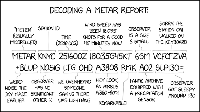
It seems to be a pretty nasty day at Munroe’s house. I know I’ve been retired awhile now, but I had to look up a couple of those codes myself. Familiar-looking, but not quite familiar enough to say what they meant.
Here’s a real (IOW non-xkcd) decode sheet for the indivdual codes, albeit not the whole METAR format: NWS - METAR ABBREVIATIONS.
Yeah, some nasty weather there. The +BLUP (heavy, blowing, unknown precipitation) seemed bad enough. But the VCFCFZVA (In the vicinity, Funnel cloud, Freezing, Volcanic ash) is quite the potent combo. Not to mention the 18035-knot winds.
The weather & precip codes are each real, if real improbable together. His explanation of the wind element is bogus; 180 degrees at 35 knots gusting to 45 is a blustery day but not a hurricane.
The one that caught my eye was A3808. That’s the altimeter setting. Or equivalently, the current barometer reading corrected from station elevation down to sea level. In inches, plausible values are roughly 2850 to 3150 (with an implied decimal point in the middle). In millibars a plausible range is maybe 950 to 1075. Whichever units he’s using, they’re experiencing serious world-ending Armageddon level high pressure. Which might go well with the 18,000 knot winds.
OTOH, overall this would be a pretty nice day on Venus. ![]()
Much of my computer programming career was in support of meteorological data systems.
I know I should be laughing at that, but I’m actually horrified. It’s an observation decoder gone horribly wrong and I viscerally worry my team might have been responsible. ![]()
In general, if you want to see what’s the worst weather in the USA at any given moment, just visit this site:
That particular location is famous for nearly continuous truly ghastly weather.
As I type, so about 1630 Eastern time on Dec 13, the actual wind is 28055G70 and they’re having FZFG BLSN.
You aren’t kidding! Gusting up to 99 mph in the last 24 hrs, currently 55 mph… current temp -3.5 F… visibility 1/16 mile. I can’t watch videos on my current connection but I can see the YouTube preview of their webcam, and it’s almost total white-out.
& it’s a tough trip up, especially on one of the few human-powered race days!
The alt text wasn’t showing up for me in the embedded image, so I went to the main xkcd site to see what it was. As usual, it’s great, too:
“In the aviation world, they don’t use AM/PM times. Instead, all times are assumed to be AM unless they’re labeled NOTAM.”
I’ve hiked up Mt. Washington a couple times, but not on a day like this. I’d like to take the cog railway, someday.
Is it really the worst weather in the country, or just the worst at a permanent observation station? The summit of Denali must be pretty nasty this time of year, but there’s nobody there to tell us.
I recently taught METAR / TAFs to an aviation class of young people. They were understandably incredulous at this ridiculous, outdated format. I explained that the teletypes they were developed for were the height of technology in the 1930s.
Now I can read a METAR as well as anybody, and I’m not necessarily advocating for getting rid of them. But I do think the FAA and ICAO should bless other forms of the data. These days it’s trivally easy to get decoded METARs and TAFs, even in flight. But we still live in a world in which BR means mist (which I was taught to remember as “barely raining”).
Newcomers to aviation huff at this nonsense, and I can’t blame them. Here’s another way of putting it: We have the ability to disseminate crucial weather reports, forecasts and pilot reports in clear language… But instead we make it a puzzle to solve. That’s just stupid in this day and age. Keep them around, sure. But there should also be “offical” regulatory regognition of decoded formats.
As long as the government-owned computer systems of 150 countries all have to store & share the data the same way, METAR will be with us. Internally. Individual countries or weather data suppliers could start delivering a decoded form.
At the same time, TAFs are themselves a severe “dumbing down” of the actual forecast data available. Unlike in 1940 when they were just a standard shorthand for everything anyone could plausibly say about the weather expected in the next 24 hours.
But there are breaks in the ghastliness. I’ve flown gliders over Mt Washington many times - we look for at least partly clear skies and enough wind (say, 30 to 50 kts) to produce mountain wave. When it works, flights above 20,000’ (over a 6288’ mountain) are more or less routine.
It’s an interesting sensation to be climbing (in super-smooth air) at 1000 ft per minute in your motorless airplane while pretty much stationary over the ground below.
It’s pretty amazing just how much nasty weather (and wave lift) you can get off such a measly short lump of rock. Where I grew up we have several ~10K peaks rising from roughly sea level land. And not nearly the exciting results.
Question prompted by the drone stuff:
One idiot posted that they shot a laser at a “drone” that was really a FedEx flight at 4000 ft. They reported that the object went dark.
In all likelihood, the plane just turned or went behind a cloud or something and they lost track of it. But suppose you’re the pilot and you just got zapped by some dipshit with a laser. Is it legal to turn off the lights for a short time so that they’re unable to target you? Is it even possible?