[QUOTE=spoke-]
The base is at the highest point in a low-lying area. You can sort of see that here. The areas all around it are lower. Again, the locals took advantage of a preexisting rise to save themselves some labor.
[/QUOTE]
Or, if they just wanted to save their food, they could have simply located 2 1/2 miles east where the ground is 130+ higher, to begin with. ![]()
Ah, here we go:
The author, noting that early descriptions of Monks Mound mention a surrounding ditch or moat, suggests that floods have washed away or filled in that moat.
Multiple cites describe Cahokia as being on a floodplain.
Which would have precluded farming the rich alluvial soils of the floodplain (unless they wanted to haul their crops 2 1/2 miles without pack animals) and would have placed them at some distance from access to water transportation.
[QUOTE=spoke-]
Which would have precluded farming the rich alluvial soils of the floodplain (unless they wanted to haul their crops 2 1/2 miles without pack animals) and would have placed them at some distance from access to water transportation.
[/QUOTE]
No. The flood plain comes right up to the hill base. They would only have had to farm the land just below their village rather than expending the hundreds of thousands of hours (that could otherwise be devoted to actual cultivation) hauling soil to create a mound for storage when they could have simply lived on a mound and farmed below it.
(What “water transportation”? They are already six miles from the Mississippi and Horseshoe Lake appears to have been cut off from the Mississippi many years prior to the building at Cahokia, so they were not relying on it for transportation. If this was a purely practical decision and transport was so important, they should have been a few miles south where the bluff ending the plain comes as close to the Mississippi as the current mound and there are still ox-bow lakes for water.)
[QUOTE=tomndebb]
No. The flood plain comes right up to the hill base. They would only have had to farm the land just below their village rather than expending the hundreds of thousands of hours (that could otherwise be devoted to actual cultivation) hauling soil to create a mound for storage when they could have simply lived on a mound and farmed below it.
[/QUOTE]
Assuming they had a flood plain map from the US Geological Survey telling them just exactly how high the waters could potentially rise. Which they didn’t.
[QUOTE=spoke-]
Assuming they had a flood plain map from the US Geological Survey telling them just exactly how high the waters could potentially rise. Which they didn’t.
[/QUOTE]
So they could figure out how high to build a mound to escape the floods that they could not predict, but they could not build a house on a hill because they did not know how high on the hill the flood waters might come?
[QUOTE=tomndebb]
So they could figure out how high to build a mound to escape the floods that they could not predict, but they could not build a house on a hill because they did not know how high on the hill the flood waters might come?
[/QUOTE]
What hill? I’ve been there. Didn’t see any hills. Did you? It’s a flood plain. How many cites do you need?
Do you mean the imperceptably gentle slope upward which you say (without citation - again) results in a 130’ rise 2 1/2 miles away? 2 1/2 miles further from water? 2 1/2 miles further from water transportation? 2 1/2 miles further from their fishery?
The date Horseshoe Lake was last part of the Mississippi River is a subject of some controversy, as I understand it. Do you have a cite?
At any rate, here’s an illustration which gives you an idea of the access to water enjoyed by the moundbuilders at Cahokia.
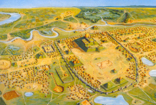
Whether or not that gave them quick access to the Mississippi, it certainly gave them quick access to fishing (on Horseshoe Lake), and to drinking water. (And also to water for irrigation in dry seasons, to the extent irrigation may have been practiced. Irrigation channels have not been found.)
But maybe they should have built 2 1/2 miles away as you suggest and just hauled the water.
You keep saying you’ve been there, but you do not recall the bluff that runs just west of Collinsville, actually providing the border of the floodplain of which you are so enamored? (The road atop the bluff is actually called “South Bluff Rd” (at least until it becomes 88th St. a few miles South where I suggested they could have had the benefit of a natural “mound” PLUS water PLUS the same distance access to the Mississippi).
I long ago conceded that some culture somewhere might have built mounds to preserve their food. However, if you’re going to persuade me that that was “really” why they were built, you’re going to have to do more than go on about how wonderful it was that they could build a mound out in the middle of a flood plain, far from the river transport that is now so important to you, and provided food storage for over 30,000 inhabitants on the tops of a few mounds that do not seem quite large enough for the purpose.
At least have the decency to admit you were flat wrong about Cahokia not being on a flood plain. Or do you need another half dozen cites?
I’m not going to defend the moundbuilders’ decision to build on that floodplain, but that’s what they did. I imagine they had their reasons. Maybe if they’d had your good counsel they’d have chosen differently. But having built on a flood plain, they had to have a place of retreat and a place to store their corn in the event of flood. Whether the still-extant mounds (and the many that have been destroyed) were enough to serve the purpose is a debate I’ll save for someone who has the courtesy to provide cites for his factual assertions. I tire of doing research for you. I’ll just note that the still-extant mounds did have graneries, and that you are most likely overstating the population of the place.
[QUOTE=spoke-]
At least have the decency to admit you were flat wrong about Cahokia not being on a flood plain.
[/QUOTE]
Ahh! So this is just an exercise in scoring points rather than a discussion. If I had realized that that was your only intent, I’d have made the big concession a few hours ago.
On the other hand, I notice that you have utterly failed to acknowledge that a very large number of mounds simply do not fit your little scenario as you hammer away on getting Cahokia onto a flood plain, so maybe I should join you in your pissing contest for unacknowledged facts.
Nah. I prefer exchanges of ideas and information over scoring points.
Of course, since you “tire” of providing my facts, I cannot resist replying to your failed attempt to denigrate the facts I have provided:
At Cahokia, a 13th century population of approximately 30,000 inhabitants. . . .
During this time there may have been as many as 30,000 people living there.
Archaeologists estimate the city’s population at between 8,000 and 40,000 at its peak. . . .
With, of course, some lower estimates:
the city covered nearly six square miles and had a population of up to 20,000
[QUOTE=tomndebb]
I prefer exchanges of ideas and information over scoring points.
[/QUOTE]
When come back, bring information. With cites.
And pie.