Traffic engineers and urban planners: Why would a short stretch of street be raised two feet?

(To set up the question, I need to lay out a substantial amount of background information, so please bear with me.)

At the intersection of Motor Avenue and National Boulevard, in the northeastern edge of Palms, there’s a commercial building on the SE corner, dating from the year 1915. From then until at least around 1930 it was shared by a blacksmith shop and the local LAFD company, which used it for auxiliary garaging and storage. Today it’s shared between a Norm’s Foams And Fabrics outlet and another store named–just to show it takes all kinds to make a world–I Love Lucite. Here’s a view from across the street, looking east across Motor Avenue.

Link

Now, here’s a still from a 1924 Little Rascals film, in which they have built a makeshift train of their own and are about to drive it into the building just described. This is on the north side of the building, where the large doorway still exists.

1924 view

You can easily see that there’s the usual curb cut, or at least infer it from the fact the train is obviously not passing over an unaltered curb. So far so good; nothing particularly unusual about that.

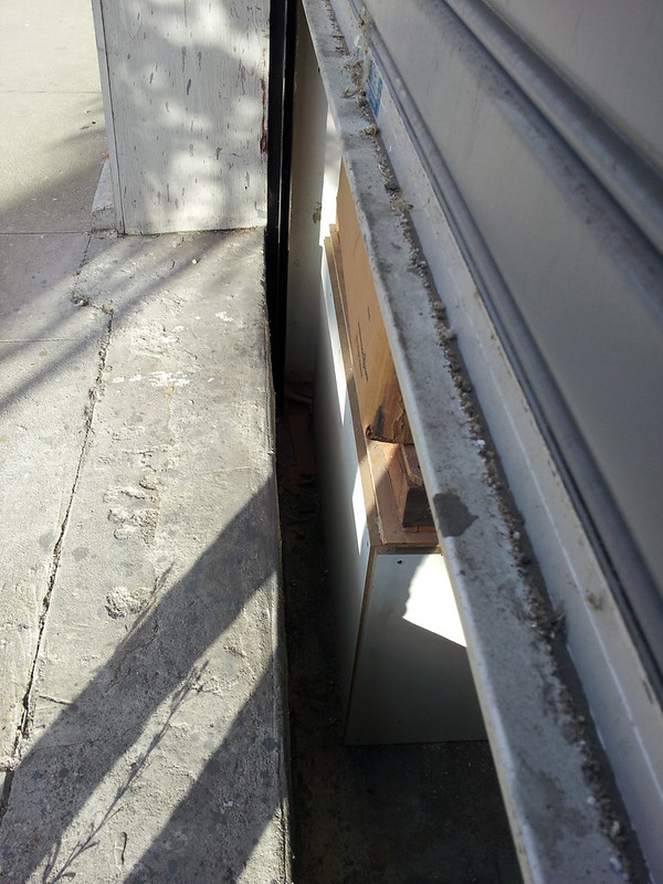
But this is where it gets strange. Here’s a picture of the door that I took myself several years ago.

Recent view

It’s easy to see that the original curb cut is now gone and this is no longer a vehicular entrance. If you look carefully towards the right edge, you’ll notice that the line where the sidewalk meets the wall of the building isn’t parallel to the window, but the sidewalk rises slightly as approaches the camera’s vantage point. You definitely notice the rise in the pavement as you walk past here. And just as quickly, if you continue walking around the corner towards the left margin in this view, the sidewalk descends back to its regular level.

And the next shot, a close-up of the former vehicular doorway confirms that the sidewalk and street are now well above their original elevation–and the interior floor of I Love Lucite. And from the 1924 shot we know that this isn’t a case of a building foundation having been excavated partially into a naturally rising stretch of ground, but rather the originally level ground, street, and sidewalk having been scrapped and artificially rebuilt to include this small hill in the road.

Recent close-up

We have now finally arrived at my question, for those of you who stayed with me that long: Why? What reason would they have had for “installing” this hillock in the road?

Drainage?

Drainage? Perhaps. But then you’d think somebody would have had that doorway permanently bricked over.

Think that’s weird? Most of downtown Seattle was re-graded one story higher after the Great Fire of 1931. It’s a major tourist attraction now.

I know this is GQ, but here I go with some guesses.

Are you certain that the floor hasn’t always been lower than the street?

Reasons it might be lower today than in the past:
[ul]
[li]Earthquake damage and or repair?[/li][li]Environmental clean-up?[/li][li]Bringing the building up to recent code changes?[/li][/ul]

The doorway is still useful for delivery & pick ups.

Dunno about that. If the problem is that when it rains, it floods, bricking up the door would still leave you with a large lake seeping through your wall – and walls aren’t designed to handle that.

Drainage in to a storm water sewer system would be my guess, which there appears one installed in the modern photo. Needing to regrade the street so water runs into the designed catch basin.

The old photo does not show that area in the shot, so can’t say if they had them back then, but if the strom water drainage system was installed later it would be a leading reason why.

where is Palms?

Between Mar Vista and Cheviot Hills on the west side.
…oh, it’s in the LA area.

Much of Sacramento (which straddles two rivers) was raised one or two stories to end perpetual springtime flooding. This would have been early, around 1880. I know it created many anomalies, some of which you can see in the “sunken” parking of the Old Sacramento [del]historical district[/del] [del]vibrant business district[/del] [del]entertainment zone[/del] tourist trap.

There is also an utterly inexplicable whoop-te-do, thankee-ma’am, hillock, mogul, ski jump or stunt ramp on a major road leading out of town that’s been there since I was a child. (We used to call it the [blank] bump because we’d hit it coming home from the usual family restaurant, and it’s NOT something you want to hit at speed with a full belly of Italian.) One of the only things I miss about Sacramento is reaching that bump in light traffic and getting a little air over it.

So raised sidewalks from 1900 or so? Sure. I’d bet there was even a good reason that didn’t entirely rest on a payoff to city services. :smiley:

Nothing to add, but my apartment for 17 years was on Clarington at Palms. :slight_smile:

I had a look at the building on Google Streetview (3304 Motor Ave, Los Angeles, CA 90034, USA). I don’t think that we are looking at the same wall as shown on the 1924 photo.
Taken from a different angle, the right-hand turn of National Blvd is clearly absent from the 1924 photo. But walking around the corner, it matches a lot better. The old door has since been bricked up, which may just be visible as a paler rectangle on the wall.
As for the floor, I would guess that it is level with the front entrance.

What’s now downtown Chicago was raised above ground level in the 1850s and 1860s, also for drainage reasons. Thus, the (in)famous Lower Wacker Drive, which runs beneath Chicago’s streets, is actually at ground level.

I think you’re right. And the whole street seems to rise gently from Motor Ave to the right-hand bend. It’s not a hillock, it just rises from the front to the back of the building.

Ah, yes, Wacker Drive, the only 8-dimensional roadway on Earth… (Upper, Lower, and the four compass points, right?)

One possibility is that it’s not that the street has been raised, it’s that the building sunk. A lot of west LA sits on top of oil fields and as they pumped oil out of them, they had problems with the overlying land subsiding. These days, in the urban portions of the oilfield, they inject water to prevent land subsidence, but back in the 30’s through the 50’s it was a major problem in some LA neighborhoods.

The fact that it only seems to be that one building that’s visibly sunk could be because it’s the only really old building left on the block?

FWIW, here’s a long dry PDF report about subsidence on the nearby Baldwin Hills area, showing that at least there from the 1910’s to the 1960’s some areas dropped almost 5 feet: http://pubs.usgs.gov/pp/0882/report.pdf

Subsidence isn’t out of the question, but it would be odd if that building were the only thing to sink. Buildings disappearing below grade are almost always the result of build-up around them.

IIRC, quite a few of the Roman ruins were in notably deep “wells” until the surrounding buildup of centuries was excavated in the 20th century.

That’s not at all uncommon. The weight of the building speeds the subsidence and plus they often just keep paving the streets and sidewalks at the same level. Here’s a page with some of the famous examples from San Francisco: http://www.ncgeolsoc.org/Field%20Trips/2005%20-%202006/SanFransisco%20Bay%20Margin%20FT/SF%20Earthquake%20Bay%20Margin%20Field%20Trip.htm

Looking at this view in Street View it looks apparent to me that the building is sunk into the street relative to the one next door. Looking around the neighborhood, it seems possible that the building is the only one that dates back to before around the 1950’s and so the other buildings wouldn’t have been around when the oilfield related subsidence was occurring.

I’m not sure the SF example is relevant to the OP’s case, since those are buildings that sank during a major earthquake and ground shift and are different from adjacent buildings only because they’re the only survivors from 1906.