Tchaikovsky didn’t include the Theremin in his 1880 score for The Year 1812, Solemn Overture, commonly known as the 1812 Overture, as the electronic instrument had not yet been invented. But cannon are sometimes used for live performances, just as the composer intended. Here are three, served and fired by artillerymen of the United States Army’s 10th Mountain Division, during a 2019 performance by the Boston Pops.
Although the 10th Mountain had very high casualties in Italy during WW2, several/many survivors came back to the USA then greatly influenced and were influential of the start of the newish American Ski industry.
MCMWTC, the Marine Corps Mountain Warfare Training Center in Bridgeport CA was established in 1951 as a cold-weather battalion. The base sits at just below 7,000 feet altitude and trains US and Allied forces to survive and operate in extreme, high-altitude environments. It is located in the Sierra Nevada mountains about 1 hour north of Yosemite National Park and 2 hours southeast of Lake Tahoe.
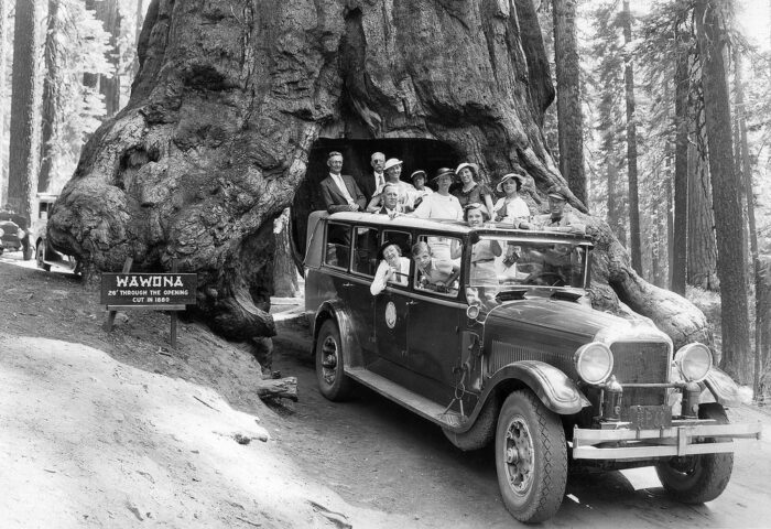
The Wawona Tree, also known as the Tunnel Tree, was a giant sequoia that grew in the Mariposa Grove, in the southernmost part of Yosemite National Park. It was 234 feet (71 m) tall, and was 90 ft (27 m) in circumference. When a carriage-wide tunnel was cut through the tree in 1881, it became even more popular as a tourist photo attraction. Carriages and automobiles traversed the road that passed through the tree. The tree was permanently weakened by the tunnel, and it fell in 1969 under a heavy load of snow. It was estimated to have been 2,100 years old.
The Maine Solar System Model, by the University of Maine at Presque Isle, is one of the largest true scale models of the Solar System in the world.
It is best viewed by automobile and extends from the Sun located on the UMPI campus and with a 15 meter diameter near the Northern Maine Museum of Science, for about 100 miles to the south along US Routes 1 and 2 to the dwarf planet Eris in Topsfield ME.
I’ve mapped out the approximate DD coordinates, and if you paste the coordinates into Google Maps it should take you just to the south of each element and within approx 100 feet of them. On Google Maps each element is labeled.
The Maine Solar System Model
△ Sun at UMPI ▲ 46.67236, -68.01579
△ Mercury ▲ 46.6676, -68.01158
△ Venus ▲ 46.6637, -68.0099
△ Earth & Moon ▲ 46.65772, -68.00649
△ Mars ▲ 46.65287, -68.00421
△ Ceres, Asteroid Belt ▲ 46.6389, -67.9976
△ Jupiter ▲ 46.6033, -67.97253
△ Saturn ▲ 46.5484, -67.92607
△ Uranus ▲ 46.4195, -67.84322
△ Neptune ▲ 46.2608, -67.84083
△ Pluto ▲ 46.2402, -67.84118
△ Eris dwarf planet ▲ 45.9116, -68.333036
➜ https://www.mainesolarsystem.com ■
➜ https://www.atlasobscura.com/places/maine-solar-system-model ■
➜ Solar System model - Wikipedia ■
The Maine Solar System Model is advertised on Instagram here:
➜ https://www.instagram.com/reel/Dah5WJRxlw8 ■
Near the Maine Solar System Model and a little farther south are two spots labeled on the map as Million Dollar Views:
△ Million Dollar View Overlook ▲ 45.7373, -67.8757
△ Million Dollar View Outlook ▲ 45.6929, -67.862
These might possibly be worth a visit.
(Deleted, too slow to finish my post!)
Sorry buddy. I did see you were in the process of inserting a post, but my quick copy & paste ninja’d you and I knew that was likely to happen.
((No worries! It happens, and I was multi-tasking while composing.))
The state of Maine contains 17.52 million acres of forest, which is 89 percent of the total land area of the state. This is the highest percentage of forest cover of any state. Almost 92% of the forested-land is privately owned.
West Quoddy Head in Lubec, Maine, is the easternmost spot in the continental US. From it’s famous red and white striped lighthouse you can see the rising sun before anyone else in the country. (With the exceptional of Pochnoi Point on Semisopochnoi Island, Alaska, part of the Aleutian chain of islands, which is technically the furthest eastern point in the US by virtue of being across the International Date Line.)
Not in play.
Adding this:
Brochure, Maine Solar System Model. The model was completed in 2008.
⏵ Jupiter includes only the 4 Galilean moons which are the only ones able to be shown at this scale
⏵ Saturn only includes 1 moon, Titan (again, due to scale)
⏵ The other moons of other planets are too small to be shown
Again, not in play.
Not in play: I’ve been there!
In play: Maine is the only US state name with a single syllable. And it is the only state that borders exactly 1 other state.
Maine may border the fewest states (not counting Alaska and Hawai’i), but two states share the record for bordering the most other states, with eight. And, they border each other! Missouri borders (clockwise from north) Iowa, Illinois, Kentucky, Tennessee, Arkansas, Oklahoma, Kansas and Nebraska. Tennessee borders (clockwise from north) Kentucky, Virginia, North Carolina, Georgia, Alabama, Mississippi, Arkansas and Missouri.
While we’re on the subject of state borders…
There are four states that border two, and only two other states. Unsurprisingly, they are all located on a coast:
Florida: Borders only Alabama and Georgia.
Rhode Island: Borders only Connecticut and Massachusetts.
South Carolina: Borders only Georgia and North Carolina.
Washington: Borders only Idaho and Oregon.
Continuing with state borders…
There are 60 US state tripoints (count ‘em — 60!!). These are the points where 3 and only 3 state borders converge at a single geographic point. 36 tripoints are on dry land. 24 tripoints are in water.
Wiki has a page for these. The 36 tripoints on dry land are listed here:
➜ https://en.wikipedia.org/wiki/List_of_tripoints_of_U.S._states#Land ■ , and the 24 tripoints in water are listed here listed here:
➜ https://en.wikipedia.org/wiki/List_of_tripoints_of_U.S._states#Water ■ .
The Northwest Angle is a small “bump” on Minnesota’s northern border that juts into Canada. It’s just a small corner of land attached to a peninsula on the Canada side and separated from the United States by the Lake of the Woods. It exists because the U.S. and Britain signed treaties recognizing U.S. independence and the boundaries of the Louisiana Territory before this area had been completely explored. The language of those treaties created this anomaly, which was simply left in place.
So have I! I stayed with friends from Bangor and we went there, on our way 'round the horn to Halifax and Yarmouth, then ferried to Bar Harbor, and up to Mt. Cadillac to see the sunset. My regret is not seeing Aroostook; my friends convinced me it was just taiga and no one but hunters and lumberjacks went there.
(In play) I haven’t looked at the previous poster’s link, but I’m certain it includes the unusual border between the US and Canada at Point Roberts, WA. You can only access it by auto (or sea, if you’re adventurous). You must pass the border checkpoint to get in and to get out. There’s not much there to see but it was on my bucket list.
Mister Roberts is a 1946 novel by Thomas Heggen, which he based on his experiences serving in the U.S. Navy in the Southwest Pacific during World War II.
The novel was adapted into a play in 1948, which won five Tony Awards, including for Henry Fonda as Best Performance for a Leading Actor, for portraying Lieutenant Roberts. A 1955 film adaptation of the novel, which also starred Fonda in the same role, was nominated for three Academy Awards; Jack Lemmon won the Best Supporting Actor Oscar as Ensign Pulver.
Starfleet in the various incarnations of Star Trek tends to follow the Royal Navy and United States Navy convention (as seen in Mister Roberts) of senior officers referring to junior ones as “Mr. [Lastname],” as with “Mr. Sulu” and “Mr. Chekov” on ST:TOS, “Mr. LaForge” and “Mr. Data” on ST:TNG, “Mr. Nog” on ST:DS9, and so on.
British Surgeons are called “Mister” not Doctor, going back to the early 1700s, when Medical Doctors had a university medical degree. Surgeons did not, have any degrees then. So even now, when Surgeons have a Medical degree, the tradition is preserved.